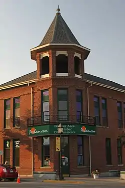
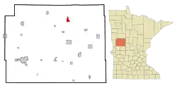
Perham, Minnesota
Perham (/ˈpɜːrəm/ PUR-əm) is a city in Otter Tail County, Minnesota, United States. The population was 2,985 at the 2010 census.[5]
Perham | |
|---|---|
 | |
| Nickname(s): "P-Town" | |
 Location of Perham, Minnesota | |
| Coordinates: 46°35′42″N 95°34′26″W | |
| Country | United States |
| State | Minnesota |
| County | Otter Tail |
| Government | |
| • Mayor | Tim Meehl |
| Area | |
| • Total | 3.59 sq mi (9.29 km2) |
| • Land | 3.59 sq mi (9.29 km2) |
| • Water | 0.00 sq mi (0.00 km2) |
| Elevation | 1,368 ft (417 m) |
| Population | |
| • Total | 2,985 |
| • Estimate (2019)[3] | 3,645 |
| • Density | 1,016.45/sq mi (392.45/km2) |
| Time zone | UTC-6 (Central (CST)) |
| • Summer (DST) | UTC-5 (CDT) |
| ZIP code | 56573 |
| Area code(s) | 218 |
| FIPS code | 27-50470 |
| GNIS feature ID | 0649298[4] |
| Website | http://www.ci.perham.mn.us/ |
History
Perham was platted in 1873, and named for Josiah Perham, first president of the Northern Pacific Railway.[6] As the village grew in economic importance, the surrounding township was renamed Perham Township in 1877 and Perham was incorporated in 1881.[6]
Geography
According to the United States Census Bureau, the city has a total area of 3.18 square miles (8.24 km2), all land.[7]
U.S. Route 10 and Minnesota State Highways 78 and 108 are three of the main routes in the community.
Demographics
| Historical population | |||
|---|---|---|---|
| Census | Pop. | %± | |
| 1880 | 269 | — | |
| 1890 | 761 | 182.9% | |
| 1900 | 1,182 | 55.3% | |
| 1910 | 1,376 | 16.4% | |
| 1920 | 1,370 | −0.4% | |
| 1930 | 1,411 | 3.0% | |
| 1940 | 1,534 | 8.7% | |
| 1950 | 1,926 | 25.6% | |
| 1960 | 2,019 | 4.8% | |
| 1970 | 1,933 | −4.3% | |
| 1980 | 2,086 | 7.9% | |
| 1990 | 2,075 | −0.5% | |
| 2000 | 2,559 | 23.3% | |
| 2010 | 2,985 | 16.6% | |
| 2019 (est.) | 3,645 | [3] | 22.1% |
| U.S. Decennial Census[8] 2013 Estimate[9] | |||
2010 census
As of the census[2] of 2010, there were 2,985 people, 1,304 households, and 722 families living in the city. The population density was 938.7 inhabitants per square mile (362.4/km2). There were 1,388 housing units at an average density of 436.5 per square mile (168.5/km2). The racial makeup of the city was 94.1% White, 1.1% African American, 0.5% Native American, 0.5% Asian, 0.1% Pacific Islander, 2.3% from other races, and 1.5% from two or more races. Hispanic or Latino of any race were 4.8% of the population.
There were 1,304 households, of which 27.3% had children under the age of 18 living with them, 38.9% were married couples living together, 11.9% had a female householder with no husband present, 4.6% had a male householder with no wife present, and 44.6% were non-families. 38.0% of all households were made up of individuals, and 19.4% had someone living alone who was 65 years of age or older. The average household size was 2.19 and the average family size was 2.89.
The median age in the city was 41.5 years. 22.6% of residents were under the age of 18; 9.2% were between the ages of 18 and 24; 22.1% were from 25 to 44; 22.7% were from 45 to 64; and 23.4% were 65 years of age or older. The gender makeup of the city was 46.5% male and 53.5% female.
2000 census
As of the census of 2000, there were 2,559 people, 1,104 households, and 642 families living in the city. The population density was 976.2 people per square mile (377.1/km2). There were 1,167 housing units at an average density of 445.2 per square mile (172.0/km2). The racial makeup of the city was 96.99% White, 0.35% African American, 1.02% Native American, 0.27% Asian, 0.66% from other races, and 0.70% from two or more races. Hispanic or Latino of any race were 1.13% of the population. 50.3% were of German and 14.8% Norwegian ancestry.
There were 1,104 households, out of which 29.3% had children under the age of 18 living with them, 45.5% were married couples living together, 8.9% had a female householder with no husband present, and 41.8% were non-families. 37.1% of all households were made up of individuals, and 20.7% had someone living alone who was 65 years of age or older. The average household size was 2.23 and the average family size was 2.95.
In the city, the population was spread out, with 25.1% under the age of 18, 6.9% from 18 to 24, 25.7% from 25 to 44, 17.6% from 45 to 64, and 24.7% who were 65 years of age or older. The median age was 40 years. For every 100 females, there were 87.9 males. For every 100 females age 18 and over, there were 82.9 males.
The median income for a household in the city was $28,397, while the median income for a family was $40,184. Males had a median income of $29,087 versus $20,817 for females. The per capita income for the city was $16,444. About 8.1% of families and 13.2% of the population were below the poverty line, including 15.3% of those under age 18 and 13.9% of those age 65 or over.
Radio stations
- FM radio
- 92.5 KXKK 92.5 Hot Country
- 94.5 KDLB Adult Contemporary The Arrow 94.7
- 97.5 KDKK 97.5 Music of Your Life
- 99.5 KPRW Lakes 99.5
- 99.9 KVOX-FM Froggy 99.9
- 100.3 KXPM-LP Relevant Radio
- 102.3 KRCQ Real Country 102.3
- 107.9 KPFX 107.9 The Fox
- 97.9 KFNW Contemporary Christian Music Life 97.9
- AM radio
Notable people
- Gabriele Grunewald, U.S. champion middle distance runner
- Fritz Hanson, legendary Canadian Football League pioneer
- John Anthony Kaiser, Roman Catholic priest
- Roger Molander, government official and activist
- Ray Taylor, film director
- Larry N. Vanderhoef, 5th chancellor of University of California-Davis
See also
References
- "2019 U.S. Gazetteer Files". United States Census Bureau. Retrieved July 26, 2020.
- "U.S. Census website". United States Census Bureau. Retrieved 2012-11-13.
- "Population and Housing Unit Estimates". United States Census Bureau. May 24, 2020. Retrieved May 27, 2020.
- "US Board on Geographic Names". United States Geological Survey. 2007-10-25. Retrieved 2008-01-31.
- "2010 Census Redistricting Data (Public Law 94-171) Summary File". American FactFinder. U.S. Census Bureau, 2010 Census. Retrieved 23 April 2011.
- Upham, Warren (1920). Minnesota Geographic Names: Their Origin and Historic Significance. Minnesota Historical Society. p. 397.
- "US Gazetteer files 2010". United States Census Bureau. Archived from the original on 2012-07-02. Retrieved 2012-11-13.
- United States Census Bureau. "Census of Population and Housing". Retrieved September 10, 2013.
- "Annual Estimates of the Resident Population: April 1, 2010 to July 1, 2013". Retrieved June 9, 2014.
External links
| Wikimedia Commons has media related to Perham, Minnesota. |
Municipalities and communities of Otter Tail County, Minnesota, United States | ||
|---|---|---|
| Cities | 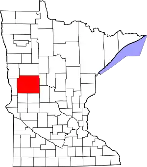 Map of Minnesota highlighting Otter Tail County | |
| Townships |
| |
| Unincorporated communities | ||
| Indian reservation | ||
| Ghost towns | ||
| Footnotes | ‡This populated place also has portions in an adjacent county or counties | |
| ||