Otter Tail County, Minnesota
Otter Tail County is a county in the U.S. state of Minnesota. As of the 2010 United States Census, its population was 57,303.[1] Its county seat is Fergus Falls.[2]
Otter Tail County | |
|---|---|
 | |
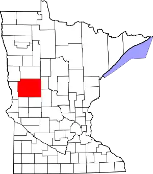 Location within the U.S. state of Minnesota | |
 Minnesota's location within the U.S. | |
| Coordinates: 46°25′N 95°43′W | |
| Country | |
| State | |
| Founded | March 18, 1858 (created) September 12, 1868 (organized) |
| Named for | Otter Tail Lake and Otter Tail River |
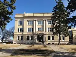
| Seat | Fergus Falls |
| Largest city | Fergus Falls |
| Area | |
| • Total | 2,225 sq mi (5,760 km2) |
| • Land | 1,972 sq mi (5,110 km2) |
| • Water | 252 sq mi (650 km2) 11%% |
| Population (2010) | |
| • Total | 57,303 |
| • Estimate (2019) | 58,746 |
| • Density | 29.8/sq mi (11.5/km2) |
| Time zone | UTC−6 (Central) |
| • Summer (DST) | UTC−5 (CDT) |
| Congressional district | 7th |
| Website | ottertailcountymn |
Otter Tail County comprises the Fergus Falls micropolitan statistical area.
History
Native Americans used the area for hunting and fishing, and had permanent dwelling sites. Two Native American tribes were in constant conflict. The Dakota (Sioux) were being pushed from their home area by the Ojibwa (Chippewa) during the late 18th and early 19th centuries. Burial mounds and artifacts can still be found. Some of the oldest Native American remains were found near Pelican Rapids, Minnesota. The remains, nicknamed Minnesota Girl, were dated at about 11,000 BC.

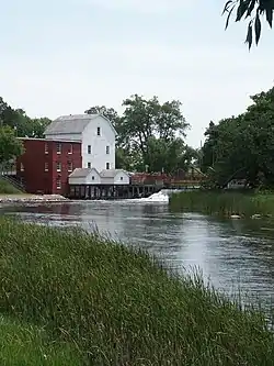
The first white men to enter the county were French and British fur traders. Efforts were made to set up trading posts on the Leaf Lakes and Otter Tail Lake. In the late 19th century, most of the towns were built along the railroad lines. Lumber and agriculture were the major industries in the county at that time. The pine and hardwood forests, transportation system, and markets were instrumental in the development of Fergus Falls into a lumber center. The Wisconsin Territory was established by the federal government effective July 3, 1836, and existed until its eastern portion was granted statehood (as Wisconsin) in 1848. The federal government set up the Minnesota Territory effective March 3, 1849. The newly organized territorial legislature created nine counties across the territory in October of that year. One of those original counties, Dakota, had a section partitioned off in 1851 to create Cass County. On March 18, 1858, the outgoing territorial legislature created Otter Tail County from areas partitioned from Cass and Pembina, another of the original counties created in 1849. The county was named for Otter Tail Lake and the Otter Tail River.[3] The county was not organized in 1858, nor was a county seat specified. On September 12, 1868, the legislature completed the county organization, and specified Otter Tail City as county seat.
Otter Tail City began as a waystation on a fur-trade route between Saint Paul and the Red River valley. The settlement was of sufficient size that when the Minnesota Territory established a US land office for this part of the territory, the office was sited at Otter Tail City. Thus, the city was named as the seat when the county was organized, but people had begun settling the future Fergus Falls area in 1857, and it grew sufficiently that in fall 1872, the vote was taken to move the county seat there.[4] The Northern Pacific Railroad had initially planned to run a line through Otter Tail City, but complications caused the line to be placed in Fergus Falls, which precipitated the county seat move. The Soo Line later made plans to run a line through Otter Tail City, but when townspeople could not agree on the routing, another route east of the city was constructed. Thus, a new city plat was generated, with the settlement name changing to Ottertail.[5]
In 1870, the population of the county was about 2,000. At that time, the principal languages spoken in the county were Norwegian, Swedish, German, and English.
The people of Fergus Falls organized a new county named Holcomb. In 1872, a legislative act abolished Holcomb County, added additional townships to the west, and established Fergus Falls as Otter Tail County's seat.
Geography
The Otter Tail River flows south and west through the central and western parts of the county on its way to form the Red River in Wilkin County. It is joined by the south-flowing Pelican River west of Fergus Falls. The Leaf River rises in the county and flows east to its confluence with the Crow Wing River in neighboring Wadena County. The Redeye River flows southeast through the county's northeast section toward its confluence with the Leaf in Wadena. The county terrain consists of rolling hills, heavily wooded through its center section, dotted with lakes and ponds, and carved with drainages and gullies. The available area is devoted to agriculture.[6] The county terrain slopes to the west and south.[7] The highest point on the county terrain is attributed to two different points: Inspiration Peak, at 1,750 ft (533m), or an unnamed rise located 1.3 miles (2.1 km) west-northwest of Perch Lake, at 1,790 ft (546m) above sea level.[8] Satellite data[7] supports the probability that the point WNW of Perch Lake is higher. The county has a total area of 2,225 square miles (5,760 km2), of which 1,972 square miles (5,110 km2) are land and 252 square miles (650 km2) (11%) are covered by water.[9] Otter Tail is one of 17 Minnesota savanna region counties with more savanna soils than either forest or prairie soils. According to its website, the county contains over 1,000 lakes.
Transportation
Airports
- Aerovilla Airport[6] - 2 miles (3 km) NW of Perham
- Battle Lake Municipal Airport[11] - 1.6 mile (2.6 km) NNE of Battle Lake
- Fergus Falls Municipal Airport (FFM) - 3.8 miles (6.1 km) W of Fergus Falls
- Henning Municipal Airport (05Y) - 1.1 mile (1.8 km) S of Henning
- Pelican Rapids Municipal Airport (47Y) - 4.6 miles (7.4 km) NNW of Pelican Rapids
- Perham Municipal Airport (16D) - 1 mile (1.6 km) NW of Perham
- Wadena Municipal Airport (ADC) - 3.4 miles (5.5 km) W of Wadena
Adjacent counties
- Becker County - north
- Wadena County - northeast
- Todd County - southeast
- Douglas County - south
- Grant County - southwest
- Wilkin County - west
- Clay County - northwest
Protected areas[6]
- Aastad State Wildlife Management Area
- Amor State Wildlife Management Area
- Bluff Creek State Wildlife Management Area
- Davies State Wildlife Management Area
- Dead Lake State Wildlife Management Area
- Doran State Wildlife Management Area
- Eagle Lake State Wildlife Management Area
- Eastern Township State Wildlife Management Area
- Elmo State Wildlife Management Area
- Folden Woods State Wildlife Management Area
- Glendalough State Park
- Hi-View State Wildlife Management Area
- Inman State Wildlife Management Area
- Inspiration Peak State Wayside Park
- Jensen Memorial State Wildlife Management Area
- Maplewood State Park
- Orwell State Wildlife Management Area
- Otter Tail Prairie Scientific and Natural Area
- Prairie Ridge State Wildlife Management Area
- Valdine State Wildlife Management Area
Demographics
| Historical population | |||
|---|---|---|---|
| Census | Pop. | %± | |
| 1860 | 240 | — | |
| 1870 | 1,968 | 720.0% | |
| 1880 | 18,675 | 848.9% | |
| 1890 | 34,232 | 83.3% | |
| 1900 | 45,375 | 32.6% | |
| 1910 | 46,036 | 1.5% | |
| 1920 | 50,818 | 10.4% | |
| 1930 | 51,006 | 0.4% | |
| 1940 | 53,192 | 4.3% | |
| 1950 | 51,320 | −3.5% | |
| 1960 | 48,960 | −4.6% | |
| 1970 | 46,097 | −5.8% | |
| 1980 | 51,937 | 12.7% | |
| 1990 | 50,714 | −2.4% | |
| 2000 | 57,159 | 12.7% | |
| 2010 | 57,303 | 0.3% | |
| 2019 (est.) | 58,746 | [12] | 2.5% |
| US Decennial Census[13] 1790-1960[14] 1900-1990[15] 1990-2000[16] 2010-2019[1] | |||
2000 census
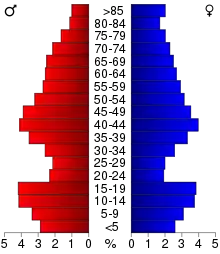
As of the 2000 United States Census, there were 57,159 people, 22,671 households, and 15,779 families in the county. The population density was 29.0/sqmi (11.2/km2). There were 33,862 housing units at an average density of 17.2/sqmi (6.63/km2). The racial makeup of the county was 97.11% White, 0.29% African American, 0.51% Native American, 0.44% Asian, 0.05% Pacific Islander, 0.84% from other races, and 0.78% from two or more races. Hispanic or Latino of any race were 1.67% of the population. 35.5% were of German and 31.2% Norwegian ancestry.
There were 22,671 households, out of which 30.3% had children under the age of 18 living with them, 60.1% were married couples living together, 6.1% had a female householder with no husband present, and 30.4% were non-families. 26.6% of all households were made up of individuals, and 13.30% had someone living alone who was 65 years of age or older. The average household size was 2.46 and the average family size was 2.98.
The county population contained 24.9% under the age of 18, 7.2% from 18 to 24, 24.2% from 25 to 44, 24.7% from 45 to 64, and 19.0% who were 65 years of age or older. The median age was 41 years. For every 100 females there were 100.4 males. For every 100 females age 18 and over, there were 97.8 males.
The median income for a household in the county was $35,395, and the median income for a family was $42,740. Males had a median income of $30,151 versus $20,930 for females. The per capita income for the county was $18,014. About 6.7% of families and 10.1% of the population were below the poverty line, including 12.1% of those under age 18 and 11.1% of those age 65 or over.
Politics
| Year | Republican | Democratic | Third parties |
|---|---|---|---|
| 2020 | 65.4% 23,800 | 32.9% 11,958 | 1.7% 641 |
| 2016 | 64.4% 20,939 | 28.7% 9,340 | 6.8% 2,221 |
| 2012 | 59.6% 18,860 | 38.4% 12,165 | 2.0% 645 |
| 2008 | 55.3% 18,077 | 42.4% 13,856 | 2.3% 754 |
| 2004 | 61.3% 19,734 | 37.4% 12,038 | 1.3% 406 |
| 2000 | 59.5% 16,963 | 34.5% 9,844 | 6.0% 1,704 |
| 1996 | 45.7% 11,808 | 40.7% 10,519 | 13.6% 3,523 |
| 1992 | 41.5% 11,074 | 34.4% 9,176 | 24.1% 6,420 |
| 1988 | 57.0% 14,015 | 42.2% 10,373 | 0.9% 216 |
| 1984 | 61.3% 15,664 | 38.0% 9,714 | 0.7% 173 |
| 1980 | 57.7% 15,091 | 34.9% 9,108 | 7.4% 1,939 |
| 1976 | 49.4% 12,113 | 48.5% 11,881 | 2.1% 516 |
| 1972 | 62.2% 13,519 | 36.3% 7,881 | 1.5% 331 |
| 1968 | 60.3% 12,483 | 35.8% 7,400 | 4.0% 818 |
| 1964 | 51.3% 10,542 | 48.6% 9,997 | 0.1% 26 |
| 1960 | 62.9% 13,747 | 36.9% 8,054 | 0.2% 42 |
| 1956 | 65.9% 12,764 | 33.9% 6,571 | 0.2% 40 |
| 1952 | 75.0% 16,447 | 24.6% 5,388 | 0.4% 86 |
| 1948 | 61.3% 11,131 | 36.0% 6,546 | 2.7% 495 |
| 1944 | 67.6% 12,351 | 31.9% 5,823 | 0.6% 110 |
| 1940 | 63.5% 13,737 | 35.6% 7,705 | 0.9% 187 |
| 1936 | 49.1% 8,899 | 47.7% 8,642 | 3.1% 569 |
| 1932 | 43.7% 7,416 | 51.9% 8,805 | 4.4% 743 |
| 1928 | 68.3% 11,624 | 29.3% 4,990 | 2.4% 411 |
| 1924 | 55.5% 7,557 | 4.2% 568 | 40.4% 5,504 |
| 1920 | 78.5% 11,084 | 12.3% 1,741 | 9.2% 1,294 |
| 1916 | 54.3% 4,328 | 35.9% 2,858 | 9.8% 780 |
| 1912 | 11.5% 755 | 26.6% 1,739 | 61.9% 4,052 |
| 1908 | 58.1% 3,964 | 34.0% 2,320 | 7.9% 542 |
| 1904 | 73.7% 4,642 | 13.8% 869 | 12.5% 788 |
| 1900 | 47.2% 3,446 | 44.6% 3,257 | 8.2% 600 |
| 1896 | 42.7% 3,544 | 54.0% 4,482 | 3.2% 268 |
| 1892 | 37.4% 2,140 | 28.7% 1,642 | 33.9% 1,940 |
Otter Tail is a Republican stronghold in U.S. presidential elections, having voted for the party's candidates in every election since 1936.[18] The only Democrats to win the county since Minnesota became a state in 1858 have been Franklin D. Roosevelt in his first election victory, and unsuccessful candidate William Jennings Bryan in 1896.
During the Great Depression, there was a communist faction within the county. The areas where the movement was centered are quite desolate today, but in mid-1932 over 900 people were involved in one of the state's communist organizations at what was a historic low point for farmers. The members of the communist party were very active in the New York Mills area of Newton, Leaf Lake, Blowers, Deer Creek and Paddock Townships. They held meetings, recruited members, placed candidates on local and state tickets, and distributed propaganda. They held dances in Heinola, Menahga, and Sebeka where the Soviet hammer and sickle was proudly displayed and ran a summer camp on East Leaf Lake.[19]
By the time Franklin Roosevelt implemented his New Deal programs in the county, the communist movement began to lose steam. In addition, the Winter War in Europe between Finland and the U.S.S.R. soured many Finnish immigrants on communism (Finns had been a large proportion of the local communists). Carl Peltoniemi, a former local communist, said, "The communist movement within the Finnish community basically ended at the start of the Winter War in 1939–1940."
In the Minnesota House of Representatives, Otter Tail County is divided into two districts, 8A and 8B. They are represented by Republicans Bud Nornes (8A) and Mary Franson (8B). Districts 8A and 8B make up Minnesota State Senate district 8, which is represented by Republican State Senator Bill Ingebrigtsen.
Communities

Cities
- Battle Lake
- Bluffton
- Clitherall
- Dalton
- Deer Creek
- Dent
- Elizabeth
- Erhard
- Fergus Falls (county seat)
- Henning
- New York Mills
- Ottertail
- Parkers Prairie
- Pelican Rapids
- Perham
- Richville
- Rothsay (part)
- Underwood
- Urbank
- Vergas
- Vining
- Wadena (part)
Unincorporated communities
Townships
- Aastad Township
- Amor Township
- Aurdal Township
- Blowers Township
- Bluffton Township
- Buse Township
- Butler Township
- Candor Township
- Carlisle Township
- Clitherall Township
- Compton Township
- Corliss Township
- Dane Prairie Township
- Dead Lake Township
- Deer Creek Township
- Dora Township
- Dunn Township
- Eagle Lake Township
- Eastern Township
- Edna Township
- Effington Township
- Elizabeth Township
- Elmo Township
- Erhards Grove Township
- Everts Township
- Fergus Falls Township
- Folden Township
- Friberg Township
- Girard Township
- Gorman Township
- Henning Township
- Hobart Township
- Homestead Township
- Inman Township
- Leaf Lake Township
- Leaf Mountain Township
- Lida Township
- Maine Township
- Maplewood Township
- Newton Township
- Nidaros Township
- Norwegian Grove Township
- Oak Valley Township
- Orwell Township
- Oscar Township
- Otter Tail Township
- Otto Township
- Paddock Township
- Parkers Prairie Township
- Pelican Township
- Perham Township
- Pine Lake Township
- Rush Lake Township
- Scambler Township
- St. Olaf Township
- Star Lake Township
- Sverdrup Township
- Tordenskjold Township
- Trondhjem Township
- Tumuli Township
- Western Township
- Woodside Township
References
- "State & County QuickFacts". United States Census Bureau. Archived from the original on June 7, 2011. Retrieved September 1, 2013.
- "Find a County". National Association of Counties. Retrieved June 7, 2011.
- Otter Tail County Website "Archived copy". Archived from the original on 25 June 2009. Retrieved 9 April 2009.CS1 maint: archived copy as title (link)
- Upham, Warren. Minnesota Geographic Names (1920), pp. 396-400 (accessed 26 April 2019)
- Ottertail MN: History of the community (accessed April 26, 2019)
- Otter Tail County MN Google Maps (accessed 26 April 2019)
- ""Find an Altitude/Otter Tail County MN" Google Maps (accessed 26 April 2019)". Archived from the original on 21 May 2019. Retrieved April 27, 2019.
- Otter Tail County High Point, Minnesota. PeakBagger.com (accessed 26 April 2019)
- "2010 Census Gazetteer Files". US Census Bureau. August 22, 2012. Archived from the original on September 21, 2013. Retrieved October 24, 2014.
- Nelson, Steven (2011). Savanna Soils of Minnesota. Minnesota: Self. pp. 53 - 56. ISBN 978-0-615-50320-2.
- Battle Lake Muni Google Maps (accessed April 26, 2019)
- "Population and Housing Unit Estimates". Retrieved March 26, 2020.
- "US Decennial Census". US Census Bureau. Retrieved October 24, 2014.
- "Historical Census Browser". University of Virginia Library. Retrieved October 24, 2014.
- "Population of Counties by Decennial Census: 1900 to 1990". US Census Bureau. Retrieved October 24, 2014.
- "Census 2000 PHC-T-4. Ranking Tables for Counties: 1990 and 2000" (PDF). US Census Bureau. Retrieved October 24, 2014.
- Leip, David. "Atlas of US Presidential Elections". uselectionatlas.org. Retrieved October 10, 2018.
- Sullivan, Robert David; ‘How the Red and Blue Map Evolved Over the Past Century’; America Magazine in The National Catholic Review; June 29, 2016
- Tweton, Jerome (1988). The New Deal at the Grass Roots: Programs for the People in Otter Tail County, Minnesota. St. Paul: Minnesota Historical Society Press. pp. 29–31.
External links
| Wikimedia Commons has media related to Otter Tail County, Minnesota. |
- Otter Tail Country Tourism Association
- Otter Tail County, Minnesota official government’s website
- Otter Tail County Historical Society
Places adjacent to Otter Tail County, Minnesota | ||||||||||
|---|---|---|---|---|---|---|---|---|---|---|
| ||||||||||
Municipalities and communities of Otter Tail County, Minnesota, United States | ||
|---|---|---|
| Cities | Map of Minnesota highlighting Otter Tail County | |
| Townships |
| |
| Unincorporated communities | ||
| Indian reservation | ||
| Ghost towns | ||
| Footnotes | ‡This populated place also has portions in an adjacent county or counties | |
| ||

| Authority control |
|---|