Pinedale, Arizona
Pinedale is an unincorporated community in Navajo County, Arizona, United States. The population was 487 at the 2010 census. The elevation is approximately 6,500 ft (2,000 m) and it is part of the Mogollon Rim mountain range.
Pinedale, Arizona | |
|---|---|
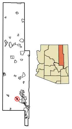 Location of Pinedale in Navajo County, Arizona. | |
 Pinedale, Arizona Location within the state of Arizona  Pinedale, Arizona Pinedale, Arizona (the United States) | |
| Coordinates: 34°18′N 110°14′W | |
| Country | United States |
| State | Arizona |
| County | Navajo |
| Area | |
| • Total | 9.68 sq mi (25.07 km2) |
| • Land | 9.68 sq mi (25.07 km2) |
| • Water | 0.00 sq mi (0.00 km2) |
| Population (2010) | |
| • Total | 487 |
| • Estimate (2016)[2] | N/A |
| Time zone | UTC-7 (Mountain (MST)) |
| FIPS code | 04-55840 |
Pinedale was first known as Mortenson, after Neils Mortenson who established a Mormon settlement there in 1879. It was also known as Percheron, for the breed of stallions which Mortenson had brought with him. By 1888, however, the settlement was called Pinedale.
The former Pinedale Elementary School is now a historic building.
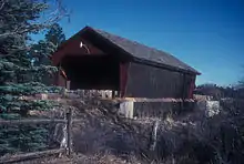
Marreta B. Thomas Covered Bridge near Pinedale
Demographics
| Historical population | |||
|---|---|---|---|
| Census | Pop. | %± | |
| 2010 | 487 | — | |
| U.S. Decennial Census[3] | |||
As of the census[4] of 2010, there were 487 people, 186 households, and 135 families residing in Pinedale.
References
- "2016 U.S. Gazetteer Files". United States Census Bureau. Retrieved Jul 18, 2017.
- "Population and Housing Unit Estimates". Retrieved June 9, 2017.
- "Census of Population and Housing". Census.gov. Retrieved June 4, 2016.
- "American FactFinder". United States Census Bureau. Archived from the original on 2020-02-13. Retrieved 2018-10-10.
External links
This article is issued from Wikipedia. The text is licensed under Creative Commons - Attribution - Sharealike. Additional terms may apply for the media files.