R290 road (Ireland)
The R290 road is a regional road in Ireland linking the R287 and the N59 in County Sligo.[2]
| |
|---|---|
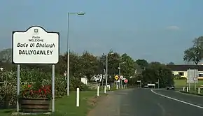 R290 entering Ballygawley | |
| Route information | |
| Length | 14.7 km[1][2] (9.1 mi) |
| Major junctions | |
| From | |
| |
| To | |
| Road network | |
From the R287, the road goes west via Ballintogher before reaching Ballygawley and briefly joining the R284. From Ballygawley, the road continues west to the N4 and Collooney. From Collooney the road follows the route of the former N4 before reaching the N59 at Ballysadare. The R290 is 14.7 km (9.1 mi) long.[1]
See also
References
- Google (5 March 2016). "R290 to R290" (Map). Google Maps. Google. Retrieved 5 March 2016.
- "S.I. No. 54/2012 – Roads Act 1993 (Classification of Regional Roads) Order 2012". Government of Ireland. 28 February 2012. Retrieved 5 March 2016.
This article is issued from Wikipedia. The text is licensed under Creative Commons - Attribution - Sharealike. Additional terms may apply for the media files.