R341 road (Ireland)
The R341 road is a regional road in Ireland. It is a loop road from the N59 road in County Galway.[2] South of the R342, the road is part of the Wild Atlantic Way.[3]
| |
|---|---|
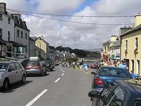 R341 in Roundstone, Co. Galway | |
| Route information | |
| Length | 37.7 km[1][2] (23.4 mi) |
| Major junctions | |
| From | |
| To | |
| Location | |
| Primary destinations | |
| Road network | |

Route
The R341 travels south from the N59 passing Ballynahinch Castle and through the village of Roundstone. The road then travels west past Maumeen Lough before heading north to Ballyconneely. Finally the road reaches Clifden where it rejoins the N59. The R341 is 37.7 km (23.4 mi) long.[1] The inland side of the road is largely occupied by the Connemara Bog Complex Special Area of Conservation.[4]
History
There are two significant historical sites by the R341. About 5 km (3 mi) south of Clifden, a memorial marks the place where the transatlantic flight of Alcock and Brown landed. Further along the road, near Ballyconneely, is the site where Guglielmo Marconi established the first transatlantic telegraph service.[5]
See also
References
- Google (14 March 2016). "R341 to Main St." (Map). Google Maps. Google. Retrieved 14 March 2016.
- "S.I. No. 54/2012 – Roads Act 1993 (Classification of Regional Roads) Order 2012". Government of Ireland. 28 February 2012. Retrieved 14 March 2016.
- "Wild Atlantic Way Itineraries". Fáilte Ireland. Retrieved 14 March 2016.
- "Conservation Objectives: Connemara Bog Complex SAC" (PDF). National Parks and Wildlife Service (Ireland). p. 51. Retrieved 14 March 2016.
- Gray, Paul (2011). The Rough Guide to Ireland (10th ed.). Penguin Books. ISBN 978-1-4053-8918-1.