Roth (district)
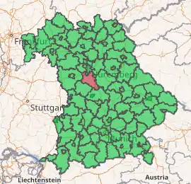
Roth is a Landkreis (district) in Middle Franconia, Bavaria, Germany. It is bounded by (from the northeast and clockwise) the districts of Nürnberger Land, Neumarkt, Eichstätt, Weißenburg-Gunzenhausen, Ansbach and Fürth, and the cities of Schwabach and Nürnberg.
Roth | |
|---|---|
 Coat of arms | |
| |
| Country | Germany |
| State | Bavaria |
| Adm. region | Middle Franconia |
| Capital | Roth |
| Area | |
| • Total | 895 km2 (346 sq mi) |
| Population (31 December 2019)[1] | |
| • Total | 126,749 |
| • Density | 140/km2 (370/sq mi) |
| Time zone | UTC+01:00 (CET) |
| • Summer (DST) | UTC+02:00 (CEST) |
| Vehicle registration | RH, HIP |
| Website | www |
In medieval times the area was ruled by many lords. Brandenburg-Ansbach and Nuremberg owned possessions in the territory, and other parts were the property of clerical states. When these clerical states were dissolved in 1803, the territory fell to Bavaria.
The district was established in 1972 through the merger of the former districts of Roth, Schwabach and Hilpoltstein.
Coat of arms
The coat of arms displays:
|
Towns and municipalities
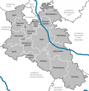
Towns and municipalities in Landkreis Roth
| Towns | Municipalities | |
|---|---|---|
References
- "Tabellenblatt "Daten 2", Statistischer Bericht A1200C 202041 Einwohnerzahlen der Gemeinden, Kreise und Regierungsbezirke". Bayerisches Landesamt für Statistik und Datenverarbeitung (in German). July 2020.
External links
| Wikimedia Commons has media related to Landkreis Roth. |
- Official website (German)
Towns and municipalities in Roth (district) | ||
|---|---|---|
| Authority control |
|---|
This article is issued from Wikipedia. The text is licensed under Creative Commons - Attribution - Sharealike. Additional terms may apply for the media files.