Rural City of Ararat
Ararat Rural City is a local government area in Victoria, Australia, located in the western part of the state. It covers an area of 4,211 square kilometres (1,626 sq mi) and in June 2018 had a population of 11,795.[1]
| Rural City of Ararat Victoria | |||||||||||||||
|---|---|---|---|---|---|---|---|---|---|---|---|---|---|---|---|
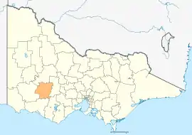 Location in Victoria | |||||||||||||||
| Population | 11,795 (2018)[1] | ||||||||||||||
| • Density | 2.8010/km2 (7.2545/sq mi) | ||||||||||||||
| Established | 1994 | ||||||||||||||
| Gazetted | 23 September 1994[2] | ||||||||||||||
| Area | 4,211 km2 (1,625.9 sq mi)[1] | ||||||||||||||
| Mayor | Cr Jo Armstrong [3] | ||||||||||||||
| Council seat | Ararat | ||||||||||||||
| Region | Western Victoria | ||||||||||||||
| State electorate(s) | |||||||||||||||
| Federal Division(s) | Wannon | ||||||||||||||
| Website | Rural City of Ararat | ||||||||||||||
| |||||||||||||||
It includes the towns of Ararat, Armstrong, Dunneworthy, Lake Bolac, Moyston, Pomonal, Streatham, Tatyoon, Wickliffe and Willaura. It was formed in 1994 from the amalgamation of the City of Ararat, Shire of Ararat and parts of the Shire of Mortlake and Shire of Stawell.[2][4]
Ararat Rural City is governed and administered by the Ararat Rural City Council; its seat of local government and administrative centre is located at the council headquarters in Ararat. The Rural City is named after the main urban settlement located in the north of the LGA, that is Ararat, which is also the LGA's most populous urban centre with a population of 8,076.[5]
Council
Current composition
The council is composed of seven councillors elected to represent an unsubdivided municipality.[6]
| Ward | Councillor | Notes | |
|---|---|---|---|
| Unsubdivided | Cr Gwenda Allgood | ||
| Cr Jo Armstrong | Mayor | ||
| Cr Peter Beales | |||
| Cr William Waterston | |||
| Cr Bob Sanders | |||
| Cr Henry Burridge | |||
| Cr Rob Armstrong | |||
Administration and governance
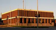
The Ararat Rural City Council meets on the third Tuesday of each month at 6pm in the Council Chamber at the Ararat Shire Hall, 239 Barkly Street, Ararat. The Ararat Municipal Offices, 59 Vincent Street, Ararat, is the location of the council's administrative activities. It also provides customer services at this location and is open from 8.15am to 5.15pm on week days.
Main towns in shire
In June 2018 the shire had a population of 11,795.[1]
| Town | Population |
|---|---|
| Ararat | 8,297 |
| Armstrong | 88 |
| Buangor | 103 |
| Dunneworthy | 19 |
| Elmhurst | 183 |
| Lake Bolac | 330 |
| Mafeking | 19 |
| Maroona | 110 |
| Mininera | 62 |
| Moyston | 348 |
| Pomonal | 322 |
| Rossbridge | 32 |
| Streatham | 156 |
| Tatyoon | 110 |
| Westmere | 40 |
| Wickliffe | 113 |
| Willaura | 530 |
See also
- List of localities (Victoria)
References
- "3218.0 – Regional Population Growth, Australia, 2017-18: Population Estimates by Local Government Area (ASGS 2018), 2017 to 2018". Australian Bureau of Statistics. Australian Bureau of Statistics. 27 March 2019. Retrieved 25 October 2019. Estimated resident population, 30 June 2018.
- Victoria Government Gazette – Online Archive (1837–1997). "S63 of 1994: Order estg the Rural City of Ararat". State Library of Victoria. State Government of Victoria (published 23 September 1994). pp. 23–29. Retrieved 10 January 2014.
- "Councillor Profiles". Ararat Rural City. Ararat Rural City. Retrieved 18 April 2018.
- Victoria Government Gazette – Online Archive (1837–1997). "S4 of 1995: Order altg (Part 3) the Rural City of Ararat". State Library of Victoria. State Government of Victoria (published 20 January 1995). pp. 2–3. Retrieved 10 January 2014.
- Census QuickStats (2011). "Ararat (SS) – SSC20024". Australian Bureau of Statistics. Government of Australia. Retrieved 10 January 2014.
- Local Government in Victoria. "Ararat Rural City Council". Department of Transport, Planning and Local Infrastructure. State Government of Victoria. Retrieved 10 January 2014.