Shire of Loddon
The Shire of Loddon is a local government area in Victoria, Australia, located in the northern part of the state. It covers an area of 6,696 square kilometres (2,585 sq mi) and in June 2018 had a population of 7,513.[1]
| Shire of Loddon Victoria | |||||||||||||||
|---|---|---|---|---|---|---|---|---|---|---|---|---|---|---|---|
 Location in Victoria | |||||||||||||||
| Population | 7,513 (2018)[1] | ||||||||||||||
| • Density | 1.12201/km2 (2.9060/sq mi) | ||||||||||||||
| Established | 1995 | ||||||||||||||
| Gazetted | 19 January 1995[2] | ||||||||||||||
| Area | 6,696 km2 (2,585.3 sq mi)[1] | ||||||||||||||
| Mayor | Cr Cheryl McKinnon | ||||||||||||||
| Council seat | Wedderburn | ||||||||||||||
| Region | Northern Victoria | ||||||||||||||
| State electorate(s) | |||||||||||||||
| Federal Division(s) | Mallee | ||||||||||||||
| Website | Shire of Loddon | ||||||||||||||
| |||||||||||||||
It includes the towns of Inglewood, Boort, Serpentine, Pyramid Hill and Wedderburn. It was formed in 1995 from the amalgamation of the Shire of East Loddon, Shire of Gordon, Shire of Korong, and parts of the Rural City of Marong, Shire of Bet Bet, Shire of Maldon and Shire of Tullaroop.[2]
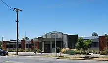
The Shire is governed and administered by the Loddon Shire Council; its seat of local government and administrative centre is located at the council headquarters in Wedderburn, it also has a service centre located in Serpentine. The Shire is named after the Loddon River, a major geographical feature that meanders through the LGA.
Council
Current composition
The council is composed of five wards and five councillors, with one councillor per ward elected to represent each ward.[3]
| Ward | Councillor | Notes | |
|---|---|---|---|
| Boort | Neil Beattie | ||
| Inglewood | Colleen Condliffe | ||
| Tarnagulla | Geoff Curnow | ||
| Terrick | Cheryl McKinnon | Mayor (2017-) | |
| Wedderburn | Gavan Holt | ||
Administration and governance
The council meets in the council chambers at the Serpentine Municipal Offices. It also provides customer services at both its administrative centre in Wedderburn, and its service centre in Serpentine.
Main towns in shire
In June 2018 the shire had a population of 7,531.[1]
| Town | Population |
|---|---|
| Arnold | 47 |
| Bears Lagoon | 72 |
| Boort | 873 |
| Borung | 82 |
| Bridgewater On Loddon | 326 |
| Dingee | 206 |
| Durham Ox | 74 |
| Eddington | 96 |
| Fentons Creek | 105 |
| Inglewood | 1,058 |
| Korong Vale | 168 |
| Laanecoorie | 177 |
| Mitiamo | 117 |
| Mysia | 43 |
| Newbridge | 192 |
| Prairie | 66 |
| Pyramid Hill | 430 |
| Rheola | 56 |
| Serpentine | 192 |
| Shelbourne | 452 |
| Tarnagulla | 133 |
| Wedderburn | 663 |
| Yando | 40 |
| Yarraberb | 23 |
References
- "3218.0 – Regional Population Growth, Australia, 2017-18: Population Estimates by Local Government Area (ASGS 2018), 2017 to 2018". Australian Bureau of Statistics. Australian Bureau of Statistics. 27 March 2019. Retrieved 25 October 2019. Estimated resident population, 30 June 2018.
- Victoria Government Gazette – Online Archive (1837–1997). "S2 of 1995: Order estg (Part 7) the Shire of Loddon". State Library of Victoria. State Government of Victoria (published 19 January 1995). p. 3. Retrieved 10 January 2014.
- Local Government in Victoria. "Loddon Shire Council". Department of Transport, Planning and Local Infrastructure. State Government of Victoria. Retrieved 10 January 2014.
External links
- Loddon Shire Council official website
- Metlink local public transport map
- Link to Land Victoria interactive maps
- Loddon Shire Promotional, Events & Investment Website