City of Kingston
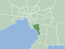
The City of Kingston is a local government area in Victoria, Australia in the south-eastern suburbs of Melbourne, its northern boundary lying approximately 15 km from the Melbourne city centre[2] along the north-eastern shorelines of Port Phillip. It covers an area of 91 km² and has an estimated population of 163,431 people.[1][2]
| City of Kingston Victoria | |||||||||||||||
|---|---|---|---|---|---|---|---|---|---|---|---|---|---|---|---|
 | |||||||||||||||
| Population | 163,431 (2018)[1] (44th) | ||||||||||||||
| • Density | 1,796/km2 (4,651/sq mi) | ||||||||||||||
| Established | 1994 | ||||||||||||||
| Area | 91 km2 (35.1 sq mi)[1] | ||||||||||||||
| Mayor | Steve Staikos | ||||||||||||||
| Location | 15 km (9 mi) from Melbourne city centre | ||||||||||||||
| Council seat | Cheltenham | ||||||||||||||
| Region | Melbourne | ||||||||||||||
| State electorate(s) | |||||||||||||||
| Federal Division(s) | |||||||||||||||
 | |||||||||||||||
| Website | City of Kingston | ||||||||||||||
| |||||||||||||||
Council structure
Corporate management
- Chief Executive Officer, Julie Reid[3]
- General Manager Corporate Services, Paul Franklin[3]
Governance, People & Culture, Communications & Community Relations, Financial Services, Information Services and Procurement & Contracts - General Manager Planning and Development, Jonathan Guttmann[3]
City Development, City Strategy, Economic Development and Statutory Education & Compliance - General Manager Organisational City Assets and Environment, Samantha Krull[3]
Property, Arts & Leisure, Parks & Recreation, Traffic & Transport and Infrastructure - General Manager Community Sustainability, Mauro Bolin[3]
Community & Aged Services, Library & Education Services, Access Care Southern, Family, Youth & Children's Services and Community Buildings
Election results
At the 2020 election, the councillors re-elected included Tamsin Bearsley, George Hua, Georgina Oxley, David Eden and Steve Staikos with a “big thumbs up” from almost 60 per cent of voters. Cameron Howe was “comfortably elected”, joined by Tracey Davies, Chris Hill, Hadi Saab, Tim Cochrane and Jenna Davey-Burns as the six new councillors.[4]
Elected representatives
Kingston City Council | |
|---|---|
| Type | |
| Type | Council of the City of Kingston |
| Structure | |
Council political groups | |
Starting in November 2020 the City of Kingston commenced a new ward system with 11 wards each electing a single Councillor.[5] This new system was introduced by the Victorian Government under the Local Government Act 2020.[5]
| Ward | Party | Councillor | Notes | |
|---|---|---|---|---|
| Banksia | Independent | Cameron Howe | ||
| Bunjil | Labor[6] | Steve Staikos[7] | ||
| Caruana | Liberal[6] | George Hua | ||
| Chicquita | Independent | Tracey Davies | ||
| Como | Independent | Chris Hill | ||
| Karkarook | Labor | Hadi Saab | ||
| Longbeach | Labor[6] | Georgina Oxley [8] | ||
| Melaleuca | Independent | Tim Cochrane | ||
| Sandpiper | Labor[6] | David Eden [9] | ||
| Wattle | Independent | Jenna Davey-Burns | ||
| Yammerbrook | Liberal[6] | Tamsin Bearsley | ||
Council services
The Council has an annual budget of approximately $122.2 million (2007/08)[10] with works involving areas such as road maintenance and construction, community, cultural and youth activities, town planning and development, waste management and recycling, maintenance of parks and public areas, public health and animal control, library services, and business and tourism support.
Suburbs
- Aspendale
- Aspendale Gardens
- Bonbeach
- Braeside
- Carrum
- Chelsea
- Chelsea Heights
- Cheltenham (shared with the City of Bayside)
- Clarinda
- Clayton South
- Dingley Village
- Edithvale
- Heatherton
- Highett (shared with the City of Bayside)
- Mentone
- Moorabbin
- Mordiallioc
- Oakleigh South (shared with the City of Monash)
- Parkdale
- Patterson Lakes
- Waterways
History
The City of Kingston area was originally governed by the Moorabbin Roads Board, which formed in 1862 and became a shire council in 1871, covering a large area of mixed agricultural and semi-urban land. After years of agitation, in 1917 the seaside town of Sandringham became a borough with its own council, and this fuelled the desire of those living in towns further south to combine their efforts and demand self-representation. This finally occurred in May 1920 and the "Borough of Mordialloc and Mentone" was formed. It became a town in 1923 and the City of Mordialloc in 1926.
In 1994, the state government amalgamated local councils all over Victoria, as part of its local government reform. The new City of Kingston was one result, comprising all of the City of Chelsea, most of the City of Mordialloc, a substantial portion of the City of Moorabbin, and parts of the Cities of Oakleigh and Springvale.
A new electoral structure for Kingston was effected in November 2008. Under the new structure there are three wards – North Ward, Central Ward and South Ward, and three Councillors representing each ward. This makes a total of nine Councillors, instead of the previous structure of seven wards each represented by one Councillor.
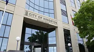
Kingston's headquarters are located at the 7-storey "1230 Nepean Hwy" building, which has become a landmark to Cheltenham as well as the council. The A-Grade office building was built in 1993.[11]
Schools
Primary education
- Aspendale Gardens Primary School
- Aspendale Primary School
- Bonbeach Primary School
- Carrum Primary School
- Chelsea Primary School
- Chelsea Heights Primary School
- Cheltenham East Primary School
- Clarinda Primary School
- Clayton South Primary School
- Dingley Primary School
- Edithvale Primary School
- Kingston Heath Primary School
- Kingswood Primary School
- Le Page Primary School
- Mentone Primary School
- Mentone Park Primary School
- Mordialloc Primary School
- Our Lady of the Assumption Catholic Primary School
- Parktone Primary School
- Parkdale Primary School
- Patterson Lakes Primary School
- Southmoor Primary School
- St Andrew's Catholic Primary School
- St Brigid's Catholic Primary School
- St Catherines Catholic Primary School
- St John Vianney's Catholic Primary School
- St Joseph's Catholic Primary School
- St Louis De Montforts Catholic Primary School
- St Mark's Primary School
- St Patrick's Catholic Primary School
Secondary education
Primary and secondary education
Railway stations
- Aspendale
- Aspendale railway station – April 1891
- Bonbeach
- Bonbeach railway station – February 1927
- Carrum
- Carrum railway station – August 1882
- Chelsea
- Chelsea railway station – February 1907
- Cheltenham
- Cheltenham railway station – December 1881
- Southland railway station – November 2017
- Clayton South
- Westall railway station – February 1951
- Edithvale
- Edithvale railway station – September 1919
- Highett
- Highett railway station – December 1881
- Mentone
- Mentone railway station – December 1881
- Moorabbin
- Moorabbin railway station – December 1881
- Mordialloc
- Mordialloc railway station – December 1881
- Parkdale
- Parkdale railway station – September 1919
Library services
The City of Kingston operates nine free council run libraries.[12]
Major branches
- Chelsea
- Cheltenham
- Clarinda
- Parkdale
- Westall
Minor branches
- Dingley
- Highett
- Moorabbin
- Patterson Lakes
Sport and recreation facilities
The City of Kingston operates two swimming and recreation centres:[13]
- The Waves Leisure Centre which has a 50-metre swimming pool, spa, gym and separate wave pool.
- The Don Tatnell Leisure Centre which has a 25-metre swimming pool, spa and gym.
References
- "3218.0 – Regional Population Growth, Australia, 2017–18: Population Estimates by Local Government Area (ASGS 2018), 2017 to 2018". Australian Bureau of Statistics. Australian Bureau of Statistics. 27 March 2019. Retrieved 25 October 2019. Estimated resident population, 30 June 2018.
- "Kingston City Council – Local Government Victoria – Department for Victorian Communities". Find your local council. Department for Victorian Communities. 24 January 2007. Archived from the original on 3 September 2007. Retrieved 20 July 2007.
- "City of Kingston 2019-20 Annual Report". City of Kingston. Retrieved 29 January 2021.
- "Five re-elected to expanded council". baysidenews.com.au. Bayside News. 30 December 2020. Retrieved 6 December 2020.
- "Council Wards". City of Kingston. Retrieved 4 December 2020.
- "Tracking Victorian Crs who are members of a political party". The Mayne Report. Retrieved 23 June 2020.
- {https://www.maynereport.com/articles/2016/10/24-0943-8109.html |website=The Mayne Report |accessdate=23 June 2020}}]]|accessdate=8 November 2020}}
- {https://www.maynereport.com/articles/2016/10/24-0943-8109.html |website=The Mayne Report |accessdate=23 June 2020}}]]|accessdate=8 November 2020}}
- {https://www.maynereport.com/articles/2016/10/24-0943-8109.html |website=The Mayne Report |accessdate=23 June 2020}}]]|accessdate=8 November 2020}}
- Kingston City Council (18 July 2007). "Budget for Kingston Council 2007–08". Archived from the original on 27 September 2007. Retrieved 20 July 2007.
- "Archived copy". Archived from the original on 23 July 2011. Retrieved 5 March 2011.CS1 maint: archived copy as title (link)
- "Archived copy". Archived from the original on 2 April 2011. Retrieved 19 April 2011.CS1 maint: archived copy as title (link)
- "Archived copy". Archived from the original on 17 March 2012. Retrieved 5 January 2012.CS1 maint: archived copy as title (link)
External links
- Kingston City Council
- Kingston Historical Website, in particular The Battle for Local Government: The Severance of Mordialloc from Moorabbin in 1920
- Department for Victorian Communities Kingston City Council Municipality Profile (includes ward map)
- Metlink local public transport for City of Kingston
- Link to Land Victoria interactive maps