Shire of Yarriambiack
The Shire of Yarriambiack is a local government area of Victoria, Australia, located in the north-western part of the state. It covers an area of 7,326 square kilometres (2,829 sq mi) and, in June 2018, had a population of 6,658,[1] having fallen from 7,438 in 2008.[3] It includes the towns of Hopetoun, Murtoa, Rupanyup and Warracknabeal. It was formed in 1995 from the amalgamation of the Shire of Warracknabeal, Shire of Karkarooc, and parts of the Shire of Dunmunkle and Shire of Wimmera.[2]
| Shire of Yarriambiack Victoria | |||||||||||||||
|---|---|---|---|---|---|---|---|---|---|---|---|---|---|---|---|
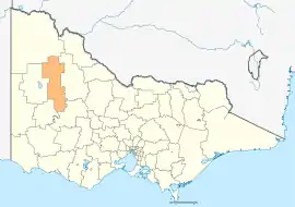 Location in Victoria | |||||||||||||||
| Population | 6,658 (2018)[1] | ||||||||||||||
| • Density | 0.90882/km2 (2.3538/sq mi) | ||||||||||||||
| Established | 1995 | ||||||||||||||
| Gazetted | 20 January 1995[2] | ||||||||||||||
| Area | 7,326 km2 (2,828.6 sq mi)[1] | ||||||||||||||
| Mayor | Cr Graeme Massey | ||||||||||||||
| Council seat | Warracknabeal | ||||||||||||||
| Region | Western Victoria | ||||||||||||||
| State electorate(s) | |||||||||||||||
| Federal Division(s) | Mallee | ||||||||||||||
| Website | Shire of Yarriambiack | ||||||||||||||
| |||||||||||||||
The Shire is governed and administered by the Yarriambiack Shire Council; its seat of local government and administrative centre is located at the council headquarters in Warracknabeal, it also has service centres located in Hopetoun and Rupanyup. The Shire is named after Yarriambiack Creek, a geographical feature that meanders through the LGA from the Wimmera River, through Warracknabeal, to Lake Coorong at Hopetoun.
Council
Current composition
The council is composed of three wards and seven councillors, with three councillors elected to represent the Warracknabeal Ward and two councillors per remaining ward elected to represent each of the other wards.[4]
| Ward | Councillor | Notes | |
|---|---|---|---|
| Dunmunkle | Corinne Heintze | ||
| Tom Hamilton | |||
| Hopetoun | Helen Ballentine | ||
| Shane Roberts | |||
| Warracknabeal | Graeme Massey | ||
| Jean Wise | |||
| Kylie Zanker | |||
Administration and governance

The council meets in the council chambers at the council headquarters in the Warracknabeal Municipal Offices, which is also the location of the council's administrative activities. It also provides customer services at both its administrative centre in Warracknabeal, and its service centres in Hopetoun and Rupanyup.
Main towns in shire
In June 2018 the shire had a population of 6,658.[1]
| Town | Population |
|---|---|
| Areegra | 35 |
| Aubrey | 10 |
| Bangerang | 57 |
| Beulah | 429 |
| Boolite | 37 |
| Brim | 171 |
| Cannum | 48 |
| Crymelon | 11 |
| Hopetoun | 739 |
| Kellalac | 17 |
| Kewell | 48 |
| Lah | 48 |
| Lascelles | 93 |
| Minyip | 524 |
| Murtoa | 865 |
| Patchewollock | 133 |
| Rosebery | 5 |
| Rupanyup | 536 |
| Sheep Hills | 28 |
| Speed | 78 |
| Tempy | 57 |
| Warracknabeal | 2,438 |
| Willenabrina | 9 |
| Woomelang | 201 |
| Yaapeet | 84 |
References
- "3218.0 – Regional Population Growth, Australia, 2017-18: Population Estimates by Local Government Area (ASGS 2018), 2017 to 2018". Australian Bureau of Statistics. Australian Bureau of Statistics. 27 March 2019. Retrieved 25 October 2019. Estimated resident population, 30 June 2018.
- Victoria Government Gazette – Online Archive (1837–1997). "S4 of 1995: Order estg (Part 16) the Shire of Yarriambiack". State Library of Victoria. State Government of Victoria (published 20 January 1995). p. 6. Retrieved 10 January 2014.
- "People: Population: ERP: ERP by LGA (ASGS 2018), 2001 to 2018". ABS.Stat. Australian Bureau of Statistics. 27 March 2019. Retrieved 29 November 2019.
- Local Government in Victoria. "Yarriambiack Shire Council". Department of Transport, Planning and Local Infrastructure. State Government of Victoria. Retrieved 10 January 2014.
External links
![]() Media related to Shire of Yarriambiack at Wikimedia Commons
Media related to Shire of Yarriambiack at Wikimedia Commons