Shire of Murrindindi
The Shire of Murrindindi is a local government area in the Hume region of Victoria, Australia, located in the north-east part of the state. It covers an area of 3,880 square kilometres (1,500 sq mi) and, in June 2018, had a population of 14,478.[1] It includes the towns of Alexandra, Buxton, Eildon, Flowerdale, Kinglake, Marysville, Molesworth, Strath Creek, Taggerty, Yarck and Yea. It was formed in 1994 from the amalgamation of the Shire of Alexandra, Shire of Yea, and parts of the Shire of Broadford, Shire of Eltham, Shire of Euroa, Shire of Healesville and City of Whittlesea.[2]
| Shire of Murrindindi Victoria | |||||||||||||||
|---|---|---|---|---|---|---|---|---|---|---|---|---|---|---|---|
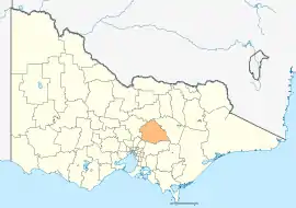 Location in Victoria | |||||||||||||||
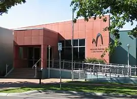 Council Offices in Alexandra | |||||||||||||||
| Population | 14,478 (2018)[1] | ||||||||||||||
| • Density | 3.731/km2 (9.664/sq mi) | ||||||||||||||
| Established | 1994 | ||||||||||||||
| Gazetted | 18 November 1994[2] | ||||||||||||||
| Area | 3,880 km2 (1,498.1 sq mi)[1] | ||||||||||||||
| Mayor | Leigh Dunscombe | ||||||||||||||
| Council seat | Alexandra | ||||||||||||||
| Region | Hume | ||||||||||||||
| State electorate(s) | Eildon | ||||||||||||||
| Federal Division(s) | Indi | ||||||||||||||
| Website | Shire of Murrindindi | ||||||||||||||
| |||||||||||||||
The Shire is governed by the Murrindindi Shire Council; its seat of local government and administrative centre is located at the council headquarters in Alexandra, it also has service centres located in Kinglake and Yea. The Shire is named after the locality of Murrindindi, which is located near the geographical centre of the LGA.
Parts of Murrindindi were badly affected by the 2009 Victorian bushfires, notably the towns of Marysville and Kinglake. In total, 106 people lost their lives across the Shire including 38 in Kinglake and 34 in Marysville.
Council
Current composition
The council is composed of seven wards and seven councillors, with one councillor elected to represent each ward.[3]
| Ward | Councillor | Notes | ||
|---|---|---|---|---|
| Cathedral | Sandice McAuley | |||
| Cheviot | Rebecca Bowles | |||
| Eildon | Jackie Ashe | |||
| King Parrot | Eric Lording | |||
| Kinglake | Leigh Dunscombe | Current Mayor | ||
| Koriella | Charlotte (Charlie) Bisset | |||
| Red Gate | Margaret Rae | Current Deputy Mayor | ||
Administration and governance
The council meets in the council chambers at the council headquarters in the Alexandra Municipal Offices, alternating with the Yea Council Chamber. It provides customer services at its administrative centre in Alexandra, and its service centres in Kinglake and Yea and a mobile Customer Service Centre.
Media
Murrindindi Shire activities are covered weekly by The Alexandra Standard and Yea Chronicle. Also, in print and online by The Local Paper.
UGFM Radio Murrindindi the main radio station based in the town of Alexandra and it airs around the Murrindindi Shire and its also available anywhere via internet.
Main towns in shire
In June 2018 the shire had a population of 14,478.[1]
| Population | |
| Locality | Total |
| Acheron | 171 |
| Alexandra | 2,695 |
| Buxton | 492 |
| Castella | 268 |
| Cathkin | 25 |
| Caveat | 41 |
| Cheviot | 0 |
| Devils River | 14 |
| Dropmore | 8 |
| Population | |
| Locality | Total |
| Eildon | 974 |
| Enochs Point | 0 |
| Fawcett | 60 |
| Flowerdale | 689 |
| Ghin Ghin | 41 |
| Glenburn | 415 |
| Gobur | 85 |
| Hazeldene | 247 |
| Highlands | 122 |
| Population | |
| Locality | Total |
| Homewood | 54 |
| Kanumbra | 59 |
| Kerrisdale | 73 |
| Killingworth | 106 |
| Kinglake | 1,536 |
| Kinglake Central | 345 |
| Kinglake West | 1,166 |
| Koriella | 60 |
| Limestone | 82 |
| Population | |
| Locality | Total |
| Maintongoon | 60 |
| Marysville | 394 |
| Molesworth | 72 |
| Murrindindi | 107 |
| Narbethong | 205 |
| Pheasant Creek | 322 |
| Rubicon | 56 |
| Strath Creek | 164 |
| Taggerty | 328 |
See also

References
- "3218.0 – Regional Population Growth, Australia, 2017-18: Population Estimates by Local Government Area (ASGS 2018), 2017 to 2018". Australian Bureau of Statistics. Australian Bureau of Statistics. 27 March 2019. Retrieved 25 October 2019. Estimated resident population, 30 June 2018.
- Victoria Government Gazette – Online Archive (1837–1997). "S87 of 1994. Order estg (Part 9) the Shire of Murrindindi". State Government of Victoria (published 18 November 1994). p. 4. Retrieved 10 January 2014.
- Local Government in Victoria. "Murrindindi Shire Council". Department of Transport, Planning and Local Infrastructure. State Government of Victoria. Retrieved 10 January 2014.
