Shire of Moira
The Shire of Moira is a local government area in the Hume region of Victoria, Australia, located in the north-east part of the state. It covers an area of 4,046 square kilometres (1,562 sq mi) and in June 2018 had a population of 29,799.[1]
| Moira Shire Council Victoria | |||||||||||||||
|---|---|---|---|---|---|---|---|---|---|---|---|---|---|---|---|
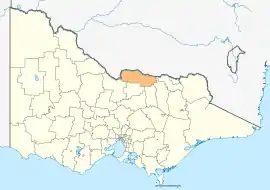 Location in Victoria | |||||||||||||||
| Population | 29,799 (2018)[1] | ||||||||||||||
| • Density | 7.3651/km2 (19.0754/sq mi) | ||||||||||||||
| Established | 1994 | ||||||||||||||
| Gazetted | 18 November 1994[2] | ||||||||||||||
| Area | 4,046 km2 (1,562.2 sq mi)[1] | ||||||||||||||
| Mayor | Cr Libro Mustica | ||||||||||||||
| Council seat | Cobram | ||||||||||||||
| Region | Hume | ||||||||||||||
| State electorate(s) | |||||||||||||||
| Federal Division(s) | |||||||||||||||
| Website | Moira Shire Council | ||||||||||||||
| |||||||||||||||
It includes the towns of Cobram, Nathalia, Numurkah, Tungamah and Yarrawonga. It was formed in 1994 from the amalgamation of the Shire of Cobram, Shire of Nathalia, Shire of Numurkah, and parts of the Shire of Tungamah and Shire of Yarrawonga.[2]
The Shire is governed and administered by the Moira Shire Council; its seat of local government and administrative centre is located at the council headquarters in Cobram, it also has service centres located in Numurkah and Yarrawonga. The Shire is named after the county of Moira, of which the LGA occupies the northern part.
Council
Current composition
The council is composed of nine councillors elected to represent an unsubdivided municipality.[3]
| Ward | Councillor | Notes | |
|---|---|---|---|
| Unsubdivided | Kevin Bourke | ||
| Wendy Buck | |||
| Gary Cleveland | |||
| Edward Cox | |||
| Libro Mustica | Mayor 2017/18 | ||
| Peter Mansfield | |||
| Marie Martin | |||
| John Beitzel | |||
| Peter Lawless | |||
Administration and governance
The council meets in various locations around the Shire. It also provides customer services at both its administrative centre in Cobram and its service centre in Yarrawonga.
Main towns in shire
In June 2018 the shire had a population of 29,799.[1]
| Town | Population |
|---|---|
| Almonds | 26 |
| Barmah | 282 |
| Bathumi | 62 |
| Bearii | 145 |
| Boomahnoomoonah | 22 |
| Boosey | 105 |
| Boweya North | 43 |
| Bundalong | 428 |
| Bundalong South | 51 |
| Burramine | 197 |
| Burramine South | 24 |
| Cobram | 6,014 |
| Cobram East | 242 |
| Drumanure | 41 |
| Esmond | 9 |
| Invergordon | 610 |
| Kaarimba | 85 |
| Katamatite | 402 |
| Katamatite East | 35 |
| Katunga | 996 |
| Koonoomoo | 296 |
| Kotupna | 105 |
| Lake Rowan | 66 |
| Lower Moira | 25 |
| Marungi | 111 |
| Muckatah | 213 |
| Mundoona | 119 |
| Mywee | 14 |
| Naring | 120 |
| Nathalia | 1,880 |
| Numurkah | 4,477 |
| Peechelba | 184 |
| Pelluebla | 33 |
| Picola | 207 |
| Picola West | 9 |
| St James | 132 |
| Strathmerton | 1,052 |
| Telford | 24 |
| Tungamah | 408 |
| Ulupna | 23 |
| Waaia | 390 |
| Waggarandall | 40 |
| Wilby | 166 |
| Wunghnu | 334 |
| Yabba North | 101 |
| Yabba South | 27 |
| Yalca | 206 |
| Yarrawonga | 7,930 |
| Yarrawonga South | 15 |
| Yarroweyah | 548 |
| Yielima | 87 |
| Youanmite | 59 |
| Youarang | 39 |
| Yundool | 44 |
References
- "3218.0 – Regional Population Growth, Australia, 2017-18: Population Estimates by Local Government Area (ASGS 2018), 2017 to 2018". Australian Bureau of Statistics. Australian Bureau of Statistics. 27 March 2019. Retrieved 25 October 2019. Estimated resident population, 30 June 2018.
- Victoria Government Gazette – Online Archive (1837–1997). "S87 of 1994: Order estg (Part 11) the Shire of Moira". State Library of Victoria. State Government of Victoria (published 18 November 1994). p. 4. Retrieved 10 January 2014.
- Local Government in Victoria. "Moira Shire Council". Department of Transport, Planning and Local Infrastructure. State Government of Victoria. Retrieved 10 January 2014.
External links
- Moira Shire Council official website
- Metlink local public transport map
- Link to Land Victoria interactive maps
