Shire of Northern Grampians
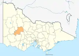
The Shire of Northern Grampians is a local government area in the Wimmera region of Victoria, Australia, located in the western part of the state. It covers an area of 5,730 square kilometres (2,210 sq mi) and in June 2018 had a population of 11,431,[1] having fallen from 12,087[3] in 2008. It includes the towns of Stawell, St Arnaud, Great Western, Marnoo, Glenorchy, Stuart Mill, Navarre and the tourist town of Halls Gap. It was formed in 1995 from the amalgamation of the City of Stawell, Town of St Arnaud, Shire of Stawell, Shire of Kara Kara and parts of the Shire of Wimmera, Shire of Dunmunkle and Shire of Donald.[2]
| Shire of Northern Grampians Victoria | |||||||||||||||
|---|---|---|---|---|---|---|---|---|---|---|---|---|---|---|---|
 Location in Victoria | |||||||||||||||
| Population | 11,431 (2018)[1] | ||||||||||||||
| • Density | 1.9949/km2 (5.167/sq mi) | ||||||||||||||
| Established | 1995 | ||||||||||||||
| Gazetted | 20 January 1995[2] | ||||||||||||||
| Area | 5,730 km2 (2,212.4 sq mi)[1] | ||||||||||||||
| Mayor | Cr Kevin Erwin | ||||||||||||||
| Council seat | Stawell | ||||||||||||||
| Region | Western Victoria | ||||||||||||||
| State electorate(s) | |||||||||||||||
| Federal Division(s) | Mallee | ||||||||||||||
| Website | Shire of Northern Grampians | ||||||||||||||
| |||||||||||||||
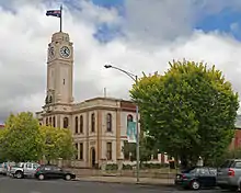
The Shire is governed and administered by the Northern Grampians Shire Council; its seat of local government and administrative centre is located at the council headquarters in Stawell, it also has a service centre located in St Arnaud. The Shire is named after the major geographical feature in the region, The Grampians, and that the northern part of this feature occupies the southern part of the LGA.
The local economy is based on a diverse range of industries including agriculture, tourism, wine production, gold mining, brick manufacturing and meat production.
Council
Current composition
The council is composed of four wards and seven councillors, with three councillors elected to represent the Stawell Ward, two councillors elected to represent the Kara Kara Ward and one councillor per remaining ward elected to represent each of the other wards.[4]
| Ward | Councillor | Notes | |
|---|---|---|---|
| Central | Kevin Erwin | ||
| Kara Kara | Merrilee Reid | ||
| Tony Driscoll | Mayor (2016–18) | ||
| South West | Paul Russell | ||
| Stawell | Murray Emerson | ||
| Karen Hyslop | |||
| Wayne Rice | |||
Administration and governance
The council meets in the council chambers at the council headquarters in the Stawell Town Hall Offices, which is also the location of the council's administrative activities. It also provides customer services at both its administrative centre in Stawell, and its service centre in St Arnaud.
Main towns in shire
In June 2018 the shire had a population of 11,413.[1]
| Town | Population |
|---|---|
| Dadswell Bridge | 71 |
| Glenorchy | 125 |
| Great Western | 400 |
| Halls Gap | 430 |
| Marnoo | 122 |
| Navarre | 98 |
| St Arnaud | 2,193 |
| Stawell | 6,032 |
| Stuart Mill | 79 |
See also
List of localities (Victoria)
References
- "3218.0 – Regional Population Growth, Australia, 2017-18: Population Estimates by Local Government Area (ASGS 2018), 2017 to 2018". Australian Bureau of Statistics. Australian Bureau of Statistics. 27 March 2019. Retrieved 25 October 2019. Estimated resident population, 30 June 2018.
- Victoria Government Gazette – Online Archive (1837–1997). "S4 of 1995: Order estg (Part 11) the Shire of Northern Grampians". State Library of Victoria. State Government of Victoria (published 20 January 1995). pp. 4–5. Retrieved 10 January 2014.
- "People: Population: ERP: ERP by LGA (ASGS 2018), 2001 to 2018". ABS.Stat. Australian Bureau of Statistics. 27 March 2019. Retrieved 29 November 2019.
- Local Government in Victoria. "Northern Grampians Shire Council". Department of Transport, Planning and Local Infrastructure. State Government of Victoria. Retrieved 10 January 2014.
External links
- Northern Grampians Shire Council official website
- Metlink local public transport map
- Link to Land Victoria interactive maps