Shire of Colac Otway
The Shire of Colac Otway is a local government area in the Barwon South West region of Victoria, Australia, located in the south-western part of the state. It covers an area of 3,438 square kilometres (1,327 sq mi) and in June 2018 had a population of 21,503.[1] It includes the towns of Apollo Bay, Beeac, Beech Forest, Birregurra, Colac, Cressy, Forrest, Johanna, Kennett River, Lavers Hill, Warrion and Wye River. It was formed in 1994 from the amalgamation of the City of Colac, Shire of Colac, Shire of Otway and part of the Shire of Heytesbury.[2]
| Shire of Colac Otway Victoria | |||||||||||||||
|---|---|---|---|---|---|---|---|---|---|---|---|---|---|---|---|
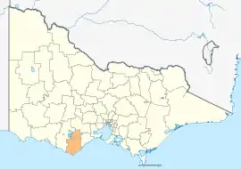 Location in Victoria | |||||||||||||||
| Population | 21,503 (2018)[1] | ||||||||||||||
| • Density | 6.2545/km2 (16.1991/sq mi) | ||||||||||||||
| Established | 1994 | ||||||||||||||
| Gazetted | 23 September 1994[2] | ||||||||||||||
| Area | 3,438 km2 (1,327.4 sq mi)[1] | ||||||||||||||
| Mayor | Cr Jason Schram | ||||||||||||||
| Council seat | Colac | ||||||||||||||
| Region | Barwon South West | ||||||||||||||
| State electorate(s) | Polwarth | ||||||||||||||
| Federal Division(s) | Corangamite | ||||||||||||||
| Website | Shire of Colac Otway | ||||||||||||||
| |||||||||||||||
The Shire is governed and administered by the Colac Otway Shire Council; its seat of local government and administrative centre is located at the council headquarters in Colac, it also has a service centre located in Apollo Bay. The Shire is named after the combination of the names for the former City of Colac, and Shires of Colac and Otway, of which the majority of the LGA was formed from. The name Colac is used for both the main urban settlement and the lake, Lake Colac, which are located in the north-centre of the LGA. Colac is also the most populous urban centre in the LGA with a population of almost 12,000.[3] The name Otways is used for the major geographical features located in the south of the LGA, which are The Otways and Cape Otway. Cape Otway was originally named by Lieutenant James Grant who was the commander of the vessel, the Lady Nelson.[4] He named it after Captain William Otway who was one of the commissioners of the Transport Board, on 7 December 1800.[4]
History
The Colac district is the traditional land for the Gulidjan people and was known as “Kolak” or “Kolakgnat” which means ‘belonging to sand’.[5] The Gulidjan people are of the Easter Maar Nation.[5]
The earliest European settlers arrived in the district in the 1830s and settled around Lake Colac.[6]
Council
Current composition
The council is composed of seven councillors elected to represent an unsubdivided municipality. In order of election in 2020, they are:[7]
| Ward | Party | Councillor | Notes | |
|---|---|---|---|---|
| Unsubdivided | Independent | Joe McCracken | ||
| Independent | Chris Potter | |||
| Labor | Graham Lesie Costin | |||
| Independent | Kate Hanson | |||
| Greens | Stephen Hart | |||
| Independent | Jamie Bell | |||
| Independent | Margaret White | |||
Former Wards (1996–2008)
- Colac – had three councillors
- Murray – had one councillor
- Otway – had one councillor
- Warrion – had one councillor
Administration and governance
The council meets in the council chambers at the council headquarters in the Colac Municipal Offices, which is also the location of the council's administrative activities. It also provides customer services at both its administrative centre in Colac, and its service centre in Apollo Bay.
Main towns in shire
In June 2018 the shire had a population of 21,503.[1]
| Population | |
| Locality | Total |
| Alvie | 132 |
| Apollo Bay | 1,598 |
| Balintore | 67 |
| Barongarook | 434 |
| Barongarook West | 235 |
| Barwon Downs | 131 |
| Beeac | 370 |
| Beech Forest | 82 |
| Birregurra | 828 |
| Bungador | 62 |
| Cape Otway | 15 |
| Carlisle River | 135 |
| Population | |
| Locality | Total |
| Carpendeit | 134 |
| Chapple Vale | 36 |
| Colac | 12,547 |
| Coragulac | 161 |
| Cororooke | 310 |
| Corunnun | 115 |
| Cressy | 175 |
| Dreeite | 55 |
| Dreeite South | 30 |
| Eurack | 65 |
| Ferguson | 19 |
| Forrest | 230 |
| Population | |
| Locality | Total |
| Gellibrand | 210 |
| Irrewarra | 345 |
| Irrewillipe | 125 |
| Johanna | 63 |
| Kawarren | 166 |
| Kennett River | 41 |
| Larpent | 194 |
| Lavers Hill | 78 |
| Marengo | 239 |
| Pirron Yallock | 113 |
| Skenes Creek | 164 |
| Stonyford | 51 |
| Population | |
| Locality | Total |
| Swan Marsh | 121 |
| Warncoort | 130 |
| Warrion | 198 |
| Weeaproinah | 11 |
| Weering | 67 |
| Wongarra | 37 |
| Wool Wool | 38 |
| Wye River | 63 |
| Wyelangta | 38 |
| Yeo | 148 |
| Yeodene | 121 |
| Yuulong | 37 |
References
- "3218.0 – Regional Population Growth, Australia, 2017-18: Population Estimates by Local Government Area (ASGS 2018), 2017 to 2018". Australian Bureau of Statistics. Australian Bureau of Statistics. 27 March 2019. Retrieved 25 October 2019. Estimated resident population, 30 June 2018.
- Victoria Government Gazette – Online Archive (1837–1997). "S63 of 1994: Order estg (Part 2) the Shire of Colac-Otway". State Library of Victoria. State Government of Victoria (published 23 September 1994). p. 3. Retrieved 10 January 2014.
- Census QuickStats (2016). "Colac (UCL) – UCL213003". Australian Bureau of Statistics. Government of Australia. Retrieved 10 December 2017.
- "Otways and Otway Shire". Victorian Places. Retrieved 5 September 2020.
- "About Colac Otway". Colac Otway Shire. Retrieved 19 July 2020.
- "A short history of Colac". Colac & District Historical Society. Retrieved 19 July 2020.
- "Colac Otway Shire Council election results 2020". www.vec.vic.gov.au. Retrieved 8 November 2020.
External links
![]() Media related to Shire of Colac Otway at Wikimedia Commons
Media related to Shire of Colac Otway at Wikimedia Commons