Saint-Quentin Parish, New Brunswick
Saint-Quentin is a civil parish in Restigouche County, New Brunswick, Canada.[2]
Saint-Quentin
St. Quentin | |
|---|---|
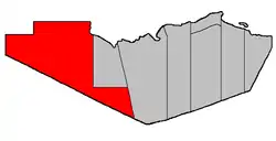 Location within Restigouche County. | |
| Coordinates: 47.76°N 67.8425°W | |
| Country | |
| Province | |
| County | Restigouche |
| Erected | 1921 |
| Area | |
| • Land | 2,478.57 km2 (956.98 sq mi) |
| Population (2016)[1] | |
| • Total | 1,532 |
| • Density | 0.6/km2 (2/sq mi) |
| • Change 2011-2016 | |
| • Dwellings | 696 |
| Time zone | UTC-4 (AST) |
| • Summer (DST) | UTC-3 (ADT) |
For governance purposes it is divided between the town of Saint-Quentin and the local service districts of St. Martin de Restigouche and the parish of Saint-Quentin,[3] all of which are members of the Northwest Regional Service Commission (NWRSC).[4]
Origin of name
The parish was named for the Battle of St. Quentin, an Allied victory during the First World War.[5]
History
Saint-Quentin was erected in 1921 from Grimmer Parish.[6]
Delineation
Saint-Quentin Parish is defined in the Territorial Division Act[2] as being bounded:
- On the north by the Parish of Grimmer and the Province of Quebec; on the west by the Province of Quebec; on the southwest by the Counties of Victoria and Madawaska, and on the east by the Parishes of Grimmer and Eldon.
Communities
Parish population total does not include incorporated municipalities (in bold).
|
|
Demographics
Population
| Canada census – Saint-Quentin Parish, New Brunswick community profile | |||
|---|---|---|---|
| 2016 | 2011 | 2006 | |
| Population: | 1,532 (+2.9% from 2011) | 1,489 (-5.6% from 2006) | 1,578 (+1.3% from 2001) |
| Land area: | 2,478.57 km2 (956.98 sq mi) | 2,478.88 km2 (957.10 sq mi) | 2,478.88 km2 (957.10 sq mi) |
| Population density: | 0.6/km2 (1.6/sq mi) | 0.6/km2 (1.6/sq mi) | 0.6/km2 (1.6/sq mi) |
| Median age: | 46.8 (M: 47.5, F: 46.0) | 44.7 (M: 44.4, F: 45.0) | 39.9 (M: 40.7, F: 38.6) |
| Total private dwellings: | 696 | 642 | 732 |
| Median household income: | $59,776 | $.N/A | $41,384 |
| Notes: Data for this area has been suppressed for data quality or confidentiality reasons. – References: 2016[7] 2011[8] 2006[9] earlier[10] | |||
|
|
| |||||||||||||||||||||||||||
| [11][1] | |||||||||||||||||||||||||||||
Language
| Canada Census Mother Tongue - Saint-Quentin Parish, New Brunswick[11][1] | ||||||||||||||||||
|---|---|---|---|---|---|---|---|---|---|---|---|---|---|---|---|---|---|---|
| Census | Total | French |
English |
French & English |
Other | |||||||||||||
| Year | Responses | Count | Trend | Pop % | Count | Trend | Pop % | Count | Trend | Pop % | Count | Trend | Pop % | |||||
2016 |
1,520 |
1,495 | 98.4% | 15 | 1.0% | 5 | 0.3% | 5 | 0.3% | |||||||||
2011 |
1,480 |
1,450 | 97.97% | 20 | 1.35% | 5 | 0.34% | 5 | 0.34% | |||||||||
2006 |
1,585 |
1,435 | 90.54% | 70 | 4.42% | 0 | 0.00% | 80 | 5.05% | |||||||||
2001 |
1,540 |
1,530 | 99.35% | 0 | 0.00% | 10 | 0.65% | 0 | 0.00% | |||||||||
1996 |
0 |
1,515 | n/a | 0.00% | 35 | n/a | 0.00% | 0 | n/a | 0.00% | 0 | n/a | 0.00% | |||||
Access Routes
Highways and numbered routes that run through the parish, including external routes that start or finish at the parish limits:[12]
See also
References
- "Census Profile, 2016 Census: Saint-Quentin, Parish [Census subdivision], New Brunswick". Statistics Canada. Retrieved September 28, 2019.
- "Chapter T-3 Territorial Division Act". Government of New Brunswick. Retrieved 13 November 2020.
- "New Brunswick Regulation 84-168 under the Municipalities Act (O.C. 84-582)". Government of New Brunswick. Retrieved 22 July 2020.
- "Communities in each of the 12 Regional Service Commissions (RSC) / Les communautés dans chacune des 12 Commissions de services régionaux (CSR)" (PDF), Government of New Brunswick, July 2017, retrieved 2 February 2021
- "Saint-Quentin Parish". Provincial Archives of New Brunswick. Retrieved 23 October 2020.
- "11 Geo. V c. 18 An Act to Amend Chapter 2 of the Consolidated Statutes, 1903, respecting the division of the Province into Counties, Towns and Parishes.". Acts of the Legislative Assembly of New Brunswick Passed in the Month of April 1921. Fredericton: Government of New Brunswick. 1921. pp. 155–166.
- "2016 Community Profiles". 2016 Canadian Census. Statistics Canada. February 21, 2017. Retrieved 2019-09-28.
- "2011 Community Profiles". 2011 Canadian Census. Statistics Canada. July 5, 2013. Retrieved 2014-03-21.
- "2006 Community Profiles". 2006 Canadian Census. Statistics Canada. March 30, 2011. Retrieved 2014-03-21.
- "2001 Community Profiles". 2001 Canadian Census. Statistics Canada. February 17, 2012.
- Statistics Canada: 1996, 2001, 2006, 2011 census
- Atlantic Canada Back Road Atlas ISBN 978-1-55368-618-7 Pages 12-13
Places adjacent to Saint-Quentin Parish, New Brunswick | |
|---|---|
| Subdivisions | |
|---|---|
| Cities | |
| Counties | |
| |