Sainte-Anne Parish, New Brunswick
Sainte-Anne is a civil parish in Madawaska County, New Brunswick, Canada.[2]
Sainte-Anne
St. Anne, Ste. Anne | |
|---|---|
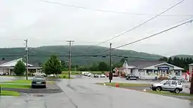 Sainte-Anne-de-Madawaska village | |
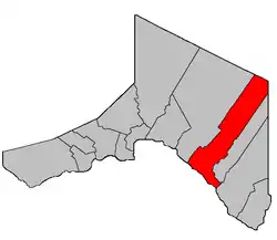 Location within Madawaska County, New Brunswick. | |
| Coordinates: 47.41°N 67.85°W | |
| Country | |
| Province | |
| County | Madawaska |
| Erected | 1877 |
| Area | |
| • Land | 368.89 km2 (142.43 sq mi) |
| Population (2016)[1] | |
| • Total | 964 |
| • Density | 2.6/km2 (7/sq mi) |
| • Change 2011-2016 | |
| • Dwellings | 509 |
| Time zone | UTC-4 (AST) |
| • Summer (DST) | UTC-3 (ADT) |
For governance purposes it is divided between the village of Sainte-Anne-de-Madawaska and the local service district of the parish of Sainte-Anne[3] (which further includes the special service area of Seigas),[3] both of which are members of the Northwest Regional Service Commission (NWRSC).[4]
Origin of name
The parish takes its name from the church.[5]
History
Sainte-Anne was erected in 1877 as Saint Ann's Parish from Saint-Basile and Saint-Léonard Parishes.[6]
In 1920 Sainte-Anne's boundaries were revised.[7] The same act erected Rivière-Verte Parish from Saint-Léonard, so part of Sainte-Anne may have been included in Rivière-Verte.
In 1922 Notre-Dame-de-Lourdes Parish was erected from part of Sainte-Anne.[8] The name appeared as Saint Ann in the description of Notre-Dame-de-Lourdes.
In 1946 the name was changed to Sainte Anne and the parish was affected by the major reorganisation of Madawaska County parish boundaries.[9]
In 1973 the name was legally changed to Sainte-Anne.[10]
Delineation
Sainte-Anne Parish is defined in the Territorial Division Act[2] as being bounded:
- Beginning at a point in the International Boundary where the same is intersected by the western prolongation of the southern limit of lot No. 99, granted to Andrew Michaud; thence in an easterly direction along said prolongation and said limit of said lot and the easterly prolongation of same to the southwest angle of lot No. 281, granted to Rosomo Violette; thence in a northerly direction along the east limit of the Reserved Road[lower-alpha 1] situated along the base line of the lots fronting on the St. John River to the northwest angle of lot No. 54, granted to J.P. Cyr; thence in an easterly direction along the north limit of said lot to a point in the west limit of lot No. 300, granted to Augustus Coté, in Tier Three; thence in a northerly direction along said limit of said lot to the northwest angle of the same; thence in a northeasterly direction along the north limit of said lot to the northeast angle of the same; thence in a northerly direction to the southeast angle of lot No. 52, granted to D. Mazerol; thence in said direction along the east limit of the lots in the Second Tier east of the St. John River to the northeast angle of lot No. 62, granted to Paul Cyr; thence in an easterly direction along the north limit of said lot to the northeast angle of the same; thence in a northerly and easterly direction following the north limit of the lots in Tier Four from lot No. 326 to lot No. 331, both inclusive, to a point where the east limit of the last-mentioned lot intersects the Siegas River; thence in an easterly and southeasterly direction following the various courses of said River upstream to a point where the same intersects the north limit of said lots in Tier Four; thence in an easterly and southerly direction along said limit of said lots to the southeast angle of lot No. 169 northeast, granted to Ed. Dube; thence in a northerly direction along the east limit of said lot to the southwest angle of lot No. 398; thence in an easterly direction along the south limit of said lot to a point in the west limit of lot No. 1, granted to James J. Dube, in Tier Four, Siegas Lake Settlement; thence in a southerly and easterly direction following the said bounds of lots Nos. 1 to 10 in said Tier Four of said Settlement to the southeast angle of the last-mentioned lot; thence in a northerly direction along the east limit of said lot to a point where the same is intersected by the western prolongation of the north limit of the lots in Siegas Lake Settlement; thence along said prolongation and said limit of said lots to a point in the west limit of lot No. 17, granted to Arsene Durette; thence in a northerly direction along said limit of said lot to a point in the south limit of lot No. 18, granted to D. Fournier, Tier Five, Siegas Lake Settlement; thence in an easterly direction along the south limit of said Tier Five of said Settlement to the southeast angle of lot No. 23, granted to Noel Ruest; thence in a northerly direction along the east limit of said lot to a point in the south limit of the Reserved Road[lower-alpha 2] between lots in Siegas Lake Settlement; thence in an easterly direction along said limit of said Reserved Road to a point in the east limit of the Third Tract, granted to the New Brunswick Railway Company; thence in a southerly direction along said limit of said Tract to a point where the same is intersected by the eastern prolongation of the south limit of lots Nos. 20 east to 23 east, both inclusive, in aforesaid Tier Five, Siegas Lake Settlement; thence in an easterly direction along said prolongation to a point in the Madawaska-Victoria County line; thence in a northerly direction along said County Line to the point of intersection with the Restigouche County Line; thence in a northwesterly direction along the last-mentioned County Line to a point where the same is intersected by the eastern prolongation of the north limit of the aforesaid Third Tract, granted to the New Brunswick Railway Company; thence in a westerly direction along said prolongation and said limit of said Tract to the northwest angle of the same; thence in a southerly direction along the west limit of said Tract to a point where the same is intersected by the southeast prolongation of the southern limit of lot No. 21, in Tier Nine, Côte-des-neiges;[lower-alpha 3] thence in a northwesterly direction along said prolongation said limit of said lot and said limit of lots Nos. 22, Tier Eight, and 123, Tier Seven, of aforesaid Settlement to the southwest angle of the last-mentioned lot; thence in a northerly direction along the west limit of said lot and said limit of lot No. 121 in said Tier Seven to the northwest angle of the last-mentioned lot; thence in a westerly direction crossing the Reserved Road[lower-alpha 4] between Tiers Six and Seven and along the south limit of lot No. 118 in said Tier Six to the southwest angle of said lot; thence in a northerly direction along the west limit of said Tier Six to a point where the same is intersected by the eastern prolongation of the division line between lots “I” and “G”, granted to John M. Stevens; thence in a westerly direction along said prolongation and said division line to the Quisibis River; thence in a northerly direction following the various courses of the said river upstream to the southeast angle of lot No. 10, granted to Amable Thibodeau; thence in a westerly direction along the south limit of said lot to the northeast angle of lot Letter “K” granted to John R. Lynch; thence in a westerly direction following the north limit of said lot to the east limit of the Reserved Road[lower-alpha 5] located along the base line of the St. John River lots; thence across said Reserved Road to the southeast angle of lot No. 38, granted to Francis Gaudin; thence in a westerly direction along the south limit of said lot and the western prolongation of same to a point in the International Boundary line; and thence in a southerly direction along said International Boundary line to the point of beginning.
Communities
Parish population total does not include incorporated municipalities (in bold):
|
|
Bodies of water
Bodies of water at least partly in the parish
- Saint John River
Demographics
Population
|
LanguageMother tongue (2016)[1]
|
Notes
References
- "Census Profile, 2016 Census: Sainte-Anne, Parish [Census subdivision], New Brunswick". Statistics Canada. Retrieved September 23, 2019.
- "Chapter T-3 Territorial Division Act". Government of New Brunswick. Retrieved 13 November 2020.
- "New Brunswick Regulation 84-168 under the Municipalities Act (O.C. 84-582)". Government of New Brunswick. Retrieved 19 July 2020.
- "Communities in each of the 12 Regional Service Commissions (RSC) / Les communautés dans chacune des 12 Commissions de services régionaux (CSR)" (PDF), Government of New Brunswick, July 2017, retrieved 2 February 2021
- Ganong, William F. (1896). A Monograph of the Place-Nomenclature of the Province of New Brunswick. Royal Society of Canada. p. 267.
- "41 Vic. c. 30 An Act to erect parts of the Parishes of Saint Leonard, Saint Basil, Madawaska, and Saint Francis, in the County of Madawaska, into three additional Parishes.". Acts of the General Assembly of Her Majesty's Province of New Brunswick. Passed in the Month of March 1877. Fredericton: Government of New Brunswick. 1877. pp. 125–128.
- "9 Geo. V c. 55 An Act to amend Chapter 2 of the Consolidated Statutes, 1903, respecting the division of the Province into Counties, Towns and Parishes.". Acts of the Legislative Assembly of New Brunswick Passed in the Month of April 1919. Fredericton: Government of New Brunswick. 1919. pp. 258–265.
- "11 Geo. V c. 18 An Act to Amend Chapter 2 of the Consolidated Statutes, 1903, respecting the division of the Province into Counties, Towns and Parishes.". Acts of the Legislative Assembly of New Brunswick Passed in the Month of April 1921. Fredericton: Government of New Brunswick. 1921. pp. 155–166.
- "10 Geo. VI. c. 95 An Act to amend Chapter 2 of the Revised Statutes, 1927, respecting the division of the Province into Counties, Towns and Parishes, in so far as it relates to the County of Madawaska.". Acts of the Legislative Assembly of New Brunswick Passed During the Session of 1946. Fredericton: Government of New Brunswick. 1946. pp. 321–339.
- "Chapter T-3 Territorial Division Act". Revised Statutes of New Brunswick 1973 Volume IV. Fredericton: Government of New Brunswick. 1973. pp. 1–70.
- "No. 143" (PDF). 2015 Designated Highway Maps. Government of New Brunswick. Retrieved 24 August 2016.
- Statistics Canada: 1996, 2001, 2006 census
- 2011 Statistics Canada Census Profile: Sainte-Anne Parish, New Brunswick
Places adjacent to Sainte-Anne Parish, New Brunswick | |
|---|---|
| Subdivisions | |
|---|---|
| Cities | |
| Counties | |
| |