Eldon Parish, New Brunswick
Eldon is a civil parish in Restigouche County, New Brunswick, Canada.[2]
Eldon | |
|---|---|
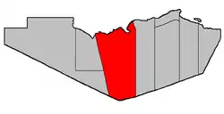 Location within Restigouche County. | |
| Coordinates: 47.75°N 67.075°W | |
| Country | |
| Province | |
| County | Restigouche |
| Erected | 1827 |
| Dissolved | 1879 |
| Reërected | 1896 |
| Area | |
| • Land | 1,681.46 km2 (649.22 sq mi) |
| Population (2016)[1] | |
| • Total | 657 |
| • Density | 0.4/km2 (1/sq mi) |
| • Change 2011-2016 | |
| • Dwellings | 360 |
| Time zone | UTC-4 (AST) |
| • Summer (DST) | UTC-3 (ADT) |
For governance purposes it is divided between the local service districts of Flatlands, Mann Mountain, St. Jean Baptiste – Menneval, White's Brook, and the parish of Eldon,[3] all of which are members of the Restigouche Regional Service Commission (RRSC).[4]
Origin of name
The parish was named in honour of the Earl of Eldon,[5] Lord High Chancellor of Great Britain at the time of its erection.
History
Eldon was erected in 1827 from Beresford Parish.[6] Eldon comprised Restigouche County west of the Upsalquitch River, with the county line being a prolongation of the western boundary of Northumberland County.
In 1840 the eastern boundary was altered to run due south from the mouth of the Upsalquitch.[7]
In 1852 the western county line was changed to its current location; Eldon's western line moved with it.[8]
In 1879 Eldon was dissolved and its territory added to Addington Parish.[9]
In 1896 Eldon was reërected from Addington, with the eastern line now further east in its modern configuration.[10]
In 1916 the western part of Eldon was erected as Grimmer Parish.[11] Grimmer included what is now Saint-Quentin Parish.
Delineation
Eldon Parish is defined in the Territorial Division Act[2] as being bounded:
- Northerly by the Province of Quebec Boundary line, easterly by a line beginning on the southern bank or shore of Restigouche River at the northwest angle of lot number twenty-two, granted to George Firth below Metapedia, thence southerly along the western line of said lot and its prolongation to the northeast angle of lot number one, in Dawsonville, thence continuing southerly along the eastern line of said lot number one and its southern prolongation, to the southeast angle of lot number two (Thomas Gracie) and thence true south to the County limits; southerly by the County line and westerly by a straight line extending from the Province of Quebec Boundary line in the Restigouche River, at the mouth of Upper Thorn Point Brook to Whites Brook railway station on the Canadian National Railways, and thence prolonged southerly to the Victoria County Boundary line.
Communities
All municipalities within Eldon Parish are unincorporated.
Demographics
Population
| Canada census – Eldon Parish, New Brunswick community profile | |||
|---|---|---|---|
| 2016 | 2011 | 2006 | |
| Population: | 657 (-5.9%% from 2011) | 698 (-10.4% from 2006) | 779 (-13.6% from 2001) |
| Land area: | 1,681.46 km2 (649.22 sq mi) | 1,681.54 km2 (649.25 sq mi) | 1,681.51 km2 (649.23 sq mi) |
| Population density: | 0.4/km2 (1.0/sq mi) | 0.4/km2 (1.0/sq mi) | 0.5/km2 (1.3/sq mi) |
| Median age: | 54.2 (M: 54.7, F: 53.6) | 52.0 (M: 51.8, F: 52.1) | 47.5 (M: 47.1, F: 47.7) |
| Total private dwellings: | 360 | 375 | 494 |
| Median household income: | $42,112 | $.N/A | $25,587 |
| Notes: 2011 income data for this area has been suppressed for data quality or confidentiality reasons. – References: 2016[12] 2011[13] 2006[14] earlier[15] | |||
|
|
| |||||||||||||||||||||||||||
| [16][1] | |||||||||||||||||||||||||||||
Language
| Canada Census Mother Tongue - Eldon Parish, New Brunswick[16] | ||||||||||||||||||
|---|---|---|---|---|---|---|---|---|---|---|---|---|---|---|---|---|---|---|
| Census | Total | English |
French |
English & French |
Other | |||||||||||||
| Year | Responses | Count | Trend | Pop % | Count | Trend | Pop % | Count | Trend | Pop % | Count | Trend | Pop % | |||||
2016 |
655 |
330 | 50.38% | 320 | 48.85% | 5 | 0.76% | 0 | 0.0% | |||||||||
2011 |
695 |
360 | 51.80% | 330 | 47.48% | 5 | 0.72% | 0 | 0.00% | |||||||||
2006 |
780 |
355 | 45.51% | 410 | 52.56% | 15 | 1.92% | 0 | 0.00% | |||||||||
2001 |
900 |
460 | 51.11% | 420 | 46.67% | 20 | 2.22% | 0 | 0.00% | |||||||||
1996 |
1,045 |
570 | n/a | 54.55% | 475 | n/a | 45.45% | 0 | n/a | 0.00% | 0 | n/a | 0.00% | |||||
Access Routes
Highways and numbered routes that run through the parish, including external routes that start or finish at the parish limits:[17]
References
- "Census Profile, 2016 Census: Eldon, Parish [Census subdivision], New Brunswick". Statistics Canada. Retrieved September 28, 2019.
- "Chapter T-3 Territorial Division Act". Government of New Brunswick. Retrieved 13 November 2020.
- "New Brunswick Regulation 84-168 under the Municipalities Act (O.C. 84-582)". Government of New Brunswick. Retrieved 22 July 2020.
- "Communities in each of the 12 Regional Service Commissions (RSC) / Les communautés dans chacune des 12 Commissions de services régionaux (CSR)" (PDF), Government of New Brunswick, July 2017, retrieved 2 February 2021
- Ganong, William F. (1896). A Monograph of the Place-Nomenclature of the Province of New Brunswick. Royal Society of Canada. p. 232.
- "7 Geo. IV c. 31 An Act for the division of the County of Northumberland into three Counties, and to provide for the Government and Representation of the two new Counties.". Acts of the General Assembly of His Majesty's Province of New-Brunswick, Passed in the Year 1827. Fredericton: Government of New Brunswick. 1827. pp. 97–103.
- "2 Vic. c. 19 An Act to divide the County of Restigouche into five Towns or Parishes and to define the boundaries thereof.". Acts of the General Assembly of Her Majesty's Province of New Brunswick, Passed in the Year 1839. Fredericton: Government of New Brunswick. 1839. pp. 63–64.
- "15 Vic. c. 6 An Act to annex the Territory awarded to this Province by the New Brunswick and Canadian Arbitrators in the recent settlement of the Boundary question between the Provinces of New Brunswick and Canada, to the Counties of Victoria and Restigouche, and to alter the present Boundary Line between these counties.". Acts of the General Assembly of Her Majesty's Province of New Brunswick, Passed in the Year 1852. Fredericton: Government of New Brunswick. 1852. pp. 4–5.
- "42 Vic. c. 57 An Act to extend the Parish of Addington, in the County of Restigouche.". Acts of the General Assembly of Her Majesty's Province of New Brunswick. Passed in the Month of April 1879. Fredericton: Government of New Brunswick. 1879. pp. 114–115.
- "59 Vic. c. 8 An Act to Revise and Codify an Act to Provide for the Division of the Province into Counties, Towns and Parishes.". Acts of the General Assembly of Her Majesty's Province of New Brunswick. Passed in the Month of March, 1896. Fredericton: Government of New Brunswick. 1896. pp. 86–123.
- "5 Geo. V c. 47 An Act to amend Chapter 2, Consolidated Statutes, 1903, so far as it relates to the Parish of Eldon, in the County of Restigouche.". Acts of the Legislative Assembly of New Brunswick Passed in the Months of April and May 1915. Fredericton: Government of New Brunswick. 1915. pp. 432–434.
- "2016 Community Profiles". 2016 Canadian Census. Statistics Canada. February 21, 2017. Retrieved 2019-09-28.
- "2011 Community Profiles". 2011 Canadian Census. Statistics Canada. July 5, 2013. Retrieved 2014-03-21.
- "2006 Community Profiles". 2006 Canadian Census. Statistics Canada. March 30, 2011. Retrieved 2014-03-21.
- "2001 Community Profiles". 2001 Canadian Census. Statistics Canada. February 17, 2012.
- Statistics Canada: 1996, 2001, 2006, 2011 census
- Atlantic Canada Back Road Atlas ISBN 978-1-55368-618-7 Pages 4-5, 12-13
Places adjacent to Eldon Parish, New Brunswick | |
|---|---|
| Subdivisions | |
|---|---|
| Cities | |
| Counties | |
| |