Rivière-Verte Parish, New Brunswick
Rivière-Verte is a civil parish in Madawaska County, New Brunswick, Canada.[2]
Rivière-Verte | |
|---|---|
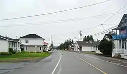 Rivière-Verte village | |
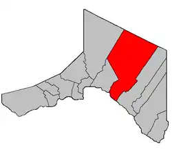 Location within Madawaska County. | |
| Coordinates: 47°19′N 68°09′W | |
| Country | |
| Province | |
| County | Madawaska |
| Erected | 1920 |
| Area | |
| • Land | 715.86 km2 (276.40 sq mi) |
| Population (2016)[1] | |
| • Total | 711 |
| • Density | 1.0/km2 (3/sq mi) |
| • Change 2011-2016 | |
| • Dwellings | 346 |
| Time zone | UTC-4 (AST) |
| • Summer (DST) | UTC-3 (ADT) |
For governance purposes it is divided between the village of Rivière-Verte and the local service district of the parish of Rivière-Verte,[3] both of which are members of the Northwest Regional Service Commission (NWRSC).[4]
Origin of name
The parish probably takes its name from the Green River, a tributary of the Saint John River, which takes its name from the colour of its water.[5]
History
Rivière-Verte was erected in 1920 from Saint-Basile Parish.[6]
Delineation
Rivière-Verte Parish is defined in the Territorial Division Act[2] as being bounded:
- All that part of the above described Parish of Saint-Basile, lying easterly of the described lines, namely: beginning at a point on the northern side of the Saint John River in the division line between the lots now owned and occupied by Ubalde Theriault, and Victor R. Cyr, thence following the said division line to the rear line of the St. John River lots, then following said rear line of the St. John River lots in a westerly direction till it strikes the lower line of lot No. 10, granted to James Smith, said lot No. 10 is lying between the rear line of the St. John River lots and Green River,[lower-alpha 1] thence following said lower line of Lot No. 10 to the westerly side of Green River, thence across said Green River in a direct line to the southeasterly side of line lot No. 17, granted to Felix Martin, thence following said southeasterly side of said lot No. 17 till it strikes the rear line of lots of the first tier east of said Green River, thence in a northerly direction till it strikes the division line between lots No. 6 and 7 in tier second of said Green River, thence following said last division line till it strikes the rear line of lots in second tier east of said Green River, thence following the division line between lots No. 17 and 18 in the third tier east of said Green River, and thence following the division line between lots 21 and 22 in fourth tier east of said Green River till it strikes the rear line of lots in said fourth tier, thence following the rear line of lots in tier four in a northerly direction by a straight line to the boundary line between the Parishes of Madawaska and Saint-Basile, thence following said division line between the said Parishes of Madawaska and Saint-Basile to the Restigouche County line, thence following the said Restigouche County line to the westerly side of the division line between the Parishes of Sainte-Anne and Saint-Basile, thence following the said last division line to the Saint John River, and thence following up the said Saint John River to the place of beginning.
Communities
Parish population total does not include incorporated municipalities (in bold) and communities within their respective boundaries (in italics).
- Beardsley Depot
- Davis Mill
- Montagne-de-la-Croix
- Montagne-des-Roy
- Rang-des-Hubert
- Rivière-Verte
Bodies of water
Bodies of water at least partly in the parish
- Saint John River
Demographics
Population
| Canada census – Rivière-Verte Parish, New Brunswick community profile | |||
|---|---|---|---|
| 2016 | 2011 | 2006 | |
| Population: | 711 (+3.6% from 2011) | 686 (-13.3% from 2006) | 791 (-4.1% from 2001) |
| Land area: | 715.86 km2 (276.40 sq mi) | 715.60 km2 (276.29 sq mi) | 715.58 km2 (276.29 sq mi) |
| Population density: | 1.0/km2 (2.6/sq mi) | 1.0/km2 (2.6/sq mi) | 1.1/km2 (2.8/sq mi) |
| Median age: | 47.1 (M: 48.3, F: 43.9) | 45.2 (M: 44.9, F: 45.6) | 41.5 (M: 41.4, F: 41.5) |
| Total private dwellings: | 346 | 325 | 471 |
| Median household income: | $47,616 | $44,379 | $36,680 |
| References: 2016[7] 2011[8] 2006[9] earlier[10] | |||
|
|
| |||||||||||||||||||||||||||
| [11][1] | |||||||||||||||||||||||||||||
Language
| Canada Census Mother Tongue - Rivière-Verte Parish, New Brunswick[11] | ||||||||||||||||||
|---|---|---|---|---|---|---|---|---|---|---|---|---|---|---|---|---|---|---|
| Census | Total | French |
English |
French & English |
Other | |||||||||||||
| Year | Responses | Count | Trend | Pop % | Count | Trend | Pop % | Count | Trend | Pop % | Count | Trend | Pop % | |||||
2016 |
705 |
690 | 97.9% | 10 | 1.4% | 5 | 0.7% | 0 | 0% | |||||||||
2011 |
685 |
675 | 98.54% | 10 | 1.46% | 0 | 0.00% | 0 | 0.00% | |||||||||
2006 |
810 |
785 | 96.91% | 15 | 1.85% | 10 | 1.23% | 0 | 0.00% | |||||||||
2001 |
845 |
820 | 97.04% | 15 | 1.78% | 10 | 1.18% | 0 | 0.00% | |||||||||
1996 |
850 |
825 | n/a | 97.06% | 25 | n/a | 2.94% | 0 | n/a | 0.00% | 0 | n/a | 0.00% | |||||
Notes
- Also known as Rivière Verte; both names are official.
References
- "Census Profile, 2016 Census: Rivière-Verte, Parish [Census subdivision], New Brunswick". Statistics Canada. Retrieved September 23, 2019.
- "Chapter T-3 Territorial Division Act". Government of New Brunswick. Retrieved 13 November 2020.
- "New Brunswick Regulation 84-168 under the Municipalities Act (O.C. 84-582)". Government of New Brunswick. Retrieved 19 July 2020.
- "Communities in each of the 12 Regional Service Commissions (RSC) / Les communautés dans chacune des 12 Commissions de services régionaux (CSR)" (PDF), Government of New Brunswick, July 2017, retrieved 2 February 2021
- Ganong, William F. (1896). A Monograph of the Place-Nomenclature of the Province of New Brunswick. Royal Society of Canada. p. 238.
- "9 Geo. V c. 55 An Act to amend Chapter 2 of the Consolidated Statutes, 1903, respecting the division of the Province into Counties, Towns and Parishes.". Acts of the Legislative Assembly of New Brunswick Passed in the Month of April 1919. Fredericton: Government of New Brunswick. 1919. pp. 258–265.
- "2016 Community Profiles". 2016 Canadian Census. Statistics Canada. February 21, 2017. Retrieved 2019-09-23.
- "2011 Community Profiles". 2011 Canadian Census. Statistics Canada. July 5, 2013. Retrieved 2014-04-19.
- "2006 Community Profiles". 2006 Canadian Census. Statistics Canada. March 30, 2011. Retrieved 2014-04-19.
- "2001 Community Profiles". 2001 Canadian Census. Statistics Canada. February 17, 2012.
- Statistics Canada: 1996, 2001, 2006, 2011 census
Places adjacent to Rivière-Verte Parish, New Brunswick | |
|---|---|
| Subdivisions | |
|---|---|
| Cities | |
| Counties | |
| |