Saltoro Valley
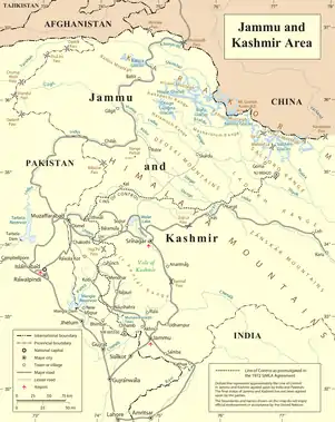
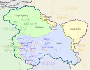
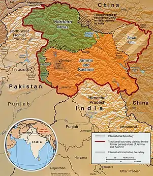
Saltoro valley is Pakistan's highest valley. It is part of Baltistan,[1] and is held by Pakistan. Along with Saltoro Kangri peak and the Saltoro River, it is near the Saltoro Mountain Range. It lies near world's highest battleground Siachen, a territory disputed by India and Pakistan.[2][3] The Actual Ground Position Line (AGPL) between India held and Pakistan held area runs through this range where higher peaks and passes of disputed Siachen area are held by India and Pakistan occupies the lower peaks and valleys.[4] In 1984, India captured most of the disputed Siachen area in the Operation Meghdoot. In April 1986, Pakistan launched an assault in the area, gaining control of a high point in the area located south of Bilafond La, and established a military post on the peak which was named "Quaid Post" in honour of their leader Quaid-e-Azam Muhammad Ali Jinnah.[2][3] Between 23–26 June 1987, India launched a counter Operation Rajiv and snatched the Quaid Post from Pakistan, renaming it Bana Top in the honor of Bana Singh who was awarded India's highest gallantry award Param Vir Chakra.[5][3][2]
See also
- Near the AGPL (Actual Ground Position Line)
- NJ9842 (peak) LoC ends and AGPL begins here
- Gharkun (peak)
- Gyong Kangri (peak)
- Gyong La (pass)
- Goma (Siachen)
- Gyari (valley)
- Chumik Kangri (peak)a
- K12 (mountain) (peak)
- Bana Top (peak)
- Bilafond La
- Saltoro Valley
- Ghent Kangri
- Sia La
- Sia Kangri
- Indira Col
- Borders
- Actual Ground Position Line (AGPL)
- India–Pakistan International Border {IB)
- Line of Control {LoC)
- Line of Actual Control (LAC)
- Sir Creek (SC)
- Borders of China
- Borders of India
- Borders of Pakistan
- Conflicts
- Kashmir conflict
- Siachen conflict
- Sino-Indian conflict
- List of disputed territories of China
- List of disputed territories of India
- List of disputed territories of Pakistan
- Northern Areas
- Trans-Karakoram Tract
- Operations
- Operation Meghdoot, by India
- Operation Rajiv, by India
- Operation Safed Sagar, by India
- Other related topics
- Awards and decorations of the Indian Armed Forces
- Bana Singh, after whom Quaid Post was renamed to Bana Top
- Dafdar, westernmost town in Trans-Karakoram Tract
- India-China Border Roads
- Sino-Pakistan Agreement for transfer of Trans-Karakoram Tract to China
References
- Kunal Verma (2012). "XIV Op Rajiv". The Long Road to Siachen. Rupa. pp. 415–421. ISBN 978-81-291-2704-4.
- Ajai Shukla (30 May 2011). "Army watches as Siachen dialogue resumes". Business Standard.
- How India realised it was at risk of losing the Siachen glacier to Pakistan, The Print, 12 April 2018.
- "Naib Subedar Bana Singh". Bharat Rakshak. Archived from the original on 5 March 2015. Retrieved 27 June 2014.
