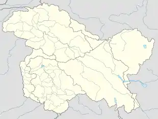
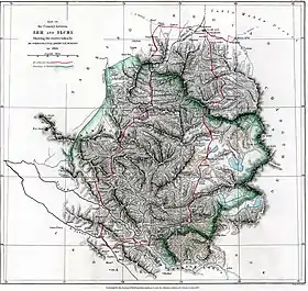
Trans-Karakoram Tract
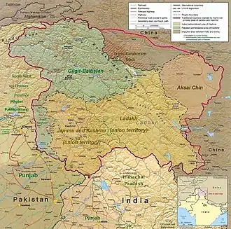
The Trans-Karakoram Tract (Chinese: 喀喇昆仑走廊; pinyin: Kālǎkūnlún zǒuláng, Urdu: شکسگام, romanized: Shaksgám), also known as Shaksgam or the Shaksgam Tract, is an area of more than 5,180 km2 (2,000 sq mi) north of the Karakoram, including the Shaksgam valley and Raskam (Yarkand river valley).[1][2] The tract is administered by the People's Republic of China as part of its Taxkorgan and Yecheng counties in the Xinjiang Uyghur Autonomous Region. Although the area was not part of Kashmir or under Pakistan's control since 1947, it was claimed by Pakistan as part of Kashmir until the 1963 Sino-Pakistan Agreement.[3][4] It is claimed by India[5][6] as part of the union territory of Ladakh.
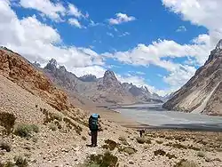
Most of the tract is composed of the Shaksgam Valley and was formerly administered as part of Shigar, a district (formerly a tehsil) in the Baltistan region. A polo ground in Shaksgam was built by the Amacha Royal family of Shigar, and the Rajas of Shigar used to invite the Amirs of Hotan to play polo there. Most of the names of the mountains, lakes, rivers and passes are in Balti/Ladakhi, suggesting that this land had been part of Baltistan/Ladakh region for a long time.
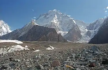
The tract is one of the most inhospitable areas of the world, with some of the highest mountains. Bounded by the Kun Lun Mountains in the north, and the Karakoram peaks to the south, including Broad Peak, K2 and Gasherbrum, on the southeast it is adjacent to the highest battlefield in the world on the Siachen Glacier region which is controlled by India.
History
Historically the people of Hunza cultivated and grazed areas to the north of the Karakoram, and the Mir of Hunza claimed those areas as part of Hunza's territories. Those areas included the Raskam Valley, north of the Shaksgam Valley.[7]
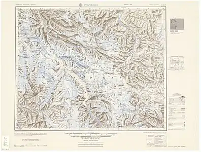
In 1889 the first expedition to the Shaksgam Valley by a European was undertaken by Francis Younghusband (who referred to the Shaksgam as the Oprang).[8]
In March 1899 the British proposed, in a formal Note from Sir Claude MacDonald to China, a new boundary between China and British India. The Note proposed that China should relinquish its claims to suzerainty over Hunza, and in return Hunza should relinquish its claims to most of the Taghdumbash and Raskam districts.[9] The Note proposed a border which broadly followed the main Karakoram crest dividing the watersheds of the Indus River and the Tarim River, but with a variation to pass through a Hunza post at Darwaza near the Shimshal Pass.[9] The Chinese did not respond to the Note and the Indian government never revisited the boundary in the same form again.[10] The MacDonald line was modified in 1905 to include in India a small area east of the Shimshal Pass, to put the border on a stretch of the Shaksgam River.[11]
At the same time, in view of "The Great Game", Britain was concerned at the danger of Russian expansion as Qing dynasty China weakened and so adopted a policy of claiming a border north of the Shaksgam River. This followed a line proposed by Sir John Ardagh in a Memorandum of 1897.[12] That border included the Mir of Hunza's claim over the Raskam Valley. However, British administration never extended north of the Karakoram watershed.[13]
From 1899 until the independence of India and creation of Pakistan in 1947, the representation of the border on maps varied. In 1926 Kenneth Mason explored and surveyed the Shaksgam Valley.[14] In 1927 the Government of British India abandoned any claim to the area north of the MacDonald line, but the decision did not find its way on to British maps.[15] By 1959, however, Chinese maps were published showing large areas west and south of the MacDonald line in China. That year, the Government of Pakistan announced its willingness to consult on the boundary question.[16]
Since 1947, India claims sovereignty over the entire area of the pre-1947 independent state of Jammu and Kashmir and maintains that Pakistan and China do not share a common border.
Sino-Pakistan Frontier Agreement
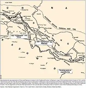
The Government of Pakistan had published an official map depicting the alignment of the northern Border of Kashmir in 1962 which depicted much of the Cis-Kuen Lun Tract (the region between the Karakoram and Kuen Lun mountains) as part of Kashmir and the alignment published by the Government of Pakistan predominantly was similar to and coincided with the portrayal of the northern Border of Kashmir in 1954 by the Times Atlas which had predominantly depicted the Cis-Kuen Lun Tract as a part of Kashmir under the caption "Undefined Frontier area" though at places, the official position of the Government of Pakistan deviated from the position of the Times Atlas, and the Government of Pakistan even depicted areas as part of Kashmir which were to the north of the border of Kashmir as published in 1954 by the Times Atlas. The northern border published by the Times Atlas in 1954 more or less followed the principle of watershed of the Kuen Lun range from the Taghdumbash Pamir to the Yangi Dawan pass north of Kulanaldi but east of the Yangi Dawan Pass, the border deviated from the principle of the watershed of the Kuen Lun range on the edge of the highlands of Kashmir and skipped from the Kuen Lun watershed rather than continuing on the Kilian, Sanju-la and Hindutash border passes despite the statement that “The eastern (Kuenlun) range forms the southern boundary of Khotan”, in the Gazetteer of Kashmir and Ladakh and is crossed by two other passes. The Gazetteer of Kashmír and Ladák compiled under the direction of the Quarter Master General in India in the Intelligence Branch and first Published in 1890 gives a description and details of places inside Kashmir and thus includes a description of the Híñdutásh Pass in north eastern Kashmir in the Aksai Chin area in Kashmir . The aforesaid Gazetteer states in pages 520 and 364 that “The eastern (Kuenlun) range forms the southern boundary of Khotan”, “and is crossed by two passes, the Yangi or Elchi Diwan, .... and the Hindutak (i.e. Híñdutásh ) Díwán”. It describes Khotan as “ A province of the Chinese Empire lying to the north of the Eastern Kuenlun range, which here forms the boundary of Ladák[17]”. Thus the official position of the Government of Pakistan prior to the 1963 Sino-Pakistan Agreement was that the northern border of Pakistan was on the Kuen Lun range and the territory ceded by the Government of Pakistan was not just restricted to the Shaksgam Valley but extended to the Kuen Lun range. For an idea of the extent of the Trans-Karakoram Tract or the Cis-Kuen Lun Tract, a view the map (C) from the Joe Schwartzberg's Historical Atlas of South Asia at DSAL in Chicago with the caption, "The boundary of Kashmir with China as portrayed and proposed by Britain prior to 1947" would show that the geographical and territorial extent of the Trans-Karakoram Tract or the Cis-Kuen Lun Tract is more or less the territory enclosed between the northernmost line and the innermost lines.
In 1959 the Pakistani government became concerned over Chinese maps that showed areas the Pakistanis considered their own as part of China. In 1961 Ayub Khan sent a formal note to China; there was no reply. It is thought that the Chinese might not have been motivated to negotiate with Pakistan because of Pakistan's relations with India. The agreement resulted in the surrendering of 34,000 square kilometres (13,000 square miles) of territory. In the opinion of Jawaharlal Nehru, "According to the survey of Pakistan maps, even those published in 1962, about 11,000 square miles [28,000 km2] of Sinkiang territory formed part of Kashmir. If one goes by these maps, Pakistan has obviously surrendered over 13,000 square miles [34,000 km2] of territory".[18]
After Pakistan voted to grant China a seat in the United Nations, the Chinese withdrew the disputed maps in January 1962, agreeing to enter border talks in March. Negotiations between the nations officially began on October 13, 1962 and resulted in the Sino-Pakistan Agreement signed on 2 March 1963 by foreign ministers Chen Yi of China and Zulfikar Ali Bhutto of Pakistan.[4]
See also
- AGPL (Actual Ground Position Line), south to north runs through the following
- NJ9842, LoC ends and AGPL begins
- Gyong La
- Chumik Glacier
- Saltoro Mountains
- Saltoro Kangri
- Ghent Kangri
- Bilafond La
- Sia La
- Indira Col, AGPL ends at LAC
- Borders
- Actual Ground Position Line (AGPL)
- India–Pakistan International Border {IB)
- Line of Control {LoC)
- Line of Actual Control (LAC)
- Sir Creek (SC)
- Borders of China
- Borders of India
- Borders of Pakistan
- Conflicts
- Kashmir conflict
- Siachen conflict
- Sino-Indian conflict
- List of disputed territories of China
- List of disputed territories of India
- List of disputed territories of Pakistan
- Northern Areas
- Operations
- Operation Meghdoot, by India
- Operation Rajiv, by India
- Operation Safed Sagar, by India
- Other related topics
- Awards and decorations of the Indian Armed Forces
- Bana Singh, after whom Quaid Post was renamed to Bana Top
- Dafdar, westernmost town in Trans-Karakoram Tract
- India-China Border Roads
- List of extreme points of India
- Sino-Pakistan Agreement for transfer of Trans-Karakoram Tract to China
Notes
- Siachen Glacier is under Indian administration despite being labelled "contested territory" in the map.
References
- Snedden, Understanding Kashmir and Kashmiris 2015, p. 238.
- Schofield, Kashmir in Conflict 2003, p. 101.
- Noorani, A. G. (20 October 2006). "Facing the truth". Frontline.
The Shaksgam Valley was never part of Kashmir and the northern and eastern boundaries of Kashmir were undefined
- "Signing with the Red Chinese". Time (magazine). 15 March 1963. Archived from the original on 6 August 2020. Retrieved 28 October 2019.
- R Chandrashekhar (2017). THE GILGIT AND BALTISTAN REGIONS OF JAMMU AND KASHMIR STATE (PDF). Center for Joint Warfare Studies. New Delhi: Xtreme Office Aids Pvt. Ltd. p. 63. ISBN 978-93-84492-36-6.
An area that is legally part of the state of Jammu and Kashmir has since 1963 been administered by China as a part of Kargilik County and Taxkorgan Tajik Autonomous County in the Kashgar Prefecture of Xinjiang Autonomous Region. Prior to 1963 The Shaksgam tract had been administered as a part of Shigar.
- Complete Atlas Of The World (3 ed.). Penguin Random House. 2016. p. 238 – via Internet Archive.
(claimed by India)
- Lall, J. S. (1989), Aksaichin and Sino-Indian Conflict, Allied Publishers, p. 85
- Younghusband, Francis (1896). The Heart of a Continent. pp. 200ff. ISBN 9788120608504.
- Woodman, Himalayan Frontiers (1970), pp. 102, 366.
- Woodman, Himalayan Frontiers (1970), pp. 74–75, 102.
- Woodman, Himalayan Frontiers (1970), p. 308.
- Woodman, Himalayan Frontiers (1970), p. 107.
- Woodman, Himalayan Frontiers (1970), p. 298, citing Alistair Lamb in the Australian Outlook, December 1964
- Mason, Kenneth (1928). Exploration of the Shaksgam Valley and Aghil ranges, 1926. pp. 72ff. ISBN 9788120617940.
- Woodman, Himalayan Frontiers (1970), pp. 107, 298.
- The Geographer. Office of the Geographer. Bureau of Intelligence and Research. Department of State, United States of America (November 15, 1968), China – Pakistan Boundary (PDF), International Boundary Study, 85, Florida State University College of Law
- The Gazetteer of Kashmír and Ladák compiled under the direction of the Quarter Master General in India in the Intelligence Branch and first Published in 1890, at page 493
- Formal statement of Mr. Jawaharlal Nehru in the Parliament of India on March 5, 1963
Bibliography
- Schofield, Victoria (2003) [First published in 2000], Kashmir in Conflict, London and New York: I. B. Taurus & Co, ISBN 1860648983
- Snedden, Christopher (2015), Understanding Kashmir and Kashmiris, Oxford University Press, ISBN 978-1-84904-342-7
- Woodman, Dorothy (1969), Himalayan Frontiers, Barrie & Rockcliff
- Woodman, Dorothy (1970), Himalayan Frontiers: A Political Review of British, Chinese, Indian, and Russian Rivalries, Praeger