Stoughton, Saskatchewan
Stoughton is a town in Saskatchewan, Canada. In 2011 it had a population of 694. Stoughton was originally called New Hope. The tiny settlement of New Hope was barely three years old when the C.P.R. arrived in this part of the province in 1904. When the railway chose a location a little to the south for its depot calling it Stoughton, New Hope was soon moved to join it.
Stoughton | |
|---|---|
Town | |
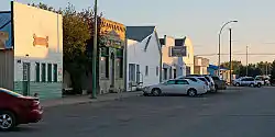 Main Street | |
 Stoughton Location of Stoughton in Saskatchewan  Stoughton Stoughton (Canada) | |
| Coordinates: 49.675°N 103.037°W | |
| Country | Canada |
| Province | Saskatchewan |
| Region | Saskatchewan |
| Census division | 1 |
| Rural Municipality | Tecumseh |
| Post office Founded | 1901 |
| Government | |
| • Mayor | Bill Knous |
| • Town Manager | Chris Miskolczi |
| • Governing body | Stoughton Town Council |
| Area | |
| • Land | 3.41 km2 (1.32 sq mi) |
| Population (2011) | |
| • Total | 694 |
| • Density | 203.2/km2 (526/sq mi) |
| Time zone | CST |
| Postal code | S0G 4T0 |
| Area code(s) | 306 |
| Highways | Highway 13 Highway 33 Highway 47 |
| Website | http://stoughtonsk.ca |
| [1][2] | |
A small police service, the Stoughton Police Service no longer exists and is now in partnership with the Royal Canadian Mounted Police to provide policing service to the town and surrounding area. This town is approximately eighty-eight miles southeast of Regina. It is the administrative headquarters of the Ocean Man First Nations band government.[3] They contain three nations which are Assiniboine, Saulteaux and Cree.
The town is served by Highway 13, Highway 33 and Highway 47.
Demographics
| Canada census – Stoughton, Saskatchewan community profile | |||
|---|---|---|---|
| 2011 | 2006 | ||
| Population: | 694 (6.3% from 2006) | 653 (-9.3% from 2001) | |
| Land area: | 3.41 km2 (1.32 sq mi) | 2.13 km2 (0.82 sq mi) | |
| Population density: | 203.2/km2 (526/sq mi) | 306/km2 (790/sq mi) | |
| Median age: | 43.4 (M: 42.4, F: 44.4) | 46.8 (M: 44.7, F: 49.8) | |
| Total private dwellings: | 325 | 325 | |
| Median household income: | |||
| References: 2011[4] 2006[5] earlier[6] | |||
Gallery
 road and grain elevator
 grain elevator
 rest stop
References
- National Archives, Archivia Net. "Post Offices and Postmasters". Retrieved 2014-05-26.
- Government of Saskatchewan, MRD Home. "Municipal Directory System". Retrieved 2014-05-26.
- http://www.sicc.sk.ca/archive/bands/bocean.html
- "2011 Community Profiles". 2011 Canadian Census. Statistics Canada. July 5, 2013. Retrieved 2012-06-24.
- "2006 Community Profiles". 2006 Canadian Census. Statistics Canada. March 30, 2011. Retrieved 2012-06-24.
- "2001 Community Profiles". 2001 Canadian Census. Statistics Canada. February 17, 2012.
| Wikimedia Commons has media related to Stoughton, Saskatchewan. |
| Cities | 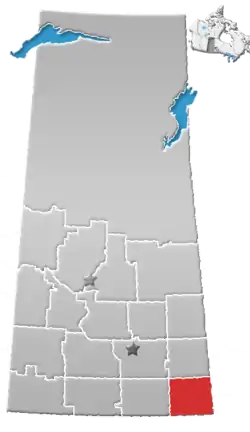 | ||||
|---|---|---|---|---|---|
| Towns | |||||
| Villages | |||||
| Rural municipalities | |||||
| First Nations | |||||
| Indian reserves | |||||
| Unincorporated communities |
| ||||