Caraquet Parish, New Brunswick
Caraquet is a civil parish in Gloucester County, New Brunswick, Canada.[2]
Caraquet | |
|---|---|
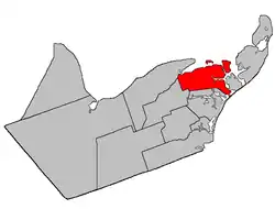 Location within Gloucester County, New Brunswick | |
| Coordinates: 47.7275°N 64.875°W | |
| Country | |
| Province | |
| County | Gloucester |
| Erected | 1831 |
| Area | |
| • Land | 109.97 km2 (42.46 sq mi) |
| Population (2016)[1] | |
| • Total | 1,337 |
| • Density | 12.2/km2 (32/sq mi) |
| • Change 2011-2016 | |
| • Dwellings | 668 |
| Time zone | UTC-4 (AST) |
| • Summer (DST) | UTC-3 (ADT) |
All municipalities and LSDs are members of the Acadian Peninsula Regional Service Commission (APRSC).[3]
Origin of name
Ganong described the origin of the name as uncertain, the Mi'kmaq Caluget possibly being their prounciation of a French name for the area.[4]
History
Caraquet was erected in 1831 from Saumarez Parish;[5] it originally included Shippegan Parish and Paquetville Parish.
In 1851 Shippegan was erected as its own parish.[6]
In 1897 Paquetville was erected as its own parish.[7]
Delineation
Caraquet Parish is defined in the Territorial Division Act[2] as being bounded:
- North by Caraquet Bay and Caraquet Harbour; southeast by the Gulf of Saint Lawrence; east by a line running from the west side or entrance of Little Pokemouche Lagoon[lower-alpha 1] north fifty-two degrees west until it strikes the south branch of Saint Simons Inlet,[lower-alpha 2] and thence from the centre of the said inlet and the north entrance of Grant Shippegan Harbour[lower-alpha 3] to the Chaleur Bay; southwest and south by the northeast line of lot no. 1 (William Ferguson) and the prolongation thereof north thirty-six degrees west three hundred chains; thence in a direct line westerly to the northwest angle of lot no. 255, granted to P. de La Vivitiere, on the west side Maltempec Road;[lower-alpha 4] west by Paquetville Parish, including the islands of Caraquet and Pokesudie.
Governance
The northern mainland of the parish is divided between three municipalities; from east to west, these are the village of Bas-Caraquet, the town of Caraquet, and the eastern part of the village of Bertrand. The remainder of the parish consists of four LSDs and part of a fifth. These LSDs are:
- Blanchard Settlement (August 4, 1987)[8] assesses for the additional services of street lighting and community services, both added in 1988. Consists of the community of Village-Blanchard (formerly Blanchard Settlement) and grants along the Waugh and Godin Roads.
- Inkerman Centre (extended into parish on April 21, 1987)[9] assesses for the additional service of street lighting. The portion in this parish consists of the grants south of the wetlands along Ruisseau à Jules and all of the parish south of those grants.
- Pokesudie (March 22, 1988)[10] assesses for the additional services of street lighting (added 1988) and community services. Consists of Pokesudie Island and Little Pokesudie Island. The community of Pokesudie is on the main island.
- St. Simon (September 22, 1971)[11] assesses for the additional services of street lighting and recreational facilities. Consists of grants east of the former CNR line and north of the wetlands along Ruisseau à Isaac. Includes the communities of Centre-Saint-Simon and Haut-Saint-Simon.
- The parish of Caraquet (established 1968).[12] Originally including all the unincorporated parts of the parish, it has been reduced to four mainland areas and two islands.
- Grants in the southwestern corner of the parish, along Thériault, Lavigne, and Haché Roads, containing more than five thousand acres.
- Wetlands along Ruisseau à Isaac and Ruisseau à Jules.
- Ten grants between the mouth of the Saint-Simon River and the southwestern corner of Bas-Caraquet, containing about nine hundred acres.
- A small area on the southern bank of the Saint-Simon River where the Caraquet boundary cuts through a peninsula, containing less than five acres.
- Munro Island
- Caraquet Island
Communities
Parish population total does not include incorporated municipalities (in bold):
|
|
Demographics
Population
| Canada census – Caraquet Parish, New Brunswick community profile | |||
|---|---|---|---|
| 2016 | 2011 | 2006 | |
| Population: | 1,337 (-3.3% from 2011) | 1,382 (-8.5% from 2006) | 1,511 (-4.9% from 2001) |
| Land area: | 109.97 km2 (42.46 sq mi) | 109.20 km2 (42.16 sq mi) | 109.20 km2 (42.16 sq mi) |
| Population density: | 12.2/km2 (32/sq mi) | 12.7/km2 (33/sq mi) | 13.8/km2 (36/sq mi) |
| Median age: | 51.8 (M: 52.3, F: 51.1) | 48.3 (M: 48.6, F: 48.1) | 44.2 (M: 44.4, F: 43.9) |
| Total private dwellings: | 668 | 618 | 644 |
| Median household income: | $52,224 | $.N/A | $39,145 |
| Notes: 2011 income data for this area has been suppressed for data quality or confidentiality reasons. – References: 2016[13] 2011[14] 2006[15] earlier[16] | |||
|
|
| |||||||||||||||||||||||||||
| [17][18][1] | |||||||||||||||||||||||||||||
Language
| Canada Census Mother Tongue - Caraquet Parish, New Brunswick[17] | ||||||||||||||||||
|---|---|---|---|---|---|---|---|---|---|---|---|---|---|---|---|---|---|---|
| Census | Total | French |
English |
French & English |
Other | |||||||||||||
| Year | Responses | Count | Trend | Pop % | Count | Trend | Pop % | Count | Trend | Pop % | Count | Trend | Pop % | |||||
2011 |
1,365 |
1,340 | 98.17% | 25 | 1.83% | 0 | 0.00% | 0 | 0.00% | |||||||||
2006 |
1,500 |
1,450 | 96.67% | 40 | 2.67% | 0 | 0.00% | 10 | 0.66% | |||||||||
2001 |
1,575 |
1,565 | 99.36% | 10 | 0.64% | 0 | 0.00% | 0 | 0.00% | |||||||||
1996 |
1,720 |
1,675 | n/a | 97.38% | 35 | n/a | 2.04% | 10 | n/a | 0.58% | 0 | n/a | 0.00% | |||||
See also
Notes
- Baie de Petit-Pokemouche
- Baie Saint-Simon-Sud
- Baie de Shippegan. Originally the text read Grand Shippegan Harbour; the error occurred in the 1973 edition of the Revised Statutes of New Brunswick.
- Lavigne Road
References
- "Census Profile, 2016 Census Caraquet, Parish [Census subdivision], New Brunswick". Statistics Canada. Retrieved September 10, 2019.
- "Chapter T-3 Territorial Division Act". Government of New Brunswick. Retrieved 13 November 2020.
- "Communities in each of the 12 Regional Service Commissions (RSC) / Les communautés dans chacune des 12 Commissions de services régionaux (CSR)" (PDF), Government of New Brunswick, July 2017, retrieved 2 February 2021
- Ganong, William F. (1896). A Monograph of the Place-Nomenclature of the Province of New Brunswick. Royal Society of Canada. p. 225.
- "1 Wm. IV c. 19 An Act to erect Two new Parishes in the County of Gloucester.". Acts of the General Assembly of His Majesty's Province of New-Brunswick, Passed in the Year 1831. Fredericton: Government of New Brunswick. 1831. pp. 68–69.
- "14 Vic. Local Acts c. 1 An Act for erecting the Parish of Caraquet, in the County of Gloucester, into two separate Parishes.". Acts of the General Assembly of Her Majesty's Province of New Brunswick, Passed in the Year 1851. Fredericton: Government of New Brunswick. 1851. p. 1. Local Acts have own page numbering and follow page 56.
- "60 Vic. c. 49 An Act to divide the Parish of Caraquet, in the County of Gloucester, into two Separate Parishes.". Acts of the General Assembly of Her Majesty's Province of New Brunswick. Passed in the Month of March, 1897. Fredericton: Government of New Brunswick. 1897. pp. 362–365.
- Regulation 87-104 under the Municipalities Act.
- Regulation 87-42 under the Municipalities Act.
- Regulation 88-42 under the Municipalities Act.
- "Regulation 71–97 under the Municipalities Act (O. C. 71–678)". The Royal Gazette. Fredericton. 129: 678. 29 September 1971.
- "Regulation 68–64 under the Municipalities Act (O. C. 68–592)". The Royal Gazette. Fredericton. 126: 407–408. 24 July 1968.
- "2016 Community Profiles". 2016 Canadian Census. Statistics Canada. February 21, 2017. Retrieved 2019-09-10.
- "2011 Community Profiles". 2011 Canadian Census. Statistics Canada. July 5, 2013. Retrieved 2014-04-02.
- "2006 Community Profiles". 2006 Canadian Census. Statistics Canada. March 30, 2011. Retrieved 2014-04-02.
- "2001 Community Profiles". 2001 Canadian Census. Statistics Canada. February 17, 2012.
- Statistics Canada: 1996, 2001, 2006, 2011 census
- Caraquet, New Brunswick (Code 1315026) and Gloucester, New Brunswick (Code 1315) (table) 2011 Census of Population. (Statistics Canada).
External links
Places adjacent to Caraquet Parish, New Brunswick | ||||||||||
|---|---|---|---|---|---|---|---|---|---|---|
| ||||||||||
| Subdivisions | |
|---|---|
| Cities | |
| Counties | |
| |