Shippegan Parish, New Brunswick
Shippegan (incorrectly Shippagan from the French colloquial spelling) is a civil parish in Gloucester County, New Brunswick, Canada.[2]
Shippegan
Shippagan | |
|---|---|
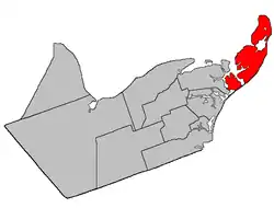 Location within Gloucester County, New Brunswick | |
| Coordinates: 47.855°N 64.62°W | |
| Country | |
| Province | |
| County | Gloucester |
| Erected | 1851 |
| Area | |
| • Land | 208.08 km2 (80.34 sq mi) |
| Population (2016)[1] | |
| • Total | 4,800 |
| • Density | 23.1/km2 (60/sq mi) |
| • Pop 2011-2016 | |
| • Dwellings | 2,689 |
| Time zone | UTC-4 (AST) |
| • Summer (DST) | UTC-3 (ADT) |
For governance purposes it is the most subdivided parish in the province, with two towns: Shippagan and Lamèque; two villages: Le Goulet and Sainte-Marie-Saint-Raphaël; and fourteen local service districts: Baie du Petit Pokemouche, Cap-Bateau, Chiasson-Savoy, Coteau Road, Haut-Lamèque, Haut-Shippagan, Miscou Island, Petite-Lamèque, Pigeon Hill, Pointe-Alexandre, Pointe-Canot, Pointe-Sauvage (Indian Point) and Ste. Cecile and the parish of Shippegan (which further includes the special service area of Pointe Brûlée), all of which are members of the Acadian Peninsula Regional Service Commission (APRSC).[3]
The parish consists of the two main islands of Miscou and Lamèque[lower-alpha 1]; the former Taylor Island, now joined to the mainland by an isthmus; and several smaller islands and sandbars.
Origin of name
The parish takes its name from Shippegan Island, a name formerly used for Lamèque Island. The island's name comes from the Mi'kmaq name Sepaguncheech, translated by Rand as a passage used by ducks, a name which originally applied only to Shippegan Harbour.[4]
History
Shippegan was erected in 1851 from Caraquet Parish.[5]
Delineation
Shippegan Parish is defined in the Territorial Division Act[2] as being bounded:
- West by Caraquet Parish; northwesterly by Caraquet Bay and Chaleur Bay; and southeasterly by the Gulf of Saint-Lawrence, including the islands of Shippegan[lower-alpha 2] and Miscou.
Communities
Parish population total does not include incorporated municipalities (in bold):
|
|
|
Demographics
Population
|
LanguageMother tongue (2016)[1]
|
See also
Notes
- Originally named Shippegan Island.
- Now called Lamèque Island
References
- "Census Profile, 2016 Census: Shippagan, Parish [Census subdivision], New Brunswick". Statistics Canada. Retrieved August 29, 2019.
- "Chapter T-3 Territorial Division Act". Government of New Brunswick. Retrieved 13 November 2020.
- "Communities in each of the 12 Regional Service Commissions (RSC) / Les communautés dans chacune des 12 Commissions de services régionaux (CSR)" (PDF), Government of New Brunswick, July 2017, retrieved 2 February 2021
- Ganong, William F. (1896). A Monograph of the Place-Nomenclature of the Province of New Brunswick. Royal Society of Canada. pp. 272–273.
- "14 Vic. Local Acts c. 1 An Act for erecting the Parish of Caraquet, in the County of Gloucester, into two separate Parishes.". Acts of the General Assembly of Her Majesty's Province of New Brunswick, Passed in the Year 1851. Fredericton: Government of New Brunswick. 1851. p. 1. Local Acts have own page numbering and follow page 56.
- Statistics Canada: 1996, 2001, 2006 census
- 2011 Statistics Canada Census Profile: Shippagan Parish, New Brunswick
Places adjacent to Shippegan Parish, New Brunswick | ||||||||||
|---|---|---|---|---|---|---|---|---|---|---|
| ||||||||||
| Subdivisions | |
|---|---|
| Cities | |
| Counties | |
| |
