Skardu District
The Skardu District (Urdu: ضلع سکردو) is one of the 14 districts of Pakistan-administered territory of Gilgit-Baltistan.[1] The Skardu District is bounded on the east by the Ghanche District, on the south by the Kharmang District, on the west by the Astore District and on the north-west by the Rondu District. The district headquarters is the town of Skardu, which is also the division headquarters.
Skardu District
ضلع سکردو | |
|---|---|
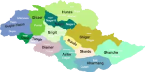 Map of Gilgit–Baltistan showing its 14 districts | |
| Sovereign state | |
| Administered territory | |
| Division | Baltistan Division |
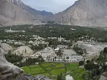
| Headquarters | Skardu |
| Area | |
| • Total | 15,000 km2 (6,000 sq mi) |
| Population | |
| • Total | 214,848 |
| Number of tehsils | 4 |
Mountain peaks and glaciers
The highest peak in the Skardu District is K2 (8,611 m), which is the highest peak in Pakistan and its two dependent territories and is the second-highest peak in the world. The Baltoro Muztagh, the subrange of the Karakoram Mountains that includes the mighty peaks of K2 (8,611 m), Broad Peak (8,047 m), the Gasherbrums (8,000+ m), and Masherbrum (7,821 m), is located in the Skardu District. Askole is the last settlement in the district for all treks to Concordia (the confluence of the Baltoro Glacier and the Godwin-Austen Glacier). The Biafo Glacier and a major part of the Hispar Glacier are also located in the Skardu District.

Education
According to the Alif Ailaan Pakistan District Education Rankings 2015, the Skardu District is ranked 14th out of 148 districts in terms of education. For facilities and infrastructure, the district is ranked 89th out of 148 districts.[2]
Deosai National Park
The Deosai Plateau is one of the highest plateaus in the world. The Skardu District shares the area of the Deosai National Park with the Astore District, which has a major portion. The Deosai Plateau is the second- highest plateau in the world, after the Tibet Plateau.
Major towns
The major towns of the Skardu District are: Hussainabad Skardu, Mehdiabad, Parkutta, Rondu Valley, Satpara, Sermik, and Skardu.
Demography
People of the Skardu District are predominantly of the Shia sect of Islam, where 98% of the people are of the Shia sect, 2% are of the Noorbakshi sect, and 2% are of the Sunni sect.[3]
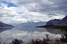
Lakes
The main lakes in the district are:
Mountain passes
The Gondogoro Pass is located in the Skardu District.
See also
Geography of Gilgit–Baltistan
References
- Hussain, Zakir (2018). "Geo-Strategic Significance of Gilgit Baltistan: Political, Economic and Security Interests of Pakistan, India and China (1947-2013)". University of the Punjab, Lahore.
- "Individual district profile link, 2015". Alif Ailaan. Retrieved 2015-05-07.
- "Sectarian Conflict in Gilgit-Baltistan". PILDAT. 1 May 2011.
External links
| Wikimedia Commons has media related to Skardu District. |
Capital: Gilgit | |
| Passes | |
| Valleys | |
| Cities and towns | |
| Rivers, glaciers and lakes | |
| Architecture | |
| See also | |