Ghanche District
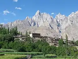
The Ghanche District (Urdu: ضلع گانچھے, Balti: གངས་ཅེ) is the easternmost district of the 14 districts of Pakistan-administered terrirory of Gilgit-Baltistan.[1][2][3] Pakistan Army's brigade headquarters is located at Goma, Ghanche district.[4] Pakistan Army's Gayari Sector Battalion Headquarters is 20 miles west of Siachen Glacier. With its administrative headquarters in the historic city of Khaplu, the Ghanche District is famous as a tourist destination for its outstanding scenery and high altitude landscapes.
Ghanche District
ضلع گانچھے | |
|---|---|
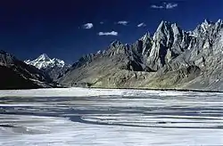
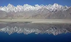
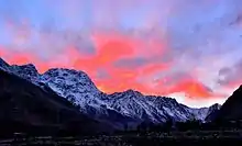
 A view of the serrated peaks that are typical of the high Karakoram Mountains | |
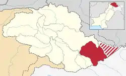 Map of Gilgit–Baltistan with the Ghanche District highlighted in red | |
| Sovereign state | |
| Administered territory | |
| Division | Baltistan Division |
| Headquarters | Khaplu |
| Government | |
| • Deputy Commissioner | Adeel Haider (PAS) |
| Area | |
| • Total | 4,052 km2 (1,564 sq mi) |
| Population (2017) | |
| • Total | 160,000 |
| Number of tehsils | 3 |
Geography
The Ghanche District is bounded on the north-east by the Kashgar Prefecture and the Hotan Prefecture of China's Xinjiang Uyghur Autonomous Region, to the south-east by the Leh District of Indian-administered Ladakh, on the south-west by the Kharmang District, on the west by the Skardu District, and on the north-west by the Shigar District. The Actual Ground Position Line (AGPL) is located at the easternmost part of the Ghanche District, across the Saltoro Ridge. Territory east of the AGPL, including the entire Siachen Glacier, is currently controlled by India. It has been proposed by moderates in both India and Pakistan to turn the entire Siachen Glacier area into a "peace park". The area west of the Saltoro Ridge is controlled by Pakistan.
The headquarters of the Ghanche District is the town of Khaplu.[5] The Ghanche District is the coldest place within Pakistan and its administered territories and is referred to as the "third pole", with temperatures reaching below -20 °C in the winter. The Khaplu Valley and the Hushe Valley form the gateway for the great Baltoro Muztagh, the subrange of the Karakoram Mountains[6] that includes the mighty peaks of K2 (8,611 m), Broad Peak (8,047 m), the Gasherbrums (8,000+ m) and Masherbrum (7,821 m),all of which are also included in the Skardu District).[7]
Etymology
The word "gang" in the Balti language means "glacier", and '"che" is used as a superlative term to indicate "an abundance". The word is used by the residents of the Khaplu Valley in the name of the Ghanche Nallah, a seasonal stream which flows through the town of Khaplu during the summer season. When the Pakistani government elevated the status of the Ghanche Tehsil to that of a district, the people of the valley willingly selected the name "Ghanche".[8]
Administration
.jpg.webp)
The Ghanche District is divided into three tehsils:
- Khaplu Tehsil
- Daghoni Tehsil
- Masherbrum Twehsil
The three tehsils are divided into 56 union councils, with each council containing many villages. Four villages of the Chorbat Valley were lost in the Indian invasion in 1971.[9][10] Those were the villages of Chalunka, Thang, Turtuk, and Tyakshi. .[11] Some of them are given in the chart below.
| Name of Village/Town[12] | Muhallahs in the Village/Town |
|---|---|
| Khaplu Bala | Mouldomar, Sargaib, Stodkhoor (Braqchansar, Khansar, Banpi, Hundili Gharalti, Laxar), Khanqah, Naqzigroung, Gamba Bathong, Goma Bathong, Goma staqji (Muhsinabad), Langkhong (Islamabad), Hatchhe khar, Hatchhe, Hatchhe, Dinis(faizbaksh sector), Gamba Bngriya, goma Bngriya, Doqsa Garbochung, |
| Khaplu Pain | Kraming, Malaliwa, Ansoq, Kongbozang, Gongmayar, Baqerpi gund. Mekxerpi, Goqpi Mirpiser, Thaskong, Ghares, Morgoto, Helam groung, Braqchan, Chaqchan, mongrong, Beadenday, Hipi, Askari gond, Chilabatigond, Kowakhong, Stronpi, Konowa, Khsergroung, Garboung |
| Balghar | Soq,Yompoya,Loda,Khankha Groing, marmung,Gon,Chan Gon, Ungbo,Gongmayar,Bazawa,Khodakha,Garieppa,Kharwathaing,khashou,Gamba Bardas. |
| Kharkoo | Mandik, Arapa, Malayar, Thana Gamba Trangzong, Gongma Trangzong, Garbong, Youlskil, Piyara, Shopacholi, Lahar, Sogha |
| Haldi | |
| Chorbat | Siksa (Kalan, Sokhmos), Chowar, Siari, Piun, Hassanabad, Ameerabad, Dawoo, Marcha, Partook, Thoqmus, Franu |
| Saling | Banpi Gabkhore, Doqbar, Biliggrong, Sotol, Gond |
| Thagas | * Newti Chan, Olday Groung, Garbi Groung, Kharat, Arif Abad, Chansoq,
, Farol, Baqmacho, Kharkhor, Bandy Groung, Arappi Groung, Ool, Tholdi, Dung,Lhangkhani Groung. |
| Yugo | Baqir Colony |
| Ghawari | Ghulu Khor, Manjar, Sain (Hill Town), Chogo Grong, Shahoba, Zangi Ba, Manowa, Sobi Gon, Rahinpi Khor, Mala Abdul pi khor, Mayokhor, Duskhor, Soq, Gintha |
| Kuro | Farool, Khankah grong, Sato, Bani gala ,Gharaqpi gond, Katchurdas,Khuram abad |
| Gulshan-e-Kabir | Tranzong, Gonpon, Kharkhor (Kharkhor & Bongri), Farol (Gapkhor & Yarol) |
| Dumsum | mallon, gabser, mongron,khachepa,yarkhor,oling,skoungoa, barngmalla, |
| Ghursay | Goma(turu,lagaf),Skilma(dankhor,khanfuva,burcon,zgakhon),Gamba(karowa,lunkhavikhor,kazimpikhor,raisha),
Paindo(paindo,ghazithang) |
| Sino | |
| Talis | Nima bazar, hussani chock, |
| Saltoro | Mandik, Saith, Ghaglu and Goma |
| Surmo | Choghogrong, Tarkari, Tishari, Gond, Khar |
| Kundos | Karmanding, Choghogrong, Lachat, Thang, Hano, Khorkondo |
| Machulu | Ashurpi, Malikpi, Manthalpi, Khadi, Badawa, Hilbi, Mallon, Teshari, Marin, Bongri, Baqdurpi |
| Hushe | |
| Marzi Gon | |
| BARA Valley Baltistan | Gumba BARA (Hilfiyuoq, Kharfiyouq, Bara Gond, BrouqPa, Thupori), Gungma BARA (Spinpa, Sampa, MantholPa, Khanka, Pandiva, Darussalam, Mirikpa, Shourova, MominPa, QadeerPa, Tatous) |
| Thalay | Haltagari Baltoro, daltir, yarkhor, taso, harangus, parangus, Chundu, khasomik, bordas, gaworic, lodas. |
| Keris | Oroba, Sumalsa, kashiba, Sadat colony, Barchong, Khargrong, Dangah, Youljuk, Charathang, Ural Gone, Banpa,Mustafaabad,Shagaran,barchong. |
Religion
The majority of the people living in the Ghanche District are Buddhist(51.7%).Among Muslims,70% belongs to Noorbakhshi sect, with the rest belonging to the Shia, Sunni, and Wahabi sects. A religious leader locally called a "bowa" has a very important place in Ghanche society.
Education
According to the Alif Ailaan Pakistan District Education Rankings 2017, Ghanche is ranked 29th out of 141 districts in terms of education. For facilities and infrastructure, the district is ranked 118th out of 155.[13]
See also
References
- "The serenity of Ghanche: Of mountains, rivers and valleys".
- "Mapping education india2015".
- "Rifts within Nurbakhshiyas: Dozens arrested after clashes in Ghanche Valley".
- "The real enemy on the world's highest battlefield".
- "Khaplu — off the beaten path".
- Balghari, Sajjad H:"Sayyid Muhammad Nurbakhsh Qahistani", Monthly Nawa-i-Sufia, Islamabad, Issoue No.12, 1995
- "History of Ganche and places to see". Archived from the original on 2013-06-18.
- Arz-e-Shimal by Alhaj Muhammad Ibrahim Zair
- "Turtuk, a Promised Land Between Two Hostile Neighbours".
- "An encounter with the 'king' of Turtuk, a border village near Gilgit-Baltistan".
- "geography of baltistan".
- District Body Ghanche
- "Pakistan District Education Rankings 2017" (PDF). Alif Ailaan. Retrieved 2019-08-16.
Capital: Gilgit | |
| Passes | |
| Valleys | |
| Cities and towns | |
| Rivers, glaciers and lakes | |
| Architecture | |
| See also | |