Astore District
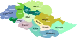
Astore District (Urdu: ضلع استور) is one of the 14 districts of the Pakistani-administered territory of Gilgit−Baltistan.[1] Its administrative headquarters are located at Eidgah in the Astore Valley. The Astore District is bounded by Gilgit District to the north, Roundu District to the northeast, Skardu District to the east, Kharmang District to the southeast, Diamer District to the west, the Neelum District of Azad Jammu and Kashmir to the southwest, and the Bandipore District of Indian-administered Jammu and Kashmir to the south.
Astore District
ضلع استور | |
|---|---|
 Nanga Parbat seen from the Rama Valley near Astore District in August 2016 | |
  | |
| Country | |
| Adm. Unit | |
| Division | Diamer Division |
| Headquarters | Eidgah |
| Area | |
| • Total | 5,092 km2 (1,966 sq mi) |
| Population (1998) | |
| • Total | 71,666 |
| Number of tehsils | 2 |
Astore Valley

The Astore Valley has an area of 5,092 km² and is at an altitude of 2,600 metres (8,500 ft). The valley has approximately 250 square kilometres (97 sq mi) of glacier cover.[2] The nearest glacier after entering the valley is the Harcho Glacier,[3]and the most accessible glacier is the Siachen Glacier.[4]
Accessibility
Eidgah is connected to Gilgit, which is well connected by air with Islamabad and by road with Islamabad / Rawalpindi, Chitral, and Skardu. There are two ways of access to Eidgah. The first is from Skardu via the Deosai Plateau 143 kilometres (89 mi),[5] but that route cannot be used from November to June due to heavy snowfall. The second way, year round, is from Gilgit via Jaglot 128 kilometres (80 mi).[6]
History
Around 1600, according to the Imperial Gazetteer of India:
Ghāzī Mukhpun, a Persian adventurer, is said to have married a princess of the Skārdu reigning family. The four sons born of this union became Rās of Astor, Kharmang, Rondu, and Skārdu, respectively, and from them are descended the families of the present chiefs of those places. The independence of Astor ceased with the Dogra conquest.[7]
Climate
The Astore Valley has a moderate climate during the summer. In the winter it can snow up to 2-3 feet (60-90;cm) in the main valleys and up to 4-5;feet (100;150;cm) in the mountains. In the Mirmalik Valley, it can snow up to 6 feet (1.8 m) in February.
Languages
The main language spoken in the valley is Shina. Urdu, which is the national language of Pakistan, is the second most frequently spoken language. There are different dialects of Shina spoken in the region. Since the Astore Valley has a history of modest tourist traffic during the summer, local guides and police in Eidgah and Tarashing may speak some English.
Education
According to the Alif Ailaan Pakistan District Education Rankings 2015, the Astore District is ranked 32nd out of 148 districts in terms of education. For facilities and infrastructure, the district is ranked 114th out of 148, and the first lady governor of Gilgit-Baltistan, Dr. Shama Khalid, was from the Astore District.[8]
Transportation
In the past, due to rough modes of transportation, there were some negative perceptions about travel in the Astore Valley, but nowadays there are paved roads connecting Islamabad and Gilgit by way of the Karakoram Highway. However, landslides and rockfall may still be issues in some areas of the Indus Valley. There is a permanent road to Gilgit, as well as seasonal road access to Skardu via the Deosai Plateau. It's now possible to obtain several types of vehicles (jeeps, SUVs, taxis, and wagons) and to hire jeeps and SUVs at affordable prices. The most used vehicles are jeeps and SUVs, with a local preference for Pajeros and Landcruisers.
References
- "GB notifies four more districts, total number of districts now 14". pakistantoday.com.
- Sher Muhammad, Lide Tian, Asif Khan, Early twenty-first century glacier mass losses in the Indus Basin constrained by density assumptions, Journal of Hydrology, Volume 574, 2019, Pages 467-475
- MUHAMMAD, S., TIAN, L., & NÜSSER, M. (2019). No significant mass loss in the glaciers of Astore Basin (North-Western Himalaya), between 1999 and 2016. Journal of Glaciology, 65(250), 270-278. doi:10.1017/jog.2019.5
- Muhammad, S. and Tian, L. (2016) ‘Changes in the ablation zones of glaciers in the western Himalaya and the Karakoram between 1972 and 2015’, Remote Sensing of Environment. Elsevier Inc., 187, pp. 505–512. doi: 10.1016/j.rse.2016.10.034.
- "Distance from Skardu via Deosai Plains". Google Maps. Retrieved 4 August 2019.
- "Distance from Gilgit via Jaglot". Google Maps. Retrieved 4 August 2019.
- Gilgit - Imperial Gazetteer of India, v. 12, p. 239 According to the Imperial Gazetteer, which was compiled in the first decade of the twentieth century, the marriage took place over three hundred years previously.
- "Individual district profile link, 2015". Alif Ailaan. Archived from the original on 26 March 2016. Retrieved 7 May 2015.
| Wikimedia Commons has media related to Astore District. |
Capital: Gilgit | |
| Passes | |
| Valleys | |
| Cities and towns | |
| Rivers, glaciers and lakes | |
| Architecture | |
| See also | |