Stanley Parish, New Brunswick
Stanley is a civil parish in York County, New Brunswick, Canada.[2]
Stanley | |
|---|---|
 | |
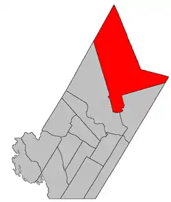 Location within York County, New Brunswick. | |
| Coordinates: 46.4975°N 66.71°W | |
| Country | |
| Province | |
| County | York |
| Erected | 1837 |
| Dissolved | 1838 |
| Reërected | 1847 |
| Area | |
| • Land | 1,222.02 km2 (471.82 sq mi) |
| Population (2016)[1] | |
| • Total | 832 |
| • Density | 0.7/km2 (2/sq mi) |
| • Pop 2011-2016 | |
| • Dwellings | 413 |
| Time zone | UTC-4 (AST) |
| • Summer (DST) | UTC-3 (ADT) |
For governance purposes it is divided between the village of Stanley, the incorporated rural community of Upper Miramichi,[3] and the local service district of the parish of Stanley.[4] Upper Miramichi is a member of the Greater Miramichi Regional Service Commission (GMRSC),[5] the others of Regional Service Commission 11 (RSC11).[5]
Origin of name
The parish takes its name from settlement of Stanley, in turn named for Lord Stanley,[6] Secretary of State for War and the Colonies at the time and an early supporter of the New Brunswick and Nova Scotia Land Company.
History
The first iteration of Stanley was erected in 1837 from Douglas and Saint Marys Parishes.[7] The Taxis River formed the northern boundary.
In 1838 Stanley was dissolved.[8]
In 1847 the modern Stanley was erected from Douglas and Saint Marys,[9] expanding to include the northern part of the county.
Delineation
Stanley Parish is defined in the Territorial Division Act[2] as being bounded:
- All that part of the County bounded southerly and westerly by a line running east from the northwest angle of the grant to D. Campbell and others, and a line running from said angle southerly along the various courses of the western rear line of the grants to D. Campbell and associates, and D. Lyman and associates, to the south branch of the Dunbar Stream; thence up the same to the rear line of lots fronting on the east side of the Cardigan Road;[lower-alpha 1] thence northerly along the various courses of the said rear line to the northeastern angle of lot number forty-four, granted to J.W. Jouett; thence north to the County line.
Communities
Parish population total does not include incorporated municipalities (in bold):
|
|
|
Demographics
Population
|
LanguageMother tongue (2016)[1]
|
See also
References
- "Census Profile, 2016 Census: Stanley, Parish [Census subdivision], New Brunswick". Statistics Canada. Retrieved August 28, 2019.
- "Chapter T-3 Territorial Division Act". Government of New Brunswick. Retrieved 13 November 2020.
- "New Brunswick Regulation 2008-37 under the Municipalities Act (O.C. 2008-110)". Government of New Brunswick. Retrieved 25 July 2020.
- "New Brunswick Regulation 84-168 under the Municipalities Act (O.C. 84-582)". Government of New Brunswick. Retrieved 25 July 2020.
- "Communities in each of the 12 Regional Service Commissions (RSC) / Les communautés dans chacune des 12 Commissions de services régionaux (CSR)" (PDF), Government of New Brunswick, July 2017, retrieved 2 February 2021
- Ganong, William F. (1896). A Monograph of the Place-Nomenclature of the Province of New Brunswick. Royal Society of Canada. p. 274.
- "7 Wm. IV c. 25 An Act for erecting a part of the Parishes of Saint Mary's and Douglas in the County of York, into a separate and distinct Town or Parish.". Acts of the General Assembly of His Majesty's Province of New Brunswick, Passed in the Year 1837. Fredericton: Government of New Brunswick. 1837. pp. 82–83.
- "1 Vic. c. 34 An Act to repeal an Act, intituled 'An Act for erecting a part of the Parishes of Saint Mary's and Douglas in the County of York, into a separate and distinct Town or Parish.'". Acts of the General Assembly of Her Majesty's Province of New Brunswick, Passed in the Year 1838. Fredericton: Government of New Brunswick. 1838. pp. 77–78.
- "9 Vic. c. 38 An Act for erecting a part of the Parishes of Saint Mary's and Douglas, in the County of York, into a separate and distinct Town or Parish.". Acts of the General Assembly of Her Majesty's Province of New Brunswick, Passed in the Year 1846. Fredericton: Government of New Brunswick. 1846. pp. 41–42.
- "No. 328" (PDF). 2015 Designated Highway Maps. Government of New Brunswick. Retrieved 26 August 2016.
- Statistics Canada: 1996, 2001, 2006 census
- 2011 Statistics Canada Census Profile: Stanley Parish, New Brunswick
External links
Places adjacent to Stanley Parish, New Brunswick | |
|---|---|
| Subdivisions | |
|---|---|
| Cities | |
| Counties | |
| |
