Territorial evolution of Arizona
The following timeline traces the territorial evolution of the U.S. State of Arizona.
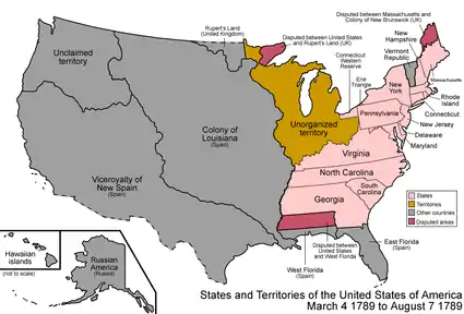
An enlargeable map of the United States after the Constitution of the United States was ratified on March 4, 1789.
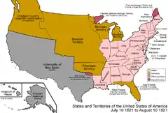
An enlargeable map of the United States after the Treaty of Córdoba was signed on August 24, 1821.
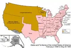
An enlargeable map of the United States after the Treaty of Guadalupe Hidalgo was signed on February 2, 1848.
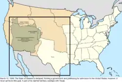
An enlargeable map of the United States after the creation of the proposed State of Deseret on July 2, 1849.

An enlargeable map of the United States after the creation of the Territory of New Mexico and the Territory of Utah on September 9, 1850.
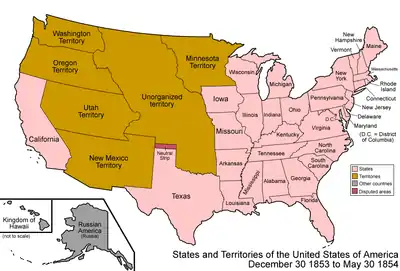
An enlargeable map of the United States after Gadsden Purchase on December 30, 1853.
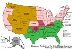
An enlargeable map of the United States after the creation of the Territory of Colorado on February 28, 1861.
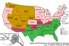
An enlargeable map of the United States after the creation of the Confederate Territory of Arizona on February 24, 1862.
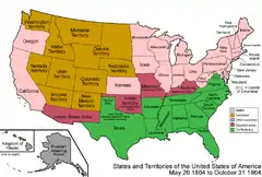
An enlargeable map of the United States after the creation of the Territory of Arizona on June 19, 1862.

An enlargeable map of the United States after the annexation of northwestern Arizona on January 18, 1867.


Timeline
- Historical territorial claims of Spain in the present State of Arizona:
- Nueva Vizcaya, 1562-1821
- Santa Fé de Nuevo Méjico, 1598-1821
- Sonora y Sinaloa, 1732-1821
- Treaty of Córdoba of 1821
- Historical territorial claims of Mexico in the present State of Arizona:
- Santa Fé de Nuevo México, 1821-1848
- Sonora y Sinaloa (Estado de Occidente), 1824-1830
- Sonora since 1830
- Treaty of Guadalupe Hidalgo of 1848
- Gadsden Purchase of 1853
- Historical political divisions of the United States in the present State of Arizona:
- Unorganized territory created by the Treaty of Guadalupe Hidalgo, 1848-1850
- State of Deseret (extralegal), 1849-1850
- Territory of New Mexico, 1850-1912
- Gadsden Purchase of 1853
- American Civil War, 1861-1865
- Arizona Territory (CSA), 1861-1865
- Territory of Arizona, 1863-1912[1]
- North-western corner of the Arizona Territory is transferred to the State of Nevada, 1867
- State of Arizona since February 14, 1912
- Mexican Boundary Exchanges: In 1927 under the Banco Convention of 1905, the U.S. acquired two bancos from Mexico at the Colorado River border with Arizona. Farmers Banco, covering 583.4 acres (2.361 km2), a part of the Cocopah Indian Reservation at 32°37′27″N 114°46′45″W, was ceded to the U.S. with controversy.[2] Fain Banco (259 acres (1.05 km2)) at 32°31′32″N 114°47′28″W also became U.S. soil.
See also
References
- Thirty-seventh United States Congress (February 24, 1863). "An Act to provide a temporary Government for the Territory of Arizona, and for other Purposes". Retrieved June 5, 2009.
- Decisions of the Department of the Interior in cases relating to the public lands: 1927-1954. United States. Department of the Interior. Washington. For sale by the Supt. of Docs., U.S. Govt. Print. Off. pp. 25, 337. hdl:2027/mdp.39015084910804.
External links

This article is issued from Wikipedia. The text is licensed under Creative Commons - Attribution - Sharealike. Additional terms may apply for the media files.
