Territorial evolution of Colorado
The following chronology traces the territorial evolution of the U.S. State of Colorado.
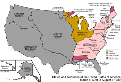
An enlargeable map of the United States after the Constitution of the United States was ratified on March 4, 1789.
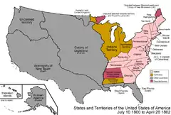
An enlargeable map of the United States after the secret Third Treaty of San Ildefonso transferred the Spanish colony of la Luisiana to the French Republic on October 1, 1800.
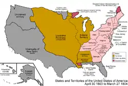
An enlargeable map of the United States after the Louisiana Purchase took effect on December 20,1803.
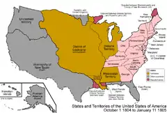
An enlargeable map of the United States after the creation of the District of Louisiana on March 26, 1804.
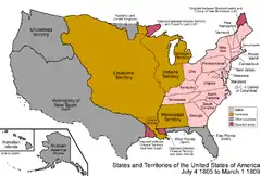
An enlargeable map of the United States after the creation of the Territory of Louisiana on March 3, 1805.
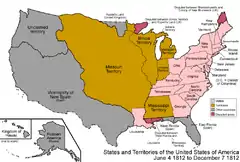
An enlargeable map of the United States after the creation of the Territory of Missouri on June 4, 1812.
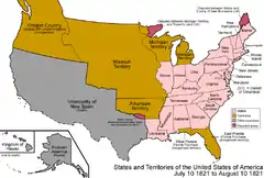
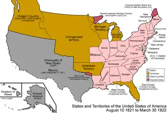
An enlargeable map of the United States after the Adams–Onís Treaty took effect on February 22, 1821.
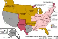
Territorial claims of the Republic of Texas, May 2, 1836.
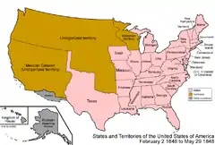
An enlargeable map of the United States after the Treaty of Guadalupe Hidalgo was signed on February 2, 1848.
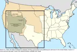
An enlargeable map of the United States after the creation of the proposed State of Deseret on July 2, 1849.

An enlargeable map of the United States after the creation of the Territory of New Mexico and the Territory of Utah on September 9, 1850.
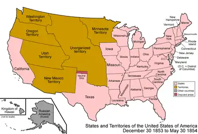
An enlargeable map of the United States after Gadsden Purchase on December 30, 1853.

An enlargeable map of the United States after the creation of the Territory of Kansas and the Territory of Nebraska on May 30, 1854.
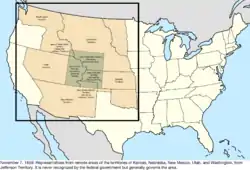
An enlargeable map of the United States after the creation of the proposed Territory of Jefferson on October 24, 1859.
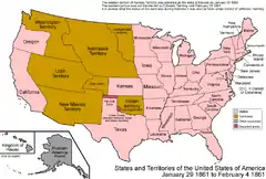
An enlargeable map of the United States after the creation of the Territory of Colorado on February 28, 1861.


Timeline
- Historical territorial claims of Spain in the present State of Colorado:
- Nueva Vizcaya, 1562–1821
- Santa Fé de Nuevo Méjico, 1598–1821
- Treaty of Córdoba of 1821
- Historical territorial claims of France in the present State of Colorado:
- Louisiane, 1682–1764
- Historical territorial claims of Spain in the present State of Colorado:
- Luisiana, 1764–1803
- Third Treaty of San Ildefonso of 1800
- Luisiana, 1764–1803
- Historical territorial claims of France in the present State of Colorado:
- Louisiane, 1803
- Vente de la Louisiane of 1803
- Louisiane, 1803
- Historical territorial claims of Mexico in the present State of Colorado:
- Santa Fé de Nuevo México, 1821–1848
- Treaty of Guadalupe Hidalgo of 1848
- Santa Fé de Nuevo México, 1821–1848
- Historical territorial claims of the Republic of Texas in the present State of Colorado:
- Disputed territory between the Arkansas River and the Rio Grande, 1836–1845
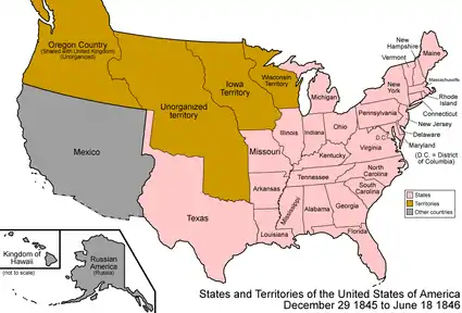
- Texas Annexation of 1845
- Disputed territory between the Arkansas River and the Rio Grande, 1836–1845
- Historical political divisions of the United States in the present State of Colorado:
- Unorganized territory created by the Louisiana Purchase, 1803–1804
- District of Louisiana, 1804–1805
- Territory of Louisiana, 1805–1812
- Territory of Missouri, 1812–1821
- Adams–Onís Treaty of 1819
- Unorganized territory previously the western portion of the Missouri Territory, 1821–1854
- Disputed territory created by the Texas Annexation, 1845–1850
- Unorganized territory created by the Treaty of Guadalupe Hidalgo, 1848–1850
- State of Deseret (extralegal), 1849–1850
- Territory of New Mexico, 1850–1912
- Territory of Utah, 1850–1896
- Territory of Kansas, 1854–1861
- Territory of Nebraska, 1854–1867
- Territory of Jefferson (extralegal), 1859–1861
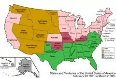
- Unorganized territory previously the western portion of the Kansas Territory, 1861
- Territory of Colorado, 1861–1876[1]
- State of Colorado since August 1, 1876[2][3]
See also
- History of Colorado
- Indigenous peoples of the North American Southwest
- Territorial evolution of the United States
 Santa Fe de Nuevo México
 La Louisiane
- La Luisiana
 Louisiana Purchase
- District of Louisiana
 Louisiana Territory
- Missouri Territory
 Mexican Empire
 Republic of Texas
- U.S. provisional government of New Mexico
- State of Deseret
 Utah Territory
 New Mexico Territory
 Kansas Territory
 Nebraska Territory
- Jefferson Territory
 Colorado Territory
- State of Colorado
References
- Thirty-sixth United States Congress (February 28, 1861). "An Act To provide a temporary Government for the Territory of Colorado" (PDF). Retrieved October 7, 2020.
- Forty-third United States Congress (March 3, 1875). "An act to enable the people of Colorado to form a constitution and State government, and for the admission of the said State into the Union on an equal footing with the original States" (PDF). Retrieved October 7, 2020.
- Ulysses S. Grant (August 1, 1876). "Proclamation 230—Admission of Colorado into the Union". The American Presidency Project. Retrieved October 7, 2020.
External links

This article is issued from Wikipedia. The text is licensed under Creative Commons - Attribution - Sharealike. Additional terms may apply for the media files.