Transport in Glasgow
The city of Glasgow, Scotland has a transport system encompassing air, rail, road, and an underground rail line. Prior to 1962, the city was also served by trams. Commuters travelling into Glasgow from the neighbouring local authorities of North and South Lanarkshire, Renfrewshire, East Renfrewshire and West Dunbartonshire have a major influence on travel patterns, with tens of thousands of residents commuting into the city each day.[1] The most popular mode of transport in the city is the car, used by two thirds of people for journeys around the city.[2]

The streets in the centre of Glasgow are organised in a grid-iron pattern laid out in the early 19th century, with streets running north to south and east to west.
Transport authorities
Glasgow's transport network is administered by a number of authorities. Transport Scotland is responsible for the construction, expansion and maintenance of trunk roads and motorways within the city (such as the M8, M73, M74 and M77 motorways), with the city government, Glasgow City Council responsible for all other roads. The Strathclyde Partnership for Transport is responsible for strategic transport planning for the region, including coordinating services amongst the various private bus operators and also operates the Glasgow Subway.The local rail network is operated by Abellio ScotRail.
Airports
Glasgow has two international airports and also served by a seaplane terminal.
Glasgow International Airport (GLA) is the closest airport to the city and handle the majority of Glasgow's air traffic across its two terminals. This includes shuttle flights to and from London and the rest of the UK, continental flights to various cities in Europe and long-haul transatlantic links to cities such as New York, Cancún, Orlando, and several Canadian cities in addition to Dubai.
The airport was opened in 1966 and typically handles over 10 million passengers a year, making it the second busiest airport in Scotland and the ninth-busiest airport in the United Kingdom.
The airport sits to the west of the city in Renfrewshire and is connected to the city via the M8 motorway.
Glasgow Prestwick Airport (PIK) is located 29 miles south west of the city in South Ayrshire and focuses on short-haul leisure flights to Europe, low-cost airlines and freight traffic. Prestwick is Scotland's fifth busiest airport in terms of passenger numbers, but its largest in terms of land area.
Glasgow also has a Seaplane Terminal located in the city centre on the River Clyde. This offers services to the Scottish islands and the far north.
There are also two small airfields in the nearby towns of Cumbernauld, North Lanarkshire and Strathaven, South Lanarkshire.
Motorway network

Glasgow is the focal point of Scotland's motorway network, which link it to the rest of the country. The motorways form a box around the city, comprising the M74 (to the south), the M8 (to the west and north) and the M73 (to the east). Additionally, the M77, M80 and M898 provide further links to the south west and north east of the city. The network is heavily used at peak times and represents one of the most comprehensive in the United Kingdom, connecting the city centre with the rest of the sprawling Greater Glasgow area.
M8
The M8 is Scotland's busiest motorway running from Greenock to the west of the city through to the capital, Edinburgh 60 miles to the east. The motorway was built in sections starting in 1964 and was finally completed in 2017. The city centre stretch of the M8 was originally planned to form part of a wider Glasgow Inner Ring Road, a proposed ring road encircling the city. The inner ring road plans were later abandoned, however a similar motorway ring around the city was later completed in 2017 as part of the M74 extension.
The motorway begins at Junction 1 in the west of Edinburgh and travels westwards through West Lothian and North Lanarkshire to the outskirts of the city. Previously the section of road between Junction 6 and 8 in North Lanarkshire was incomplete and not built to motorway standard. The road instead used a small section of the A8, however in 2017 the gap was finally closed with a new six lane motorway built to connect both sides of the M8. From here onwards, the M8 connects to the M73 at Townhead junction before running through the north of the city and skirting around the city centre.
The character of the M8 is somewhat unique compared to other motorways in the UK, featuring illuminated overhead gantries, high mast lighting and exits and entrances to the motorway on the right and left hand side. The road circles the city centre on an elevated viaduct, before dipping down through Charing Cross and then rising again to cross the River Clyde on the Kingston Bridge, Glasgow. The bridge is 10 lanes wide and is the busiest road crossing in Europe, with traffic volumes of up to 150,000 vehicles per day.
After the bridge, the M8 merges with the M74 becoming one of the widest stretches of road in the UK, with 16 lanes of traffic providing connections between the M8, M74 and M77 motorways.
M73
The M73 acts as a link between the M74 and the M8 in the east of the city, allowing traffic to change between the two motorways as they run east to west. Construction began in 1969 with the M73 opening in 1972. In 2011, the M73 was extended north to link up with the M80, forming a motorway triangle to the north of the city. In 2015, as part of the M8 M73 M74 Motorway Improvement Project, additional lanes were added to the southern part of the M73 making the southern part of the route four to five lanes wide in both directions.
M74
The M74 runs from the city centre through the south east of the city, acting as a major route into the city for the Lanarkshire suburbs where it connects to the M73 and expands to five lanes in each direction. It then turns to the south and continues to England. The M74 is Scotland's only motorway link to the rest of the United Kingdom and as such is one of the key cross-border routes between Scotland and England. Although the entire road is commonly referred to as the M74, it later becomes the A74(M) and then the M6 upon entering England.
Construction of the M74 began in 1964, and by 1999 the motorway stretched to Gretna, Dumfries and Galloway. The M74's northern extension was completed in the late 2010s, finalising the original plan of a southern motorway across the city.
M77
The M77 begins in Glasgow at the M8 motorway and runs south west to Ayrshire.
M80
The M80 runs between Glasgow and Stirling, via Cumbernauld. The M80 begins in the north of the city, diverging from the M8 motorway and heading north east eventually linking up with the M73. The road was constructed in three sections, the first opening in 1974, followed by further sections in 1992 and 2011.
M898
The M898 connects the M8 in the far west of the city to the Erskine Bridge. It is the highest numbered motorway in the UK, and also the shortest being less than half a mile long.
The Bruce Report
The construction of Glasgow's motorway network was originally proposed as part of the Bruce Report, which set out an ambition for a modern, efficient transport network for the city. This included miles of new motorway, bridges, tunnels and railway and resulted in the creation of the M8, M74 and M77 roads as well as the Clyde Tunnel and Clydeside Expressway. The implementation of the Bruce Report was at the time controversial, however in recent times it has been recognised as contributing to Glasgow's relatively low level of inner-city congestion and low journey times for people travelling across the city.
Whilst many projects from the Bruce Report were implemented, some remain incomplete to this day. Of note is the final part of the city's inner ring road which was meant to complete a motorway box around the city centre.
As of 2020, this is unlikely to ever be completed as in 2008, the Scottish Government began construction of the M74 northern extension through the south-eastern part of Glasgow following a similar route to the south west portion of the inner ring road. The extension connected the M74 to the M8 forming a motorway box around the city similar to, but slightly larger than that originally envisioned in the Bruce Report. The extension opened to traffic in 2011 and succeeded in its goals of reducing traffic on the congested M8 and improving safety and journey times around the city.
Following the completion of the M74 northern extension, the city has now started construction on the Glasgow East End Regeneration Route which will connect the M74 northern extension with the M8 motorway at the M80 interchange forming a second, smaller box closer to the city centre. Phase 1 and 2 of the project are complete, with phase 3 currently under construction.
Other Roads
In addition to the motorways, there are numerous other important roads across the city. Some are trunk roads - key strategic routes maintained by the central government.
A82
The A82 runs from the city centre to the north eastern fringes of the city. Within the city, the A82 is known as the 'Great Western Road'. Once leaving the city, the A82 continues northwards onto Loch Lomond and the north west Highlands.
A725
The A725 is a cross-Lanarkshire route connecting the towns of East Kibride, Hamilton, Bellshill and Coatbridge to the A726, M74, M8 and A8 roads. It acts as a southern and eastern bypass for the city of Glasgow and has been upgraded frequently since its construction, the most recent of which was in 2018.
The A725 begins to the east of the city, where it diverges from the M8 at the Shawhead Junction. It links with the M8 and A8 in a complex, partially grade-separated junction and then travels south and links with the M74 at the Raith Interchange in a triple-layer junction with a stacked roundabout. The A725 continues south west through Hamilton to East Kilbride, where it links with the A726. The A725 acts as a strategic link for the large towns of North and South Lanarkshire, as well as catering for more strategic traffic travelling between the M8 and M74 motorways.
The first section of the route to be developed was the Bellshill Bypass (the northern section) completed in 1968. The southern section, known as the EK Expressway, was completed in two parts. The first part in East Kilbride was completed as part of the work to transform the settlement into a New Town in 1967, with the final section through Hamilton completed in 1978.
The Raith Interchange was considerably upgraded between 2014 and 2017 to address traffic congestion issues occurring as a result of partial lack of grade separation between the A725 and M74.
A726
The A726 acts as a southern orbital route of Glasgow, starting at East Kilbride and continuing to the M77 in the south west of the city. It allows traffic from Lanarkshire, the south and the M8 to travel to Ayrshire and the M77 without having to travel through the city centre motorway network.
A737
The A737 is one of the key routes from Glasgow to Ayrshire. The road leaves the M8 motorway at Linwood Interchange and runs for six miles to the south-west. It connects the towns of Johnstone, Kilbarchan and those further south to the city centre.
A739
The A739 is a busy road linking the western districts of Glasgow. It starts at the M8 motorway in the west of the city and travels north through the Clyde Tunnel to the north eastern part of Glasgow. It acts as an important distributor road for the west of the city, connecting the A814 to the M8 motorway and offering an alternative river crossing to the west of the city centre.
A814 (Clydeside Expressway)
The A814 (known as the Clydeside Expressway) is an inner city expressway. It starts at the west end of the city centre and follows the river westwards. The road forms an essential arterial route connecting the west end of the city to the centre. Construction on the expressway started in 1971 taking around 24 months, with the road opening to traffic in April 1973. The Expressway includes many over and underpasses which are designed in typical Glasgow style using prestressed concrete beams fabricated on site. Unlike most motorways in Scotland, corner radii were set at 150 feet, and the road has a unique electric road heating system installed which, during the winter months, is used to reduce the need to grit.
The Expressway has a number of unique grade separated junctions designed to enable efficient movement of traffic whilst minimising land take.
Whiteinch Interchange is an example of such a junction, designed to allow traffic to move freely between the Expressway and the Clyde Tunnel. The design of this junction created a challenge as it was a requirement that it should be completely free flowing whilst also not taking any land from the nearby Victoria Park. The final design involves a partial-cloverleaf where traffic from opposing directions temporarily share carriageway space when moving around the interchange.
The Clyde Tunnel
The Clyde Tunnel was the first modern road crossing of the River Clyde. Plans for a tunnel were put in place as far back as the 1940s. Construction began in 1957 and the tunnel was completed six years later. The tunnel carries over 60,000 vehicles per day and is an essential north-south link for commuters travelling across Glasgow.
The tunnel has four lanes for traffic and connects with the Clydeside Expressway in the north end. To the south, it continues as an expressway to connect to the M8 motorway.
Rail
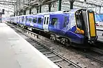
Glasgow has one of the densest heavy rail networks in the United Kingdom outside London, with 186 stations across the Greater Glasgow area. The suburban railway is run by Abellio ScotRail and is centered around the two main terminus stations, Glasgow Central station and Glasgow Queen Street railway station.
Glasgow Central primary serves routes to the south of the city, such as those in Lanarkshire, Ayrshire and links to the rest of the United Kingdom. Queen Street services tend to run east to west across the city, with additional services serving the north of Scotland.
Plans were devised in the post-war period to redevelop Glasgow as a whole. As part of the resulting "Bruce Report", it was proposed that Queen Street Station be demolished and replaced as a bus station and garage. Under this scheme, only the low-level Queen Street Station would be kept, as part of the suburban rail system, and a new purpose-built Glasgow North Station would be constructed on the site of Buchanan Street station. This plan was never followed through, and Queen Street operates to this day, although Buchanan Street station closed in the 1960s. The chosen site for the Glasgow North Station is now occupied by the Buchanan bus station, the Buchanan Galleries shopping centre, the Royal Concert Hall, and the Glasgow Passport Office. Glasgow and District Transport Plans from 1951 show the layout of the proposed station, available on: Hipkiss' Scanned Old Maps.
Previously, two other terminus stations served Glasgow. St Enoch railway station was sited on St Enoch Square, a few blocks away from Central Station whilst Buchanan Street railway station was sited at the north end of the street bearing the same name. Both stations were removed in the 1960s as a result of the Beeching cuts. The St. Enoch Centre was built on the site of the old St Enoch Station in the 1980s, and Buchanan House, headquarters of Transport Scotland and Glasgow Caledonian University now stand on the site formerly occupied by Buchanan Street station.
Future Plans
Locals have long pressed for a link which will join the two halves of the urban railway network together, making possible through journeys via the central area without having to disembark at either Central or Queen Street and traverse the city centre by foot or road. The Glasgow Crossrail initiative has been on the drawing board for many years but still awaits funding from central government, despite the favourable outcomes of a feasibility study carried out in 2003.
Plans to connect Glasgow to London by a 270 mph (430 km/h) Transrapid (German Maglev train) emerged in June 2005. However, this proposal was shelved in favour of the proposed High Speed 2 scheme from London to Birmingham, which may be extended to Glasgow.
There were also plans to connect Glasgow city with Glasgow International Airport, via a new rail link which was estimated to bring around 700 new jobs to the Paisley area. The Act of Parliament authorizing construction of the link was passed by the Scottish Parliament on 29 November 2006 and received Royal Assent on 15 January 2007. It was expected that the link would be in operation by 2013, but it was canceled by the Scottish Parliament in 2009 as a cost-cutting measure.
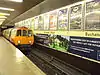
Glasgow Subway
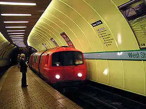
Glasgow is one of only three British metropolitan areas that has an underground metro system; the others being London and Newcastle. The Glasgow Subway (previously Glasgow Underground), was built in 1896 and substantially modernized in 1977. It has a single circular route. This, taken together with the orange-coloured paintwork of the carriages, has led to it being known, by guidebooks more than the locals who still refer to it as the "Subway", as "The Clockwork Orange" after the 1971 film.
Despite being the third oldest subway system in the world (after London's and Budapest's), it has never been expanded beyond its original route. Reasons given for this have invariably related to Glasgow's geology: the tunnels are excavated from rock, and for this reason they are also smaller than London's. An SPT study into a possible expansion of the subway has been mooted. It would extend further into the West End, East End and Southside of the city which may cost up to £800million to build. Much of this expansion might utilize disused railway tunnels that have been abandoned since the Beeching cuts of the 1960s.
Bus
Deregulation of bus services began in October 1986, since that time bus operators have been able to start new services, change services, or cancel existing services by giving 42 days notice to the relevant authorities; in Scotland this has since changed to 56 days notice with an additional 14-day consultation period over and above this. Operation of non commercial services that SPT deem to be socially necessary may be awarded by competitive tender.
A number of 'bus corridors' have been invested in by Glasgow City Council focusing on main bus routes with real time information, and bus priority measures. The Greater Glasgow Passenger Transport Executive (GGPTE), formerly the municipal transport operator, is now privately owned by First Glasgow.
The largest bus operators in the City are:
- First Glasgow - who are the successors to the former Glasgow Corporation Transport Department, and the former Central and Kelvin subsidiaries of the Scottish Bus Group.
- McGill's Bus Services - The successors to the former Arriva Scotland West. McGill's took over on 26 March 2012.
- Stagecoach Glasgow - The successors to the former Western subsidiary of the Scottish Bus Group, with their Stagecoach Glasgow company competing on several city routes.
- Glasgow Citybus - Independent company providing services in the North West Glasgow area.
Buchanan bus station is owned and run by SPT, and is a terminus for both local and long-distance services
Other transport
Glasgow has a well developed network of park and ride sites operated by SPT[3] or Scotrail. These exist at railway and subway stations across the greater Glasgow area. The Glasgow Subway has three park and ride sites with a total of 1,109 spaces with at least 10,000 further spaces spread out across the local rail network.
Glasgow also has a bike sharing scheme launched in the city in 2014.
Historical Transport
Glasgow Tramways
Glasgow had for many years an extensive system of trams that ran on the city's streets alongside other traffic. It was one of the largest in Europe. However, by the 1950s much of the vehicle stock was over 30 years old and in need of replacement. The trams were becoming less used as car use increased, and gradually the tram network was phased out across the city, including many routes that were still fairly well used and reckoned to be economically viable. The last tram in the city ran on 4 September 1962; some 250,000 people lined the streets to watch. It was the last city tram network in Britain until 1992.
In the mid 1990s there emerged a plan to create a Strathclyde Tram Project, which would have seen the reintroduction of trams to Glasgow. Strathclyde Passenger Transport published a set of plans for this system, going so far as to distribute pamphlets across the city outlining these plans and the proposed routes. The initial line proposed was a 20-kilometre route run from Maryhill in the Northwest of the city to Easterhouse on Glasgow's Eastern fringe. It was envisaged that the line would use disused railway lines and tunnels as well as running in part on some roads in the city alongside other traffic. The plan then outlined future expansion of the tram network so that it might one day stretch across the Greater Glasgow area.
However, there were a number of objections to these proposals, amongst them from Strathclyde Bus Holdings, who it could be argued did so out of fear of their profit margins being affected by such an initiative. This necessitated a public inquiry, which lasted around 10 weeks. The Parliamentary Commissioners appointed to deliberate on the matter met and discussed the conclusions of this inquiry in a matter of hours before finding in favour of the objections raised thus killing off the Strathclyde Tram Project. The reasoning of the Commissioners is unknown as there existed no obligation for them to reveal it.[4]
There is a proposal to reintroduce trams (again, as in 1996, this would actually be a light rail system) to Glasgow. This came in light of similar proposals, completed in 2014, to reintroduce trams to Edinburgh. The City of Glasgow Council and SPT have commissioned a £500,000 study into the viability of such a system, which would initially operate from the city centre to the new Glasgow Harbour site then across the River Clyde to the Southern General Hospital and through Govan and along the south bank of the Clyde before crossing the river again back into the city centre. There are proposals to run trams further than this route out to the Braehead shopping centre and possibly Glasgow Airport; to Clydebank; and across the rest of the city.
Presently SPT has decided that this route will not see trams running along it, but rather an "ultra-modern" bus service termed "Clyde Fastlink" will operate part of the route, running from the city centre to the Glasgow Harbour area.[5] SPT has stated however that it is leaving open the option of laying tram lines on this route and replacing the buses with a light rail system.
Trolleybuses
Glasgow Corporation Transport Department also operated a small trolleybus system between 1949 and 1967, using electricity generated from the same power station as the trams.
See also
- Transport in Scotland
- Traveline Scotland, with bus, train and ferry information
- Glasgow Transport employee uniform badges & history
- Glasgow Transport history pages
References
- "NRS Scotland Transport" (PDF).
- "Scottish Government Census - Transport".
- "Park and Ride in the SPT area". Strathclyde Partnership for Transport. Retrieved 19 July 2020.
- Light Rail Transit Association Archived 20 July 2011 at the Wayback Machine
- Glasgow Harbour Website

| History |  | |
|---|---|---|
| Politics | ||
| Geography | ||
| Culture | ||
| Transport | ||
| Education | ||
| Religion | ||
| Sport | ||
| Attractions |
| |
| Health | ||
| ||