Transportation in Taiwan
The Ministry of Transportation and Communications governs transportation in Taiwan.
Land transport

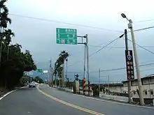
Roads
- Total length: 41,475 km (2009)
- National highway: 901 km
- Provincial highway: 4,680 km
- Highways: 20,947 km (including 872 km of freeways)
- Urban roads: 16,395, km
Rail
Total: 1,580 km (2009) (all on the island of Taiwan)
- Taiwan Railways Administration: 1,097 km of 1,067 mm (3 ft 6 in) gauge
- Taiwan High Speed Rail: 354 km of 1,435 mm (4 ft 8 1⁄2 in) gauge
- Kaohsiung Mass Rapid Transit: 51.8 km of 1,435 mm (4 ft 8 1⁄2 in) gauge
- Taipei Metro: 131.1 km of 1,435 mm (4 ft 8 1⁄2 in) gauge
- Taoyuan Metro: 51.03 km of 1,435 mm (4 ft 8 1⁄2 in) gauge
- Taiwan Sugar Corporation: 240 km of 762 mm (2 ft 6 in) gauge
- Forestry Bureau: 86 km of 762 mm (2 ft 6 in) gauge
High-speed rail
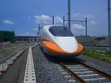
The Taiwan High Speed Rail (THSR) commenced operations on 5 January 2007, after some delays in 2006. The THSR connects Taipei City in the northeast of the island of Taiwan to Kaohsiung City in the southwest. The journey time is about 90 minutes compared to 4 hours by conventional rail. 30 Shinkansen Class 700T sets are running on the 345 km HSL, with station stops at Taipei Main station, Panchiao, Taoyuan, Hsinchu, Taichung, Chiayi, Tainan and Tsuoying near Kaohsiung. Four additional stations have been opened: Nankang in eastern Taipei, Miaoli, Changhua and Yunlin. In 2008 THSR increased the number of trains to 88 per day, each way.
The Shinkansen 700T is similar to the Japanese 700 Nozomi. It operates in 12 car sets (9 powered, 3 trailers) at a speed limit of 300 km/h over standard gauge 1,435 mm (4 ft 8 1⁄2 in) track. OCS power is 25 kV AC 60 Hz.
Conventional rail
Urban transit
There are four urban transit systems in Taiwan: Taipei Metro, New Taipei Metro, Taoyuan Metro, and Kaohsiung Rapid Transit. Taichung Metro is under construction.
Taipei Metro opened in 1996 and runs on an extensive network of both Multiple Unit for the high-capacity system as well as VAL for the medium-capacity system throughout the metropolitan area of Taipei. The metro system operates 11 lines consisting of 109 stations.[1]
Kaohsiung Rapid Transit opened in 2008 and runs a metro network throughout the metropolitan area of Kaohsiung. The Red and Orange lines opened on 9 March and 14 September, 2008 respectively. Future lines are planned in order to parts of Greater Kaohsiung as well as Pingtung County.
The Taoyuan Metro is a metro system with one operational line, and four in planning. (Airport MRT, red, green, orange, brown).[2] The Airport MRT serves Taoyuan, Taipei and New Taipei after it opened in March 2017.
Taichung Metro is currently under construction to create a metro network for Taichung. The network will serve the Changhua and Nantou counties. The metro will start off with 3 main lines (green, blue, and red), with four other lines planned. The Green line is scheduled to be completed in 2020.[3]
The Tainan Mass Rapid Transit System (台南捷運) was postponed by the Ministry of Transportation and Communications in January 2010 due to fear of insufficient riders and construction costs. The government has instead chosen to upgrade current rail systems and buses.
The Hsinchu Mass Rapid Transit System (新竹捷運) was postponed by the Ministry of Transportation and Communications in January 2010 due to doubts about whether the transit system would be beneficial in the short term.
Air transport
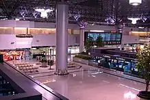
Airports
During the global COVID-19 pandemic traffic at Taiwan’s large international airports fell sharply while traffic to smaller domestic airports increased as a result of a surge in domestic tourism.[4]
Total: 40
Length of runways:
Airlines
Total: 7
Heliports
Total: 31 (2013)[5]
Sea transport
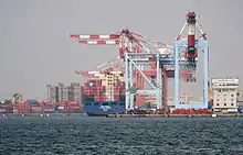
Ports
Major ports: Kaohsiung, Keelung, Taichung, Hualien
Other ports: Anping, Su'ao, Taipei
Merchant marine:
112 ships (1,000 GT or over) totaling 3,827,173 GT/6,121,877 tonnes deadweight (DWT) (2010)
ships by type:
- Bulk 35
- Cargo 20
- Chemical tanker 1
- Container 31
- Petroleum tanker 12
- Passenger/cargo 4
- Refrigerated cargo 7
- Roll on/roll off 2
Pipelines
As of 2013, Taiwan maintains the following pipelines[6]
- Condensate 25 km
- Gas 802 km
- Oil 241 km
References
- "Taipei Metro Networks and Systems". Taipei City Government. Archived from the original on 2013-10-21. Retrieved 2014-01-01.
- "Introduction to Airport MRT". Office of Rapid Transit Systems, Taoyuan. Retrieved 2016-12-28.
- "Taichung Mass Rapid Transit System". Taichung City Government. Retrieved 2014-01-01.
- Strong, Matthew. "Airports on small Taiwanese islands show growth for 2020". www.taiwannews.com.tw. Retrieved 2 February 2021.
- "CIA World Factbook".
- "The World Factbook". Central Intelligence Agency. Retrieved 1 January 2014.
| Wikimedia Commons has media related to Transport in Taiwan. |
| |||||||||||||||
| |||||||||||||||
| |||||||||||||||
| |||||||||||||||
Transport in Asia | |
|---|---|
| Sovereign states |
|
| States with limited recognition |
|
| Dependencies and other territories |
|
| |
| History |  | |
|---|---|---|
| Currency | ||
| Banking and finance | ||
| Government agencies | ||
| Research | ||
| Sectors | ||
| Industrial parks | ||
| Associations | ||
| Other | ||
| ||
| Road |
| ||||||
|---|---|---|---|---|---|---|---|
| Aviation |
| ||||||
| Maritime |
| ||||||
| Rail |
| ||||||
| Biking | |||||||
| |||||||