U.S. Route 6 in Iowa
U.S. Highway 6 (US 6) is an east–west U.S. Highway which runs 319 miles (513 km) across the U.S. state of Iowa. The route is signed in places as the Grand Army of the Republic Highway. Like all state highways in Iowa, it is maintained by the Iowa Department of Transportation. The route begins at the Missouri River crossing at Council Bluffs. From there, it travels east through Oakland and Atlantic. North of Atlantic, the highway overlaps Interstate 80 (I-80) until De Soto. Between De Soto and Adel, the highway overlaps US 169 before splitting off to the east towards Des Moines. Through the Des Moines area, the highway runs about one mile (1.6 km) north or south of the I-35 / I-80 corridor.
| |||||||
|---|---|---|---|---|---|---|---|
| Grand Army of the Republic Highway | |||||||

US 6 highlighted in red | |||||||
| Route information | |||||||
| Maintained by Iowa DOT | |||||||
| Length | 322.655 mi[1] (519.263 km) | ||||||
| Existed | June 8, 1931[2]–present | ||||||
| Major junctions | |||||||
| West end | |||||||
| East end | |||||||
| Location | |||||||
| Counties | |||||||
| Highway system | |||||||
| |||||||

At Altoona, the route again overlaps I-80 until Newton, where it splits away from I-80. The highway passes near or through the cities of Kellogg, Grinnell, Victor, Marengo, the Amana Colonies, and Tiffin before entering the Coralville / Iowa City area. Through Coralville and Iowa City, US 6 has no direct access to I-80, I-380, or US 218; other routes like Iowa Highway 1 (Iowa 1) and Iowa 965 provide direct access. From Iowa City, the highway heads to the east-southeast through West Liberty and Atalissa. Near Wilton, the route heads north to I-80 where it again overlaps to Davenport. At Davenport, US 6 then follows I-280 and US 61 before entering the city. On the eastern side of Davenport, it joins I-74 and enters Bettendorf before leaving Iowa for Illinois.
Dating back to 1910, the route US 6 follows was originally the Great White Way and River-to-River Road. Both were auto trails which connected Council Bluffs and Davenport. When the U.S. Highway System was created in 1926, the highway was designated U.S. Highway 32. US 32 was renumbered in 1931 as US 6 was extended to the west coast. As the Interstate Highway System expanded in the 1950–1970s, US 6's importance as a cross-state route was diminished by I-80. As a result, the least-traveled sections of the route were moved onto I-80 and control of the vacated sections of highway was given to local jurisdictions.
Route description
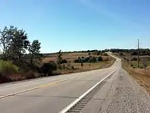
US 6 is a cross-state route that connects Council Bluffs and Davenport by way of Des Moines and Iowa City. The route parallels I-80 for most of its length; however nearly one-third of the route overlaps the Interstate Highway. While the route is away from I-80, US 6 is a two-lane highway with a rural speed limit of 55 miles per hour (90 km/h). However, between Adel and Waukee, the roadway is a four-lane divided highway that has a speed limit of 65 mph (105 km/h).[3]
Western Iowa
US 6 crosses the Missouri River via the Grenville Dodge Memorial Bridge into Council Bluffs with I-480. Just three-quarters mile (1.2 km) into the state, I-480 ends at an interchange with I-29. US 6 heads east along I-29 south on the western side of Council Bluffs, then it overlaps I-80 and continues due east. On the east side of Council Bluffs, I-80 and US 6 split. Near Oakland, the highway follows the north–south US 59 for two miles (3.2 km). Near Lewis, the road turns to the north-northeast until it reaches Atlantic. In Atlantic, the route turns back to the east and heads towards downtown where it meets Iowa 83. US 6 / Iowa 83 travel together to the eastern side of Atlantic where they meet US 71. The three routes run together for four miles (6.4 km), when US 6 / US 71 split away from Iowa 83 and continue north to I-80. At I-80, US 6 leaves US 71 and joins I-80. At this point, US 6 begins the first of three instances when its traffic is routed along I-80. In the eastern part of Cass County, the two routes meet the northern end of Iowa 148.[4]
As I-80 and US 6 approach Adair, and the highways curve slightly to the south to bypass the community. There are two interchanges in Adair; both of the intersecting roads, at one time or another, carried US 6. County Road G30 (CR G30), the White Pole Road, was the original alignment of US 6,[5] while CR N54 has not carried US 6 since 1980.[6][7] Further east is an interchange with Iowa 25. About one mile (1.6 km) south of the interchange is Freedom Rock. Each year for Memorial Day, the rock is repainted with a patriotic scene by local artist Ray "Bubba" Sorenson II.[8] Near Dexter, I-80 and US 6 graze the northwestern corner of Madison County. After two miles (3.2 km), the routes enter Dallas County and meet CR F60, another former alignment of US 6.[9] Near the CR F90 / CR P58 interchange, they start heading northeast towards Des Moines. At De Soto, US 6 splits away from I-80 at the interchange with US 169.[4]
Central Iowa
At De Soto, US 6 turns to the north, overlapping US 169 for five miles (8.0 km) to Adel. East of Adel, US 6 is a four-lane divided highway for 14 miles (23 km), during which, it passes through Waukee, Clive, and Urbandale along Hickman Road, and intersects I-35 / I-80. Over the next two miles (3.2 km), it serves as the border between Urbandale and Windsor Heights. At 63rd Street in Des Moines, US 6 intersects Iowa 28. For one-half mile (800 m), US 6 / Iowa 28 run together on Hickman Road. Turning north, they run together for another mile (1.6 km) along Merle Hay Road. At Douglas Avenue, US 6 splits away from Iowa 28 and continues east, becoming Euclid Avenue just west of the Des Moines River. In north-central Des Moines, it intersects US 69 and I-235. In northeast Des Moines, it turns to the northeast along Hubbell Avenue, which takes US 6 to Altoona. West of Altoona, it intersects US 65 and continues northeast passing Adventureland theme park and Prairie Meadows casino. In northwest Altoona, US 6 intersects I-80 and US 65.[4] Here, US 6 rejoins I-80 for the second time. After a third exit for Altoona, the interstate resumes its 70 mph (115 km/h) rural limit. Near Colfax, the highways cross the South Skunk River. After an interchange with Iowa 117, the highway is forced to the north to avoid crossing the river multiple times. As the roadway returns south to its original line, it meets CR F48, which was another former alignment of US 6.[6]
At Newton, US 6 splits away from I-80 at the Iowa 14 interchange. US 6 overlaps Iowa 14 for one-third mile (540 m). It turns off of Iowa 14 and enters the western side of Newton where it passes the Jasper County courthouse located in the downtown area. Between Newton and Grinnell, the route has more hills and curves. The highway crosses the North Skunk River near Kellogg. At Grinnell, it intersects Iowa 146 southwest of the Grinnell College campus. East of Grinnell, the route straightens out and is overlapped by US 63 for two miles (3.2 km) and by Iowa 21 for four miles (6.4 km).[1] Near Victor, US 6 takes a northeasterly course through Ladora towards Marengo. At Marengo, it intersects the eastern end of Iowa 212. Five miles (8.0 km) east of Marengo is the western end of Iowa 20. Here, US 6 forms the southern leg of the Amana Colonies Trail. Three miles (4.8 km) later, it's joined by US 151 for two miles (3.2 km). US 6 heads to the southeast towards Tiffin and passes underneath I-380, but does not have direct access.[4]
Eastern Iowa
At Coralville, US 6 passes underneath I-80, but one-half mile (800 m) to the east, Coral Ridge Avenue provides direct access to I-80. Entering Iowa City, the highway passes the campus of the University of Iowa, its main hospital, and VA Hospital. US 6 curves to the south to be adjacent to the Iowa River, where it meets and overlaps Iowa 1 for one-half mile (800 m). US 6 and Iowa 1 go in separate directions at a signal controlled intersection, where, less than one-quarter mile (400 m) away, US 6 crosses the Iowa River. From Iowa City, it heads in an east-southeast direction towards West Liberty. The highway enters West Liberty from the northwest corner and curves southward. At the northern end of Iowa 70, it turns to the east again towards Atalissa and Wilton. Ten miles (16 km) southwest of Wilton, the road crosses the Cedar River. Three miles (4.8 km) south of Wilton, the highway overlaps Iowa 38 and the two routes head towards I-80. At the Wilton interchange along I-80, Iowa 38 turns west and US 6 turns east onto the interstate, respectively.[1]
As I-80 and US 6 approach the Quad Cities metropolitan area, the speed limit drops again to 65 mph (105 km/h).[10] Just within the city limits of Davenport is the I-280 interchange. US 6 exits to the south to join I-280. US 61 also joins I-280 at this interchange, but from the opposite direction. US 6 only overlaps I-280 / US 61 for four-fifths mile (1.3 km) before exiting onto Kimberly Road. Heading southeast into Davenport, US 6 is a two-lane highway for three miles (4.8 km). At Fairmount Street, it becomes a four-lane divided highway and straightens out to head due east. Near NorthPark Mall, it intersects Northwest Boulevard, which becomes Iowa 130 at I-80, and both one-way legs, Welcome Way southbound and Brady Street northbound, of US 61 Business, which prior to 2010 was US 61.[11][12] US 6 briefly dips to the southeast and straightens out again towards I-74. The highway joins I-74 and heads to the south towards Moline, Illinois.[1] For about one mile (1.6 km), I-74 / US 6 forms the boundary of Davenport and Bettendorf.[4] The two routes completely enter Bettendorf and descend into the Mississippi River valley, where they meet US 67 at a complex series of exit and entrance ramps. They then ascend the Iowa-Illinois Memorial Bridge, known locally as the I-74 Bridge, and cross the Mississippi River into Illinois.[4]
History
Before the U.S. Highway System came into being in 1926, roads in Iowa were maintained and promoted by local organizations which sought to drive traffic into their communities. Two such organizations created virtually parallel routes connecting Council Bluffs and Davenport via Des Moines. The routes, the southern Great White Way and northern River-to-River Road, eventually merged into the Whiteway-7-Highway. The new route followed the Great White Way from Council Bluffs to Des Moines and the River-to-River Road from Des Moines to Davenport.[13] In 1926, the Whiteway-7-Highway became US 32, which itself became US 6 in 1931.[2] For a time, US 6 was the busiest highway in the state.[14] After I-80 was built near US 6, portions of the U.S. Highway were moved onto the Interstate Highway. Interest in the original US 6 corridor has grown in the 21st century by people who seek to drive traffic back into their communities.
Great White Way/White Pole Road
| |
|---|---|
| Location | Council Bluffs–Davenport |
| Length | 340 mi[13] (550 km) |
| Existed | July 30, 1914–September 21, 1922[13] |
The Great White Way was formed in 1910 by the White Pole Auto Club. The route was built along the Chicago, Rock Island & Pacific Railroad between Council Bluffs and Des Moines. Members of the auto club painted poles along the route white, which lead the route to be known as the White Pole Road. The Great White Way passed through Oakland, Atlantic, Adair, De Soto, and Valley Junction. In late 1912, the Great White Way was extended east to Davenport, passing through Pella, Oskaloosa, Washington, and Muscatine.[15] In 1913, when the Iowa State Highway Commission began registering named trails longer than 25 miles (40 km), the Great White Way Association paid the $5.00 fee ($129.00 in 2019 dollars[16]) to become the first official registered highway route on July 30, 1914.[13] When the primary highway system was created, the Great White Way was assigned Primary Road No. 2.[17]
In 2002, a group of residents from Adair, Casey, Menlo, Stuart, and Dexter formed a new group to promote the White Pole Road. Their intention was to bring visitors to their towns by diverting some traffic from the nearby I-80 / US 6 corridor to the south and onto the historic road. Poles were painted white up to nine feet (2.7 m) high line along the 26-mile (42 km) drive. White Pole Road logo signs in each town give a short history of the town and their founders.[18]
River-to-River Road
| |
|---|---|
| Location | Council Bluffs–Davenport |
| Length | 316 mi[13] (509 km) |
| Existed | April 16, 1918[13]–November 11, 1926 |
The River-to-River Road (RRR) was also created in 1910 and also connected Council Bluffs and Davenport via Des Moines. This route, however, traveled a more northern route than the Great White Way. The route passed through Neola, Elk Horn, Guthrie Center, Adel, Des Moines, Newton, Marengo, Iowa City, and Wilton.[15] The route's origins trace back to the 1909–10 winter season which brought, on average, 11 inches (28 cm) of snow more than the previous year, which was followed by an unusually dry spring.[19] Coupled with the advent of the Ford Model T, many Iowans complained about the lack of good roads in the state.[20] Governor B.F. Carroll convened a Good Roads convention on March 8–9, 1910, to discuss the condition of roads in his state. It was then that the route of the RRR was decided among the convention delegates. Further influencing the River-to-River corridor was an announcement from the American Automobile Association that the annual Glidden Tour would pass through Iowa. Gov. Carroll arranged for farmers who lived along the route to drag all 380 miles (610 km) of the road on the Saturday prior to the tour's arrival at precisely 9 am.[21] Work was finished in one hour.[22]
When the highway commission started accepting registered routes, the RRR association planned to register their route as soon as possible. But miscommunication between association members and with the highway commission delayed the actual registration for years.[23] The route became official on April 16, 1918.[13] When the primary highway system was created, the River-to-River Road was assigned Primary Road No. 7.[17]
Whiteway-7-Highway
| Whiteway-7-Highway | |
|---|---|
| Location | Chicago, Ill.–Omaha, Neb. |
| Existed | September 21, 1922[13]–November 11, 1926[2] |
In 1922, the Whiteway-7-Highway Association filed an application to register the Whiteway-7-Highway with the Iowa State Highway Commission. The commission was concerned with the Whiteway-7's similarity to the Great White Way's name and route markings. The Great White Way was marked with a 6-foot-wide (1.8 m) stripe, while the Whiteway-7 would be marked with a 4-foot (1.2 m) stripe with a black circle containing a white seven. Another concern with the new route was since its name contained the number seven, the route would be assigned along Primary Road Nos. 2 and 7. On September 25, 1922, the highway commission gave the Great White Way from Des Moines to Council Bluffs, which would become part of the Whiteway-7-Highway, the number 7 and gave the River-to-River Road's western half number 2.[24] Eight months later, the Iowa State Highway Commission reversed course and restored Primary Road Nos. 2 and 7 to their original roadways. Although disappointed, the Whiteway-7-Highway Association responded by removing the number from their name. On November 27, 1925, the route officially became the Whiteway Highway.[25]
U.S. Numbered Highways
| |
|---|---|
| Location | Council Bluffs–Davenport |
| Length | 322 mi[26] (518 km) |
| Existed | November 11, 1926–June 8, 1931[2] |
On November 11, 1926, members of the American Association of State Highway Officials approved the plan to create a system of interstate highways across the country. Iowa's Whiteway Highway would take on the designation of US 32. For four-and-a-half years, US 32 spanned from Chicago to Council Bluffs. Meanwhile, Roosevelt Highway Association was pushing to have US 6 extended westward.[24] On June 8, 1931, all of the Iowa portion of US 32 was absorbed into a newly extended US 6, which had previously connected Erie, Pennsylvania, and Cape Cod. The new US 6 also replaced US 38 in Nebraska and Colorado. By the end of 1937, US 6 extended from coast to coast.[2] At the time, it and US 30 were the only cross country highways to bear a single route number across the country.[27]
When the last segment of highway between Adel and Des Moines was paved in 1931, US 6 became the fourth paved road to cross the state.[28] In the early 1940s, US 6 was the most heavily traveled route in the state. The state highway commission recorded that on average, over 1900 vehicles used the road per day at any rural point.[14] That compares to nearly 3000 vehicles using US 6 daily in 2012.[1]
On April 29, 1947, the Iowa General Assembly approved an act designating US 6 as the Grand Army of the Republic Highway, a distinction the route shares in other states.[29] Governor Robert D. Blue dedicated the G.A.R. Highway at the Old Capitol on September 28, 1947. In attendance were the last two surviving Iowa veterans of the Civil War.[30] In the 1950s, the Iowa State Highway Commission began to straighten the route. A section of the highway between Grinnell and Ladora was straightened, which resulted in Brooklyn and Victor being bypassed.[31] Between Dexter and West Des Moines, US 6 swapped alignments with Iowa 90 in 1958.[32] In 1961, US 6 was routed onto the new Interstate 80 from the Iowa 90 interchange to the Baxter exit, currently exit 159. Iowa 90 was extended onto the old US 6 alignment.[33] However, in 1967, those changes were reversed and US 6 was taken off I-80 and put back on the road which had been Iowa 90. Iowa 90 was assigned the section of US 6 between what's now exit 106 along I-80 and exit 69 along I-35.[34][35]
Abandoned sections
Since the 1970s, portions of US 6 have been moved permanently onto I-80. The first section, between US 71 and Adair, was rerouted in 1972. The abandoned section became an extended Iowa 83 and CR G30 in Adair County.[36] In 1980, three lengthy sections were moved onto the Interstate: 26 miles (42 km) in western Iowa between Adair and Dexter,[37] 25 miles (40 km) in central Iowa between Altoona and Newton,[38] and 20 miles (32 km) in eastern Iowa between Wilton and Davenport.[39] All three sections were originally kept as state highways, but in 1991, when the Iowa Department of Transportation first showed the new state highways' designations on the state highway map, the central section already had been turned over to Polk and Jasper counties. The western segment was numbered Iowa 925 and the eastern segment Iowa 927.[40]
On July 1, 2003, 15 miles (24 km) between Dexter and Adel were turned over to Dallas County.[41] US 6, which had previously split away from I-80 at the Dexter exit, was continued along I-80 to the US 169 interchange at De Soto, and then along US 169 to Adel. The former segments, Iowa 925 and Iowa 927, were turned over to their respective counties as well.[42][43]
Major intersections
| County | Location | mi[1] | km | Exit[4] | Destinations | Notes |
|---|---|---|---|---|---|---|
| Missouri River | 0.000 | 0.000 | Continuation into Nebraska | |||
| Grenville Dodge Memorial Bridge; Nebraska–Iowa state line | ||||||
| Pottawattamie | Council Bluffs | 0.274 | 0.441 | 0 | Riverfront | Eastbound exit and westbound entrance; exit number follows I-480 |
| 0.721 | 1.160 | — | Council Bluffs | Eastbound left exit and westbound left entrance; former US 6 east | ||
| 53B | Eastern end of I-480 overlap; western end of I-29 overlap; exit numbers follow I-29 | |||||
| 1.299 | 2.091 | 53A | 9th Avenue / Harrah's Boulevard – Casino | |||
| 2.120 | 3.412 | 52 | Nebraska Avenue – Riverboat Casino, Dog Track-Casino | |||
| 2.854 | 4.593 | 51 | Eastern end of I-80 Local overlap; eastbound exit and westbound entrance | |||
| 3.815 | 6.140 | 50 | S. 24th Street – Council Bluffs, Mid-America Center | |||
| 5.268 | 8.478 | 49 | South Expressway – Council Bluffs, Business District, Lake Manawa | Former Iowa 192 north | ||
| 3.837 | 6.175 | 48 4 | Eastern end of I-29 and I-80 Local overlaps; western end of I-80 overlap; signed as exit 4 eastbound; I-29 north exits 48A-B | |||
| 7.309 | 11.763 | 5 | Madison Avenue – Council Bluffs | |||
| 10.683 | 17.193 | 8 | Eastern end of I-80 overlap | |||
| Belknap Township | 30.626 | 49.288 | Western end of US 59 overlap | |||
| Oakland | 33.030 | 53.157 | Eastern end of US 59 overlap | |||
| Cass | Cass Township | 45.879 | 73.835 | |||
| Atlantic | 56.227 | 90.489 | Western end of Iowa 83 overlap | |||
| 57.803 | 93.025 | Western end of US 71 overlap | ||||
| Grove Township | 59.803 | 96.244 | Eastern end of Iowa 83 overlap | |||
| Pymosa Township | 66.249 | 106.617 | 60 | Eastern end of US 71 overlap; western end of I-80 overlap; exit numbers follow I-80 | ||
| Benton Township | 70.235 | 113.032 | 64 | |||
| Grant Township | 75.967 | 122.257 | 70 | |||
| Adair | Adair | 81.229 | 130.725 | 75 | ||
| 81.968 | 131.915 | 76 | ||||
| Casey | 88.399 | 142.264 | 83 | |||
| Jefferson Township | 91.898 | 147.895 | 86 | |||
| 93.887 | 151.096 | 88 | ||||
| Stuart | 98.882 | 159.135 | 93 | |||
| Adair–Madison county line | Lincoln–Penn township line | 102.882 | 165.573 | 97 | ||
| Dallas | Dexter | 105.788 | 170.249 | 100 | Former US 6 | |
| Adams Township | 109.665 | 176.489 | 104 | |||
| 112.061 | 180.345 | 106 | ||||
| De Soto | 115.540 | 185.944 | 110 | Eastern end of I-80 overlap; western end of US 169 overlap | ||
| Adel | 120.910 | 194.586 | Eastern end of US 169 overlap | |||
| Polk | Clive–Urbandale city line | 133.404 | 214.693 | I-80 exit 125 | ||
| Des Moines | 137.191 | 220.788 | Western end of Iowa 28 overlap | |||
| 138.504 | 222.901 | Eastern end of Iowa 28 overlap | ||||
| 142.560 | 229.428 | |||||
| 143.565 | 231.045 | |||||
| 144.881 | 233.163 | I-235 exit 12 | ||||
| Des Moines–Altoona city line | 148.579 | 239.115 | Interchange | |||
| Altoona | 149.921 | 241.274 | 142 | Western end of I-80 overlap | ||
| Altoona–Bondurant city line | 151.562 | 243.915 | 143 | Altoona, Bondurant | Exit numbers follow I-80 | |
| Mitchellville | 156.698 | 252.181 | 149 | Mitchellville | ||
| Jasper | Colfax | 163.049 | 262.402 | 155 | ||
| Sherman Township | 166.722 | 268.313 | 159 | |||
| Newton | 172.156 | 277.058 | 165 | Eastern end of I-80 overlap; western end of Iowa 14 overlap | ||
| 173.246 | 278.812 | Eastern end of Iowa 14 overlap | ||||
| Kellogg Township | 182.272 | 293.338 | ||||
| Poweshiek | Grinnell | 192.580 | 309.927 | |||
| Malcom Township | 199.652 | 321.309 | Western end of US 63 overlap | |||
| 201.691 | 324.590 | Eastern end of US 63 overlap | ||||
| Warren Township | 211.702 | 340.701 | Western end of Iowa 21 overlap | |||
| Iowa | Hartford Township | 215.935 | 347.514 | Eastern end of Iowa 21 overlap | ||
| Marengo | 227.046 | 365.395 | ||||
| Amana Colonies | 232.808 | 374.668 | ||||
| 235.859 | 379.578 | Western end of US 151 overlap | ||||
| 237.801 | 382.704 | Eastern end of US 151 overlap | ||||
| Johnson | Coralville | 252.849 | 406.921 | |||
| Iowa City | 257.130 | 413.811 | Western end of Iowa 1 overlap | |||
| 257.870 | 415.002 | Eastern end of Iowa 1 overlap | ||||
| Muscatine | West Liberty | 274.637 | 441.985 | |||
| Moscow–Wilton township line | 286.218 | 460.623 | Western end of Iowa 38 overlap | |||
| Cedar | Sugar Creek Township | 291.120 | 468.512 | 271 | Eastern end of Iowa 38 overlap; western end of I-80 overlap | |
| Farmington Township | 297.184 | 478.271 | 277 | Bennett, Durant | Exit numbers follow I-80 | |
| Scott | Cleona Township | 300.217 | 483.152 | 280 | ||
| Walcott | 304.452 | 489.968 | 284 | |||
| Davenport | 310.110 | 499.074 | 290 | Eastern end of I-80 overlap; western end of I-280/US 61 overlap | ||
| 310.934 | 500.400 | 1 | Eastern end of I-280/US 61 overlap; exit number follows I-280 | |||
| 317.323 | 510.682 | One-way street | ||||
| 317.464 | 510.909 | One-way street | ||||
| Davenport–Bettendorf city line | 320.064 | 515.093 | 2 | Western end of I-74 overlap; exit numbers follow I-74 | ||
| Bettendorf | 321.139 | 516.823 | 3 | Middle Road | ||
| 321.892– 322.974 | 518.035– 519.776 | 4 | ||||
| Mississippi River | 322.655 | 519.263 | I-74 Bridge; Iowa–Illinois state line | |||
| Continuation into Illinois | ||||||
1.000 mi = 1.609 km; 1.000 km = 0.621 mi
| ||||||
References
- 2011 Volume of Traffic on the Primary Road System of Iowa (PDF) (Report). Iowa Department of Transportation. January 1, 2011. Retrieved May 26, 2012.
- Weingroff, Richard F. "U.S. 6 – The Grand Army of the Republic Highway". Federal Highway Administration. Retrieved September 26, 2010.
- Staff (February 8, 2010). "What Are the Legal Speed Limits?" (PDF). Iowa Department of Transportation. Retrieved October 6, 2013.
- Transportation Map (PDF) (Map). Iowa Department of Transportation. 2013. Retrieved October 6, 2013.
- Iowa State Highway Commission (June 1932). State of Iowa Transportation Map (PDF) (Map). Ames: Iowa State Highway Commission. § L7–M9. Retrieved August 9, 2012.
- Iowa State Highway Map (PDF) (Map). Iowa Department of Transportation. 1980. § D3. Retrieved August 9, 2012.
- Iowa State Highway Map (PDF) (Map). Iowa Department of Transportation. 1981. § D3. Retrieved August 9, 2012.
- Banusiewicz, John D. (November 17, 2003). "Artist Turns Iowa Graffiti Rock into Military Tribute". United States Department of Defense News. Washington, D.C.: American Forces Press Service. Retrieved August 9, 2012.
- Iowa State Highway Map (PDF) (Map). Iowa Department of Transportation. 2003. § E3. Retrieved October 6, 2012.
- Quad Cities Interstate Speed Limits (Map). Iowa Department of Transportation. July 1, 2005. Archived from the original on April 8, 2013. Retrieved August 12, 2012.
- "Application for Recognition of a Business Route on U.S. Route 61" (PDF). American Association of State Highway and Transportation Officials. April 12, 2010. Retrieved December 27, 2013.
- "US Route Numbering Report to the Standing Committee on Highways" (PDF). American Association of State Highway and Transportation Officials. May 20, 2010. Retrieved December 27, 2013.
- Iowa Department of Transportation. "Iowa Registered Routes". Retrieved September 26, 2010.
- Staff (May 5, 1941). "Highway No. 6 found to be Iowa's most-traveled road". Des Moines Tribune.
- Iowa Registered Highway Routes 1914–1925 (PDF) (Map). Iowa Department of Transportation. 1986. Retrieved September 25, 2010.
- Federal Reserve Bank of Minneapolis. "Consumer Price Index (estimate) 1800–". Retrieved January 1, 2020.
- Rand McNally & Company (1926). Junior Road Map: Western Iowa (Map). Chicago: Rand McNally & Company. Retrieved September 26, 2010 – via Broer Map Library.
- Perry, Tom (September 8, 2007). "White Pole Road exudes Americana". The Des Moines Register. Retrieved October 6, 2013.
- Iowa Department of Agriculture (1911). 1910 Iowa Year Book of Agriculture. 11. Des Moines, Iowa: Emory H. English. pp. 6–12. Retrieved October 14, 2013.
- Adolphus, David (January 2011). "Iowa's River to River Road". Hemmings Motor News. Retrieved October 14, 2013.
- The Class Journal Company (July 7, 1910). "Built 380 Miles of Road in One Hour". The Automobile. The Class Journal Company. p. 37. Retrieved October 14, 2013.
- Bruce, Robert (October 1910). Touring in Central West. American Motorist. American Automobile Association. pp. 426–427. Retrieved October 14, 2013.
- Iowa Department of Transportation. "History of the River To River Road". Retrieved September 27, 2010.
- Miller, Bryce (August 4, 2002). "Iowa's Forgotten Highway". The Des Moines Register. p. 4F.
- Iowa Department of Transportation. "Whiteway-7". Retrieved September 27, 2010.
- "Service Bulletin". Iowa State Highway Commission. October–December 1925: 3. Cite journal requires
|journal=(help) - Staff (January 3, 1937). "Extension for Highway No. 6". The Des Moines Register.
- Clifton, C.C. (November 15, 1931). "Four Paved Roads Now Cross Iowa". The Des Moines Register.
- "G.A.R. Highway". Acts and resolutions passed at the 52nd session of the General Assembly of the state of Iowa. Iowa General Assembly. 1947. pp. 187–188. Retrieved September 27, 2010.
- Staff (September 29, 1947). "Make No. 6 Highway of the G.A.R.". The Des Moines Register.
- Iowa State Highway Commission (1957). State of Iowa Transportation Map (PDF) (Map). Ames: Iowa State Highway Commission. Retrieved September 27, 2010.
- Iowa State Highway Commission (1959). State of Iowa Transportation Map (PDF) (Map). Ames: Iowa State Highway Commission. Retrieved September 27, 2010.
- Iowa State Highway Commission (1962). State of Iowa Transportation Map (PDF) (Map). Ames: Iowa State Highway Commission. Retrieved September 27, 2010.
- Iowa State Highway Commission (1966). State of Iowa Transportation Map (PDF) (Map). Ames: Iowa State Highway Commission. Retrieved December 27, 2013.
- Iowa State Highway Commission (1967). State of Iowa Transportation Map (PDF) (Map). Ames: Iowa State Highway Commission. Retrieved September 27, 2010.
- Iowa State Highway Commission (1973). State of Iowa Transportation Map (PDF) (Map). Ames: Iowa State Highway Commission. Retrieved September 29, 2010.
- Google (September 29, 2010). "Overview of Iowa 925" (Map). Google Maps. Google. Retrieved September 29, 2010.
- Google (September 29, 2010). "Overview of Iowa 926" (Map). Google Maps. Google. Retrieved September 29, 2010.
- Google (September 29, 2010). "Overview of Iowa 927" (Map). Google Maps. Google. Retrieved September 29, 2010.
- Iowa Department of Transportation (1991). State of Iowa Transportation Map (PDF) (Map). Ames: Iowa Department of Transportation. Retrieved December 27, 2013.
- Petroski, William (July 1, 2003). "Road Transfer Draws Worry". The Des Moines Register. p. B1.
- Iowa Department of Transportation (2003). State of Iowa Transportation Map (PDF) (Map). Ames: Iowa Department of Transportation. Retrieved December 27, 2013.
- Iowa Department of Transportation (2004). State of Iowa Transportation Map (PDF) (Map). Ames: Iowa Department of Transportation. Retrieved September 29, 2010.
External links
- Iowa division of the U.S. Route 6 Tour Association
- The White Pole Road
- River to River: Iowa's Forgotten Highway 6
| Previous state: Nebraska |
Iowa | Next state: Illinois |