Iowa County, Iowa
Iowa County is a county located in the U.S. state of Iowa. As of the 2010 census, the population was 16,355.[1] The county seat is Marengo.[2]
Iowa County | |
|---|---|
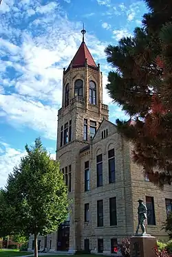 Iowa County Courthouse in Marengo | |
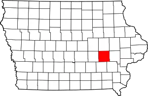 Location within the U.S. state of Iowa | |
 Iowa's location within the U.S. | |
| Coordinates: 41°41′10″N 92°04′01″W | |
| Country | |
| State | |
| Founded | 1843 |
| Named for | Iowa River |
| Seat | Marengo |
| Largest city | Williamsburg |
| Area | |
| • Total | 587 sq mi (1,520 km2) |
| • Land | 586 sq mi (1,520 km2) |
| • Water | 1.0 sq mi (3 km2) 0.2% |
| Population (2010) | |
| • Total | 16,355 |
| • Estimate (2018) | 16,141 |
| • Density | 28/sq mi (11/km2) |
| Time zone | UTC−6 (Central) |
| • Summer (DST) | UTC−5 (CDT) |
| Congressional district | 1st |
| Website | www |
Iowa County is one of seven counties in the United States to share the same name as the state they are located in. The other six counties are Arkansas County, Hawaii County, Idaho County, New York County, Oklahoma County, and Utah County.[3]
History
Iowa County was formed on February 17, 1843. It was named for the Iowa River, which flows through the county.[4]
The first courthouse was a log cabin built in 1847. This was rented by the county until 1850 when a second courthouse was completed. In 1861 construction of a third courthouse was begun. The current courthouse was built in 1892 after the county had outgrown the previous one.[5]
Iowa County is home to the Amana Colonies, a group of settlements of German Pietists, comprising seven villages. Calling themselves the Ebenezer Society or the Community of True Inspiration (German: die Gemeinde der wahren Inspiration), they first settled in New York state near Buffalo in what is now West Seneca. However, in order to live out their beliefs in more isolated surroundings they moved west, to Iowa County in 1855, living a communal life until the mid-1930s. Today, Amana is a major tourist attraction known mainly for its restaurants and craft shops, and the colonies as a whole have been listed as a National Historic Landmark since 1965.
Geography
According to the U.S. Census Bureau, the county has a total area of 587 square miles (1,520 km2), of which 586 square miles (1,520 km2) is land and 1.0 square mile (2.6 km2) (0.2%) is water.[6]
The county is intersected by the Iowa River and the north fork of the English River.[7]
Major highways
Adjacent counties
- Benton County (north)
- Linn County (northeast)
- Johnson County (east)
- Washington County (southeast)
- Keokuk County (south)
- Poweshiek County (west)
- Tama County (northwest)
Demographics
| Historical population | |||
|---|---|---|---|
| Census | Pop. | %± | |
| 1850 | 822 | — | |
| 1860 | 8,029 | 876.8% | |
| 1870 | 16,644 | 107.3% | |
| 1880 | 19,221 | 15.5% | |
| 1890 | 18,270 | −4.9% | |
| 1900 | 19,544 | 7.0% | |
| 1910 | 18,409 | −5.8% | |
| 1920 | 18,600 | 1.0% | |
| 1930 | 17,332 | −6.8% | |
| 1940 | 17,016 | −1.8% | |
| 1950 | 15,835 | −6.9% | |
| 1960 | 16,396 | 3.5% | |
| 1970 | 15,419 | −6.0% | |
| 1980 | 15,429 | 0.1% | |
| 1990 | 14,630 | −5.2% | |
| 2000 | 15,671 | 7.1% | |
| 2010 | 16,355 | 4.4% | |
| 2018 (est.) | 16,141 | [8] | −1.3% |
| U.S. Decennial Census[9] 1790-1960[10] 1900-1990[11] 1990-2000[12] 2010-2018[1] | |||
2010 census
The 2010 census recorded a population of 16,355 in the county, with a population density of 27.8881/sq mi (10.7677/km2). There were 7,258 housing units, of which 6,677 were occupied.[13]
2000 census
As of the census[14] of 2000, there were 15,671 people, 6,163 households, and 4,301 families residing in the county. The population density was 27 people per square mile (10/km2). There were 6,545 housing units at an average density of 11 per square mile (4/km2). The racial makeup of the county was 98.70% White, 0.17% Black or African American, 0.06% Native American, 0.30% Asian, 0.03% Pacific Islander, 0.36% from other races, and 0.38% from two or more races. 0.97% of the population were Hispanic or Latino of any race.
There were 6,163 households, out of which 32.80% had children under the age of 18 living with them, 60.10% were married couples living together, 6.60% had a female householder with no husband present, and 30.20% were non-families. 25.90% of all households were made up of individuals, and 12.50% had someone living alone who was 65 years of age or older. The average household size was 2.50 and the average family size was 3.03.
In the county, the population was spread out, with 26.40% under the age of 18, 6.30% from 18 to 24, 27.80% from 25 to 44, 22.40% from 45 to 64, and 17.10% who were 65 years of age or older. The median age was 39 years. For every 100 females there were 95.00 males. For every 100 females age 18 and over, there were 93.20 males.
The median income for a household in the county was $41,222, and the median income for a family was $48,946. Males had a median income of $31,220 versus $24,652 for females. The per capita income for the county was $18,884. About 3.40% of families and 5.00% of the population were below the poverty line, including 4.50% of those under age 18 and 5.40% of those age 65 or over.
Politics
In the 2008 US presidential election, a nearly equal number of Iowa County voters voted for each major candidate.[15]
| Year | Republican | Democratic | Third parties |
|---|---|---|---|
| 2016 | 58.5% 5,205 | 34.6% 3,084 | 6.9% 615 |
| 2012 | 51.5% 4,569 | 46.7% 4,144 | 1.7% 153 |
| 2008 | 49.0% 4,188 | 49.2% 4,202 | 1.9% 158 |
| 2004 | 53.8% 4,544 | 45.4% 3,841 | 0.8% 69 |
| 2000 | 52.5% 3,894 | 43.6% 3,230 | 3.9% 289 |
| 1996 | 43.2% 3,042 | 47.7% 3,354 | 9.1% 639 |
| 1992 | 38.1% 2,656 | 36.8% 2,560 | 25.1% 1,749 |
| 1988 | 48.6% 3,247 | 49.9% 3,338 | 1.5% 100 |
| 1984 | 60.0% 4,352 | 38.8% 2,815 | 1.2% 84 |
| 1980 | 55.2% 4,153 | 34.7% 2,606 | 10.2% 763 |
| 1976 | 53.0% 3,926 | 45.4% 3,367 | 1.6% 118 |
| 1972 | 60.3% 4,202 | 37.0% 2,578 | 2.6% 184 |
| 1968 | 58.1% 4,133 | 36.4% 2,586 | 5.5% 392 |
| 1964 | 39.8% 2,828 | 60.0% 4,261 | 0.2% 13 |
| 1960 | 63.5% 4,944 | 36.3% 2,828 | 0.2% 18 |
| 1956 | 62.7% 4,875 | 35.4% 2,753 | 1.9% 149 |
| 1952 | 67.3% 5,625 | 30.1% 2,514 | 2.7% 223 |
| 1948 | 52.4% 3,659 | 43.4% 3,030 | 4.1% 289 |
| 1944 | 53.9% 3,959 | 42.5% 3,119 | 3.6% 262 |
| 1940 | 55.3% 4,696 | 43.0% 3,649 | 1.7% 143 |
| 1936 | 43.6% 3,360 | 54.0% 4,163 | 2.5% 189 |
| 1932 | 35.0% 2,628 | 58.4% 4,376 | 6.6% 495 |
| 1928 | 56.9% 4,091 | 42.7% 3,075 | 0.4% 30 |
| 1924 | 51.9% 3,549 | 21.3% 1,458 | 26.8% 1,830 |
| 1920 | 69.9% 4,892 | 28.9% 2,019 | 1.2% 86 |
| 1916 | 57.9% 2,484 | 41.1% 1,763 | 1.0% 43 |
| 1912 | 30.8% 1,237 | 45.8% 1,841 | 23.5% 944 |
| 1908 | 52.6% 2,230 | 45.0% 1,907 | 2.5% 104 |
| 1904 | 52.8% 2,303 | 43.4% 1,891 | 3.8% 167 |
| 1900 | 52.7% 2,336 | 44.7% 1,983 | 2.6% 114 |
| 1896 | 53.8% 2,391 | 44.0% 1,956 | 2.2% 99 |
Communities
Census-designated places
Other unincorporated communities
- Genoa Bluff
- Koszta
Townships
Population ranking
The population ranking of the following table is based on the 2010 census of Iowa County.[17]
† county seat
| Rank | City/Town/etc. | Municipal type | Population (2010 Census) |
|---|---|---|---|
| 1 | Williamsburg | City | 3,068 |
| 2 | † Marengo | City | 2,528 |
| 3 | North English (partially in Keokuk County) | City | 1,041 |
| 4 | Victor (partially in Poweshiek County) | City | 893 |
| 5 | Middle Amana | CDP | 581 |
| 6 | Amana | CDP | 442 |
| 7 | Ladora | City | 283 |
| 8 | Conroy | CDP | 259 |
| 9 | Parnell | City | 193 |
| t-10 | Millersburg | City | 159 |
| t-10 | South Amana | CDP | 159 |
| 11 | Homestead | CDP | 148 |
| 12 | West Amana | CDP | 135 |
| 13 | High Amana | CDP | 115 |
| 14 | East Amana | CDP | 56 |
Education
The following public school districts have areas in Iowa County:
- Belle Plaine Community School District, Belle Plaine
- Benton Community School District, Van Horne
- Clear Creek–Amana Community School District, Oxford
- Deep River–Millersburg Community School District, Millersburg
- English Valleys Community School District, North English
- H-L-V Community School District, Victor
- Iowa Valley Community School District, Marengo
- Williamsburg Community School District, Williamsburg
References
- "State & County QuickFacts". United States Census Bureau. Archived from the original on June 7, 2011. Retrieved July 17, 2014.
- "Find a County". National Association of Counties. Archived from the original on May 31, 2011. Retrieved June 7, 2011.
- Joseph Nathan Kane; Charles Curry Aiken (2005). The American Counties: Origins of County Names, Dates of Creation, and Population Data, 1950-2000. Scarecrow Press. ISBN 978-0-8108-5036-1.
- History
- Iowa County Archived July 20, 2008, at the Wayback Machine at Iowa State Association of Counties, retrieved July 26, 2008.
- "US Gazetteer files: 2010, 2000, and 1990". United States Census Bureau. February 12, 2011. Retrieved April 23, 2011.
- Ripley, George; Dana, Charles A., eds. (1879). . The American Cyclopædia.
- "Population and Housing Unit Estimates". Retrieved June 24, 2019.
- "U.S. Decennial Census". United States Census Bureau. Retrieved July 17, 2014.
- "Historical Census Browser". University of Virginia Library. Retrieved July 17, 2014.
- "Population of Counties by Decennial Census: 1900 to 1990". United States Census Bureau. Retrieved July 17, 2014.
- "Census 2000 PHC-T-4. Ranking Tables for Counties: 1990 and 2000" (PDF). United States Census Bureau. Retrieved July 17, 2014.
- "Population & Housing Occupancy Status 2010". United States Census Bureau American FactFinder. Retrieved May 18, 2011.
- "U.S. Census website". United States Census Bureau. Retrieved January 31, 2008.
- Local and National Election Results - Election Center 2008 , accessed June 16, 2012.
- Leip, David. "Dave Leip's Atlas of U.S. Presidential Elections". uselectionatlas.org. Retrieved April 26, 2018.
- "2010 U.S. Census website". United States Census Bureau. Retrieved January 18, 2017.
External links
| Wikimedia Commons has media related to Iowa County, Iowa. |
Places adjacent to Iowa County, Iowa | ||||||||||
|---|---|---|---|---|---|---|---|---|---|---|
| ||||||||||
Municipalities and communities of Iowa County, Iowa, United States | ||
|---|---|---|
| Cities | Map of Iowa highlighting Iowa County | |
| Townships | ||
| CDPs | ||
| Footnotes | ‡This populated place also has portions in an adjacent county or counties | |
| ||

| Authority control |
|---|