Madison County, Iowa
Madison County is a county located in the U.S. state of Iowa. As of the 2010 census, the population was 15,679.[1] The county seat is Winterset.[2]
Madison County | |
|---|---|
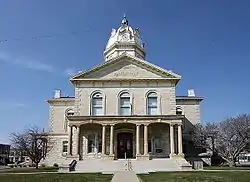 Madison County courthouse | |
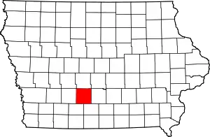 Location within the U.S. state of Iowa | |
 Iowa's location within the U.S. | |
| Coordinates: 41°20′N 94°01′W | |
| Country | |
| State | |
| Founded | 1846 |
| Named for | James Madison |
| Seat | Winterset |
| Largest city | Winterset |
| Area | |
| • Total | 562 sq mi (1,460 km2) |
| • Land | 561 sq mi (1,450 km2) |
| • Water | 1.2 sq mi (3 km2) 0.2% |
| Population (2010) | |
| • Total | 15,679 |
| • Estimate (2018) | 16,249 |
| • Density | 28/sq mi (11/km2) |
| Time zone | UTC−6 (Central) |
| • Summer (DST) | UTC−5 (CDT) |
| Congressional district | 3rd |
| Website | madisoncoia |
Madison County is included in the Des Moines–West Des Moines, IA Metropolitan Statistical Area.[3]
Madison County is famous for being the county where John Wayne was born, and for a number of covered bridges. These bridges were featured in Robert James Waller's 1992 novella The Bridges of Madison County, as well as the 1995 film and 2014 musical based on it.
History
Madison County was formed on January 13, 1846. It has been self-governed since 1849. It was named after James Madison (1751–1836), the fourth President of the United States (between 1809 and 1817).[4] Hiram Hurst, a suspected murderer, arsonist and hog thief was the first white settler in Madison County, having come from Missouri about April 15, 1846.[5]
Geography
According to the U.S. Census Bureau, the county has a total area of 562 square miles (1,460 km2), of which 561 square miles (1,450 km2) is land and 1.2 square miles (3.1 km2) (0.2%) is water.[6]
Major highways
 Interstate 80 (in the far northwestern corner of the county)
 U.S. Highway 6
.svg.png.webp) U.S. Highway 169
U.S. Highway 169 Iowa Highway 92
Adjacent counties
- Dallas County (north)
- Warren County (east)
- Clarke County (southeast)
- Union County (southwest)
- Adair County (west)
- Polk County (northeast)
Demographics
| Historical population | |||
|---|---|---|---|
| Census | Pop. | %± | |
| 1850 | 1,179 | — | |
| 1860 | 7,339 | 522.5% | |
| 1870 | 13,884 | 89.2% | |
| 1880 | 17,224 | 24.1% | |
| 1890 | 15,977 | −7.2% | |
| 1900 | 17,710 | 10.8% | |
| 1910 | 15,621 | −11.8% | |
| 1920 | 15,020 | −3.8% | |
| 1930 | 14,331 | −4.6% | |
| 1940 | 14,525 | 1.4% | |
| 1950 | 13,131 | −9.6% | |
| 1960 | 12,295 | −6.4% | |
| 1970 | 11,558 | −6.0% | |
| 1980 | 12,597 | 9.0% | |
| 1990 | 12,483 | −0.9% | |
| 2000 | 14,019 | 12.3% | |
| 2010 | 15,679 | 11.8% | |
| 2018 (est.) | 16,249 | [7] | 3.6% |
| U.S. Decennial Census[8] 1790-1960[9] 1900-1990[10] 1990-2000[11] 2010-2018[1] | |||
2010 census
The 2010 census recorded a population of 15,679 in the county, with a population density of 27.9413/sq mi (10.7882/km2). There were 6,554 housing units, of which 6,025 were occupied.[12]
2000 census
As of the census[13] of 2000, there were 14,019 people, 5,326 households, and 3,925 families in the county. The population density was 25 people per square mile (10/km2). There were 5,661 housing units at an average density of 10 per square mile (4/km2). The racial makeup of the county was 98.57% White, 0.09% Black or African American, 0.27% Native American, 0.18% Asian, 0.02% Pacific Islander, 0.19% from other races, and 0.68% from two or more races. 0.75% of the population were Hispanic or Latino of any race.
Of the 5,326 households 34.80% had children under the age of 18 living with them, 63.90% were married couples living together, 7.00% had a female householder with no husband present, and 26.30% were non-families. 22.70% of households were one person and 11.70% were one person aged 65 or older. The average household size was 2.58 and the average family size was 3.04.
The age distribution was 27.10% under the age of 18, 6.90% from 18 to 24, 27.40% from 25 to 44, 23.40% from 45 to 64, and 15.20% 65 or older. The median age was 38 years. For every 100 females, there were 97.40 males. For every 100 females age 18 and over, there were 93.10 males.
The median household income was $41,845 and the median family income was $48,289. Males had a median income of $31,126 versus $24,095 for females. The per capita income for the county was $19,357. About 4.60% of families and 6.70% of the population were below the poverty line, including 6.60% of those under age 18 and 10.40% of those age 65 or over.
Covered bridges
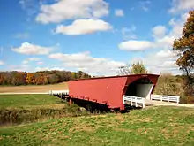
There are only six extant covered bridges in Madison County of the original nineteen:
- Cedar Bridge built 1883, destroyed 2002, rebuilt 2004, 76 feet (23 m) long. The rebuilt bridge was destroyed by a fire in 2017.
- Cutler-Donahoe Bridge built 1870, 79 feet (24 m) long.
- Hogback Covered Bridge built 1884, 97 feet (30 m) long.
- Holliwell Bridge built 1880, 122 feet (37 m) long. Featured in the 1995 movie The Bridges of Madison County.
- Imes Bridge built 1870, 81 feet (25 m) long.
- Roseman Covered Bridge built 1883, 107 feet (33 m) long. This is the best-known one, as it is featured in the 1995 movie The Bridges of Madison County.
The remaining covered bridges were designed by Harvey P. Jones and George K. Foster, with the following exceptions - Eli Cox built the Cutler-Donahoe Bridge, and J. P. Clark built the Imes Bridge.
Tunnel
Madison County is home to the only highway tunnel in Iowa, Harmon Tunnel, through the neck of an incised meander of the Middle River in Pammel Park.[14]
Communities
Townships
Population ranking
The population ranking of the following table is based on the 2010 census of Madison County.[15]
† county seat
| Rank | City/Town/etc. | Municipal type | Population (2010 Census) |
|---|---|---|---|
| 1 | † Winterset | City | 5,190 |
| 2 | Earlham | City | 1,450 |
| 3 | St. Charles | City | 653 |
| 4 | Truro | City | 485 |
| 5 | Patterson | City | 130 |
| 6 | East Peru | City | 125 |
| 7 | Macksburg | City | 113 |
| 8 | Bevington (partially in Warren County) | City | 63 |
Politics
For most of its history, Madison County has primarily supported the Republican Party in presidential elections. From 1896 to 1960, the county only failed to back the party's candidate in 1932 when Herbert Hoover was defeated in a national landslide for reelection by Franklin D. Roosevelt. The county was much more of a swing area between 1964 & 1996, voting for the national winner in every presidential election between 1964 & 2004 aside from 1988 when Michael Dukakis was boosted to an inflated margin of victory statewide by a farm crisis. Since the start of the second millennium, Republicans have carried the county in every presidential election. Donald Trump also produced the county's strongest Republican presidential victory since 1952 in 2016, winning by a margin of over 30 percent.
| Year | Republican | Democratic | Third Parties |
|---|---|---|---|
| 2020 | 66.2% 6,507 | 31.9% 3,134 | 1.9% 183 |
| 2016 | 62.1% 5,360 | 31.0% 2,678 | 6.9% 598 |
| 2012 | 54.8% 4,638 | 42.9% 3,630 | 2.3% 190 |
| 2008 | 54.0% 4,579 | 44.0% 3,733 | 2.0% 169 |
| 2004 | 56.7% 4,538 | 42.2% 3,380 | 1.1% 86 |
| 2000 | 52.6% 3,662 | 44.4% 3,093 | 3.1% 214 |
| 1996 | 40.3% 2,550 | 48.5% 3,070 | 11.2% 707 |
| 1992 | 39.4% 2,421 | 41.1% 2,525 | 19.6% 1,203 |
| 1988 | 41.1% 2,410 | 58.4% 3,421 | 0.5% 31 |
| 1984 | 50.6% 3,168 | 49.0% 3,067 | 0.4% 26 |
| 1980 | 51.8% 3,320 | 38.9% 2,496 | 9.3% 595 |
| 1976 | 45.4% 2,681 | 52.6% 3,109 | 2.0% 120 |
| 1972 | 59.4% 3,480 | 38.1% 2,234 | 2.6% 150 |
| 1968 | 55.5% 3,151 | 38.6% 2,192 | 5.9% 336 |
| 1964 | 38.9% 2,250 | 60.9% 3,518 | 0.2% 12 |
| 1960 | 58.3% 3,804 | 41.7% 2,722 | 0.1% 3 |
| 1956 | 59.3% 3,883 | 40.5% 2,652 | 0.1% 9 |
| 1952 | 69.5% 4,967 | 29.8% 2,131 | 0.7% 51 |
| 1948 | 52.4% 3,207 | 46.2% 2,827 | 1.5% 89 |
| 1944 | 59.2% 3,737 | 40.4% 2,550 | 0.4% 26 |
| 1940 | 58.9% 4,477 | 40.7% 3,094 | 0.4% 29 |
| 1936 | 55.0% 4,188 | 44.2% 3,365 | 0.7% 56 |
| 1932 | 47.1% 2,663 | 51.7% 2,923 | 1.2% 69 |
| 1928 | 66.2% 4,364 | 33.0% 2,178 | 0.8% 55 |
| 1924 | 60.8% 4,191 | 19.8% 1,367 | 19.4% 1,335 |
| 1920 | 68.8% 4,465 | 29.3% 1,899 | 1.9% 123 |
| 1916 | 51.3% 1,871 | 46.9% 1,711 | 1.9% 68 |
| 1912 | 33.8% 1,274 | 31.4% 1,185 | 34.8% 1,311[17] |
| 1908 | 59.5% 2,425 | 34.5% 1,404 | 6.0% 244 |
| 1904 | 63.2% 2,602 | 28.9% 1,190 | 7.9% 325 |
| 1900 | 55.7% 2,590 | 41.0% 1,907 | 3.3% 155 |
| 1896 | 50.3% 2,313 | 48.4% 2,224 | 1.4% 63 |
See also
References
- "State & County QuickFacts". United States Census Bureau. Archived from the original on June 7, 2011. Retrieved July 20, 2014.
- "Find a County". National Association of Counties. Retrieved June 7, 2011.
- United States Office of Management and Budget. "Update of Statistical Area Definitions and Guidance on Their Uses" (PDF). pp. 5, 36. Archived from the original (PDF) on May 14, 2006. Retrieved July 21, 2006.
- Gannett, Henry (1905). The Origin of Certain Place Names in the United States. U.S. Government Printing Office. p. 196.
- Mueller, Herman A. (1915). History of Madison County, Iowa, and its People, Volume I. New York Public Library: The S.J. Clark Publishing Company. pp. 20–21.
- "US Gazetteer files: 2010, 2000, and 1990". United States Census Bureau. February 12, 2011. Retrieved April 23, 2011.
- "Population and Housing Unit Estimates". Retrieved June 24, 2019.
- "U.S. Decennial Census". United States Census Bureau. Retrieved July 20, 2014.
- "Historical Census Browser". University of Virginia Library. Retrieved July 20, 2014.
- "Population of Counties by Decennial Census: 1900 to 1990". United States Census Bureau. Retrieved July 20, 2014.
- "Census 2000 PHC-T-4. Ranking Tables for Counties: 1990 and 2000" (PDF). United States Census Bureau. Retrieved July 20, 2014.
- "Population & Housing Occupancy Status 2010". United States Census Bureau American FactFinder. Retrieved May 23, 2011.
- "U.S. Census website". United States Census Bureau. Retrieved January 31, 2008.
- Pammel Park web page of the Madison County Conservation Board.
- "2010 census". Census.gov.
- Leip, David. "Dave Leip's Atlas of U.S. Presidential Elections". uselectionatlas.org. Retrieved April 27, 2018.
- The leading "other" candidate, Progressive Theodore Roosevelt, received 1,121 votes, while Prohibition Party candidate Eugene W. Chafin received 104 votes and Socialist candidate Eugene Debs received 68 votes.
External links
| Wikimedia Commons has media related to Madison County, Iowa. |
Places adjacent to Madison County, Iowa | ||||||||||
|---|---|---|---|---|---|---|---|---|---|---|
| ||||||||||
Municipalities and communities of Madison County, Iowa, United States | ||
|---|---|---|
| Cities | Map of Iowa highlighting Madison County | |
| Townships | ||
| Unincorporated communities | ||
| Footnotes | ‡This populated place also has portions in an adjacent county or counties | |
| ||

| Authority control |
|---|