Jasper County, Iowa
Jasper County is a county located in the State of Iowa. As of the 2010 census, the population was 36,842.[1] The county seat is Newton.[2] The county was organized in 1846 and is named after Sergeant William Jasper, a Revolutionary War hero.[3]
Jasper County | |
|---|---|
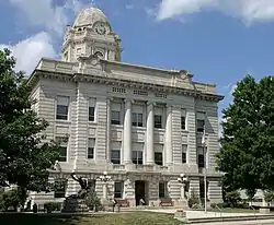 Jasper County Courthouse in Newton | |
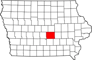 Location within the U.S. state of Iowa | |
 Iowa's location within the U.S. | |
| Coordinates: 41°41′17″N 93°03′41″W | |
| Country | |
| State | |
| Founded | 1846 |
| Named for | William Jasper |
| Seat | Newton |
| Largest city | Newton |
| Area | |
| • Total | 733 sq mi (1,900 km2) |
| • Land | 730 sq mi (1,900 km2) |
| • Water | 2.5 sq mi (6 km2) 0.3% |
| Population (2010) | |
| • Total | 36,842 |
| • Estimate (2018) | 37,147 |
| • Density | 50/sq mi (19/km2) |
| Time zone | UTC−6 (Central) |
| • Summer (DST) | UTC−5 (CDT) |
| Congressional district | 2nd |
| Website | www |
Jasper County is part of the Des Moines-West Des Moines, IA metropolitan area.[4]
Geography
According to the U.S. Census Bureau, the county has a total area of 733 square miles (1,900 km2), of which 730 square miles (1,900 km2) is land and 2.5 square miles (6.5 km2) (0.3%) is water.[5] The North and South Skunk River flow through the county. Bodies of water include Lake Mariposa and Rock Creek.
Major highways
Adjacent counties
- Marshall County (north)
- Poweshiek County (east)
- Mahaska County (southeast)
- Marion County (south)
- Polk County (west)
- Story County (northwest)
Demographics
| Historical population | |||
|---|---|---|---|
| Census | Pop. | %± | |
| 1850 | 1,280 | — | |
| 1860 | 9,883 | 672.1% | |
| 1870 | 22,116 | 123.8% | |
| 1880 | 25,963 | 17.4% | |
| 1890 | 24,943 | −3.9% | |
| 1900 | 26,976 | 8.2% | |
| 1910 | 27,034 | 0.2% | |
| 1920 | 27,855 | 3.0% | |
| 1930 | 32,936 | 18.2% | |
| 1940 | 31,496 | −4.4% | |
| 1950 | 32,305 | 2.6% | |
| 1960 | 35,282 | 9.2% | |
| 1970 | 35,425 | 0.4% | |
| 1980 | 36,425 | 2.8% | |
| 1990 | 34,795 | −4.5% | |
| 2000 | 37,213 | 6.9% | |
| 2010 | 36,842 | −1.0% | |
| 2018 (est.) | 37,147 | [6] | 0.8% |
| U.S. Decennial Census[7] 1790-1960[8] 1900-1990[9] 1990-2000[10] 2010-2018[1] | |||
2010 census
The 2010 census recorded a population of 36,842 in the county, with a population density of 50.4692/sq mi (19.4863/km2). There were 16,181 housing units, of which 14,806 were occupied.[11]
2000 census
As of the census[12] of 2000, there were 37,213 people, 14,689 households, and 10,267 families residing in the county. The population density was 51 people per square mile (20/km2). There were 15,659 housing units at an average density of 22 per square mile (8/km2). The racial makeup of the county was 97.58% White, 0.83% Black or African American, 0.22% Native American, 0.44% Asian, 0.05% Pacific Islander, 0.26% from other races, and 0.62% from two or more races. 1.01% of the population were Hispanic or Latino of any race.
There were 14,689 households, out of which 31.70% had children under the age of 18 living with them, 59.30% were married couples living together, 7.40% had a female householder with no husband present, and 30.10% were non-families. 26.10% of all households were made up of individuals, and 11.80% had someone living alone who was 65 years of age or older. The average household size was 2.42 and the average family size was 2.92.
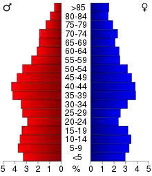
In the county, the population was spread out, with 24.60% under the age of 18, 7.40% from 18 to 24, 28.60% from 25 to 44, 23.40% from 45 to 64, and 16.00% who were 65 years of age or older. The median age was 38 years. For every 100 females there were 101.60 males. For every 100 females age 18 and over, there were 99.70 males.
The median income for a household in the county was $41,683, and the median income for a family was $50,071. Males had a median income of $36,001 versus $24,770 for females. The per capita income for the county was $19,622. About 4.80% of families and 6.50% of the population were below the poverty line, including 7.10% of those under age 18 and 7.00% of those age 65 or over.
Government and infrastructure
The Iowa Department of Corrections Newton Correctional Facility is in an unincorporated area in Jasper County, near Newton.[13]
| Year | Republican | Democratic | Third Parties |
|---|---|---|---|
| 2016 | 55.5% 10,560 | 37.4% 7,109 | 7.2% 1,365 |
| 2012 | 45.5% 8,877 | 52.6% 10,257 | 2.0% 381 |
| 2008 | 45.3% 8,794 | 52.8% 10,250 | 2.0% 378 |
| 2004 | 47.2% 9,462 | 52.0% 10,430 | 0.9% 170 |
| 2000 | 48.9% 8,729 | 48.8% 8,699 | 2.3% 407 |
| 1996 | 38.7% 6,414 | 52.9% 8,776 | 8.4% 1,395 |
| 1992 | 38.1% 6,866 | 45.1% 8,120 | 16.8% 3,026 |
| 1988 | 42.6% 6,703 | 56.8% 8,940 | 0.6% 90 |
| 1984 | 51.4% 8,576 | 48.0% 8,023 | 0.6% 100 |
| 1980 | 48.8% 8,286 | 42.8% 7,258 | 8.4% 1,422 |
| 1976 | 46.0% 7,728 | 52.3% 8,783 | 1.6% 275 |
| 1972 | 55.3% 9,133 | 42.4% 7,007 | 2.3% 373 |
| 1968 | 51.8% 7,901 | 43.0% 6,556 | 5.2% 798 |
| 1964 | 34.2% 5,321 | 65.7% 10,216 | 0.2% 24 |
| 1960 | 56.3% 9,332 | 43.7% 7,242 | 0.1% 11 |
| 1956 | 56.7% 9,310 | 43.2% 7,098 | 0.1% 20 |
| 1952 | 58.4% 9,610 | 41.0% 6,756 | 0.6% 99 |
| 1948 | 44.7% 5,710 | 52.3% 6,684 | 3.1% 392 |
| 1944 | 47.6% 6,413 | 51.8% 6,978 | 0.7% 88 |
| 1940 | 47.0% 7,240 | 52.7% 8,129 | 0.3% 52 |
| 1936 | 40.8% 5,875 | 57.8% 8,315 | 1.4% 205 |
| 1932 | 43.5% 5,399 | 54.7% 6,781 | 1.8% 221 |
| 1928 | 69.8% 9,144 | 29.4% 3,857 | 0.8% 107 |
| 1924 | 56.8% 6,565 | 10.5% 1,214 | 32.7% 3,778 |
| 1920 | 67.3% 7,417 | 30.7% 3,390 | 2.0% 222 |
| 1916 | 47.1% 3,092 | 50.0% 3,282 | 3.0% 194 |
| 1912 | 27.8% 1,766 | 39.2% 2,487 | 33.0% 2,092 |
| 1908 | 53.0% 3,543 | 43.2% 2,889 | 3.7% 249 |
| 1904 | 62.4% 3,962 | 30.6% 1,942 | 7.0% 446 |
| 1900 | 54.1% 3,894 | 44.0% 3,163 | 1.9% 136 |
| 1896 | 47.2% 2,768 | 51.5% 3,019 | 1.3% 76 |
Communities
Cities
Townships
Population ranking
The population ranking of the following table is based on the 2010 census of Jasper County.[15]
† county seat
| Rank | City/Town/etc. | Municipal type | Population (2010 Census) |
|---|---|---|---|
| 1 | † Newton | City | 15,254 |
| 2 | Mitchellville (mostly in Polk County) | City | 2,254 |
| 3 | Colfax | City | 2,093 |
| 4 | Monroe | City | 1,830 |
| 5 | Prairie City | City | 1,680 |
| 6 | Baxter | City | 1,101 |
| 7 | Sully | City | 821 |
| 8 | Kellogg | City | 599 |
| 9 | Lynnville | City | 379 |
| 10 | Mingo | City | 302 |
| 11 | Lambs Grove | City | 172 |
| 12 | Oakland Acres | City | 156 |
| 13 | Reasnor | City | 152 |
| 14 | Valeria | City | 57 |
Notable people
- John M. Haines, tenth Governor of Idaho; born in Jasper County.[16]
- Lyle Goodhue, chemist and inventor, born in Jasper County.
- Sara Haines, American television host and journalist.
References
- "State & County QuickFacts". United States Census Bureau. Archived from the original on June 7, 2011. Retrieved July 18, 2014.
- "Find a County". National Association of Counties. Archived from the original on May 31, 2011. Retrieved June 7, 2011.
- Weaver, James Baird (1912). Past and Present of Jasper County, Iowa, Volume 1. B.F. Bowen. p. 44.
- United States Office of Management and Budget. "Update of Statistical Area Definitions and Guidance on Their Uses" (PDF). pp. 5, 36. Archived from the original (PDF) on May 14, 2006. Retrieved July 21, 2006.
- "US Gazetteer files: 2010, 2000, and 1990". United States Census Bureau. February 12, 2011. Retrieved April 23, 2011.
- "Population and Housing Unit Estimates". Retrieved June 20, 2019.
- "U.S. Decennial Census". United States Census Bureau. Retrieved July 18, 2014.
- "Historical Census Browser". University of Virginia Library. Retrieved July 18, 2014.
- "Population of Counties by Decennial Census: 1900 to 1990". United States Census Bureau. Retrieved July 18, 2014.
- "Census 2000 PHC-T-4. Ranking Tables for Counties: 1990 and 2000" (PDF). United States Census Bureau. Retrieved July 18, 2014.
- "Population & Housing Occupancy Status 2010". United States Census Bureau American FactFinder. Retrieved May 18, 2011.
- "U.S. Census website". United States Census Bureau. Retrieved January 31, 2008.
- "Newton Correctional Facility Archived June 13, 2011, at the Wayback Machine." Iowa Department of Corrections. Retrieved on November 24, 2010. "Newton Correctional Facility 307 S. 60th Avenue W. P. O. Box 218 Newton, IA 50208"
- Leip, David. "Dave Leip's Atlas of U.S. Presidential Elections". uselectionatlas.org. Retrieved April 26, 2018.
- "2010 U.S. Census website". United States Census Bureau. Retrieved February 13, 2016.
- "Idaho Governor John Michiner Haines". National Governors Association. Retrieved September 19, 2012.
External links
| Wikimedia Commons has media related to Jasper County, Iowa. |
Places adjacent to Jasper County, Iowa | ||||||||||
|---|---|---|---|---|---|---|---|---|---|---|
| ||||||||||
Municipalities and communities of Jasper County, Iowa, United States | ||
|---|---|---|
| Cities | Map of Iowa highlighting Jasper County | |
| Townships | ||
| Unincorporated communities | ||
| Footnotes | ‡This populated place also has portions in an adjacent county or counties | |
| ||

| Authority control |
|---|