Muscatine County, Iowa
Muscatine County is a county located in the U.S. state of Iowa. As of the 2010 census, the population was 42,745.[1] The county seat is Muscatine.[2] The southeastern border is formed by the Mississippi River.
Muscatine County | |
|---|---|
 Muscatine County Courthouse in Muscatine | |
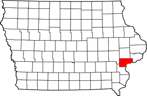 Location within the U.S. state of Iowa | |
 Iowa's location within the U.S. | |
| Coordinates: 41°28′52″N 91°07′11″W | |
| Country | |
| State | |
| Founded | December 7, 1836 |
| Named for | Mascouten tribe |
| Seat | Muscatine |
| Largest city | Muscatine |
| Area | |
| • Total | 449 sq mi (1,160 km2) |
| • Land | 437 sq mi (1,130 km2) |
| • Water | 12 sq mi (30 km2) 2.6% |
| Population (2010) | |
| • Total | 42,745 |
| • Estimate (2018) | 42,929 |
| • Density | 95/sq mi (37/km2) |
| Time zone | UTC−6 (Central) |
| • Summer (DST) | UTC−5 (CDT) |
| Congressional district | 2nd |
Muscatine County comprises the Muscatine, IA Micropolitan Statistical Area, which is included in the Davenport-Moline, IA-IL Combined Statistical Area.
History
Muscatine County was formed in December 1836 as a part of Wisconsin Territory, partitioned from Des Moines County, which had been organized two years previous.[3] One history suggests that the county was named for Muscatine Island in the Mississippi River. The island lies opposite Muscatine County and was believed to be named after the Mascouten tribe, Algonquian-speaking Native Americans who lived in the area before being driven west by settler encroachment and other tribes.[4]
Colonel George Davenport of Illinois sent three representatives into the territory in 1833 to establish a trade post. They were the first European Americans to settle there. In the same year, James W. Casey and John Vanatta came to the area. They opened a supply depot for steamboats on June 1, 1833, and named it Casey's Woodpile (since steamboats used wood as fuel). Muscatine County officially became a part of Iowa Territory on July 4, 1836, when Iowa Territory was established by partitioning off this area from Wisconsin Territory.[3] The first public land sale was held in November 1838. One year later, officials began construction of the first courthouse and associated jail. A second jail, known as the "Old Jail", was built in 1857.[5]
The first courthouse was destroyed by fire on December 23, 1864. By 1866 a new replacement stood at the same site. The present courthouse was built in the twentieth century, being first used on September 26, 1907.[6]
Geography
According to the US Census Bureau, the county has a total area of 449 square miles (1,160 km2), of which 437 square miles (1,130 km2) is land and 12 square miles (31 km2) (2.6%) is water.[7]
Adjacent counties
- Cedar County (north)
- Johnson County (northwest)
- Louisa County (south, southwest)
- Rock Island County, Illinois (east), across the Mississippi River
- Scott County (northeast)
Transportation
Major highways
 U.S. Route 6 – enters from Cedar County, west of Wilton, runs south two miles, then continues west and west-northwest to the northwest corner of the county, exiting into Johnson County.
 U.S. Route 61 – enters from Louisa County, southwest of Fruitland. Runs northeast through the county, passing Muscatine, before turning east to enter Scott County at Blue Grass.
 Iowa Highway 22 – begins at an intersection with Iowa 70, three miles east of Nichols. Runs east and southeast to an intersection with US 61, west of Muscatine.
 Iowa Highway 38 – begins at an intersection with US 6, three miles south of Wilton. Runs south to an intersection with US 61, north of Muscatine.
 Iowa Highway 70 – enters from Louisa County at the southwest corner of Muscatine County. Runs north, northeast and east to Cedar County, passing Nichols and West Liberty.
 Iowa Highway 92 - enters Muscatine County (and state of Iowa), running northwest across the historic Norbert F. Beckey Bridge into central Muscatine. Runs southwest along the Mississippi River to intersection with US 61, southwest of Muscatine.[8]
Other roadway designations
- Great River Road - system of roadways marking north–south routes across the conterminous US, and generally passing through Iowa.
County highways
- County Highway F58 (formerly Hwy 927)
- County Highway F62
- County Highway F65
- County Highway F70 (155th St)
- County Highway G14 (180th St)
- County Highway G28 (230th/231st Sts)
- County Highway G34 (275th St)
- County Highway G38 (Fruitland Rd)
- County Highway X34 (Davis Ave)
- County Highway X40 (Garfield Ave)
- County Highway X46 (Kelly Ave/170th St)
- County Highway X61 (Stewart Rd)
- County Highway Y14 (Taylor Ave)
- County Highway Y26 (Vail Ave)
- County Highway Y30 (Western Ave)
- County Highway Y36 (Zachary Ave)
Demographics
| Historical population | |||
|---|---|---|---|
| Census | Pop. | %± | |
| 1850 | 5,731 | — | |
| 1860 | 16,444 | 186.9% | |
| 1870 | 21,688 | 31.9% | |
| 1880 | 23,170 | 6.8% | |
| 1890 | 24,504 | 5.8% | |
| 1900 | 28,242 | 15.3% | |
| 1910 | 29,505 | 4.5% | |
| 1920 | 29,042 | −1.6% | |
| 1930 | 29,385 | 1.2% | |
| 1940 | 31,296 | 6.5% | |
| 1950 | 32,148 | 2.7% | |
| 1960 | 33,840 | 5.3% | |
| 1970 | 37,181 | 9.9% | |
| 1980 | 40,436 | 8.8% | |
| 1990 | 39,907 | −1.3% | |
| 2000 | 41,722 | 4.5% | |
| 2010 | 42,745 | 2.5% | |
| 2018 (est.) | 42,929 | [9] | 0.4% |
| U.S. Decennial Census[10] 1790-1960[11] 1900-1990[12] 1990-2000[13] 2010-2018[1] | |||
2010 census
The 2010 census recorded a population of 42,745 in the county, with a population density of 99.7154/sq mi (38.5003/km2). There were 17,910 housing units, of which 16,412 were occupied.[14]
2000 census
As of the census[15] of 2000, there were 41,722 people, 15,847 households, and 11,283 families residing in the county. The population density was 95 people per square mile (37/km2). There were 16,786 housing units at an average density of 38 per square mile (15/km2). The racial makeup of the county was 90.72% White, 0.70% Black or African American, 0.31% Native American, 0.83% Asian, 0.02% Pacific Islander, 6.05% from other races, and 1.37% from two or more races. 11.92% of the population were Hispanic or Latino of any race.
There were 15,847 households, out of which 34.80% had children under the age of 18 living with them, 57.90% were married couples living together, 9.30% had a female householder with no husband present, and 28.80% were non-families. 24.10% of all households were made up of individuals, and 9.90% had someone living alone who was 65 years of age or older. The average household size was 2.59 and the average family size was 3.07.
In the county, the population was spread out, with 26.90% under the age of 18, 8.60% from 18 to 24, 28.80% from 25 to 44, 22.80% from 45 to 64, and 12.90% who were 65 years of age or older. The median age was 36 years. For every 100 females, there were 98.10 males. For every 100 females age 18 and over, there were 94.90 males.
The median income for a household in the county was $41,803, and the median income for a family was $48,373. Males had a median income of $36,329 versus $24,793 for females. The per capita income for the county was $19,625. About 6.30% of families and 8.90% of the population were below the poverty line, including 10.70% of those under age 18 and 7.70% of those age 65 or over.
Communities
Cities
- Atalissa
- Blue Grass (part)
- Conesville
- Durant (part)
- Fruitland
- Muscatine
- Nichols
- Stockton
- Walcott (part)
- West Liberty
- Wilton
Unincorporated communities
Townships
Population ranking
The population ranking of the table is based on the 2010 census of Muscatine County.[16]
† county seat
| Rank | City/Town/etc. | Municipal type | Population (2010 Census) |
|---|---|---|---|
| 1 | † Muscatine | City | 22,886 |
| 2 | West Liberty | City | 3,736 |
| 3 | Wilton (partially in Cedar County) | City | 2,802 |
| 4 | Durant (mostly in Scott and Cedar Counties) | City | 1,832 |
| 5 | Walcott (partially in Scott County) | City | 1,629 |
| 6 | Blue Grass (mostly in Scott County) | City | 1,452 |
| 7 | Fruitland | City | 977 |
| 8 | Conesville | City | 432 |
| 9 | Nichols | City | 374 |
| 10 | Atalissa | City | 311 |
| 11 | Stockton | City | 197 |
Politics
| Year | Republican | Democratic | Third Parties |
|---|---|---|---|
| 2020 | 52.4% 10,823 | 45.3% 9,372 | 2.3% 476 |
| 2016 | 49.3% 9,584 | 43.1% 8,368 | 7.6% 1,482 |
| 2012 | 41.1% 8,168 | 57.0% 11,323 | 1.9% 374 |
| 2008 | 41.5% 7,929 | 57.1% 10,920 | 1.4% 271 |
| 2004 | 48.2% 9,020 | 51.0% 9,542 | 0.8% 155 |
| 2000 | 46.6% 7,483 | 50.1% 8,058 | 3.3% 535 |
| 1996 | 38.1% 5,858 | 49.9% 7,674 | 12.1% 1,854 |
| 1992 | 36.1% 6,087 | 42.0% 7,089 | 21.9% 3,688 |
| 1988 | 49.0% 6,904 | 50.1% 7,059 | 1.0% 139 |
| 1984 | 59.8% 9,069 | 39.5% 5,986 | 0.7% 113 |
| 1980 | 51.7% 7,829 | 37.0% 5,597 | 11.4% 1,719 |
| 1976 | 53.1% 7,697 | 45.3% 6,567 | 1.6% 232 |
| 1972 | 61.8% 8,436 | 36.0% 4,917 | 2.1% 289 |
| 1968 | 57.2% 7,361 | 36.7% 4,726 | 6.1% 787 |
| 1964 | 40.9% 5,547 | 59.1% 8,020 | 0.1% 10 |
| 1960 | 58.2% 8,555 | 41.7% 6,135 | 0.1% 8 |
| 1956 | 59.8% 8,552 | 40.0% 5,718 | 0.2% 28 |
| 1952 | 61.6% 9,361 | 38.0% 5,772 | 0.4% 63 |
| 1948 | 51.7% 6,003 | 47.1% 5,466 | 1.3% 146 |
| 1944 | 59.4% 7,104 | 40.1% 4,801 | 0.5% 58 |
| 1940 | 59.2% 8,543 | 40.4% 5,825 | 0.4% 53 |
| 1936 | 47.6% 6,332 | 49.5% 6,593 | 2.9% 388 |
| 1932 | 47.7% 6,160 | 49.7% 6,423 | 2.6% 334 |
| 1928 | 67.5% 8,604 | 31.8% 4,055 | 0.8% 98 |
| 1924 | 64.9% 7,731 | 16.5% 1,963 | 18.7% 2,223 |
| 1920 | 70.3% 8,115 | 19.9% 2,293 | 9.8% 1,136 |
| 1916 | 54.3% 3,929 | 37.2% 2,694 | 8.6% 619 |
| 1912 | 11.1% 789 | 37.7% 2,679 | 51.2% 3,642 |
| 1908 | 49.4% 3,525 | 42.6% 3,038 | 8.0% 568 |
| 1904 | 57.0% 4,036 | 36.1% 2,555 | 6.9% 485 |
| 1900 | 54.9% 3,905 | 42.5% 3,021 | 2.6% 184 |
| 1896 | 55.0% 3,627 | 43.4% 2,863 | 1.6% 102 |
References
- "State & County QuickFacts". United States Census Bureau. Archived from the original on June 7, 2011. Retrieved July 20, 2014.
- "Find a County". National Association of Counties. Retrieved June 7, 2011.
- "WI: Individual County Chronologies". publications.newberry.org. Retrieved September 28, 2016.
- History of Muscatine County Iowa - History Section, 1879, retrieved May 11, 2009
- "Local Sights". Muscatine County Sheriff. Archived from the original on February 8, 2012. Retrieved April 23, 2012.
- HistoryArchived July 28, 2012, at the Wayback Machine
- "US Gazetteer files: 2010, 2000, and 1990". US Census Bureau. February 12, 2011. Retrieved April 23, 2011.
- Muscatine County Google Maps (accessed 17 August 2018)
- "Population and Housing Unit Estimates". Retrieved June 19, 2019.
- "U.S. Decennial Census". United States Census Bureau. Retrieved July 20, 2014.
- "Historical Census Browser". University of Virginia Library. Retrieved July 20, 2014.
- "Population of Counties by Decennial Census: 1900 to 1990". US Census Bureau. Retrieved July 20, 2014.
- "Census 2000 PHC-T-4. Ranking Tables for Counties: 1990 and 2000" (PDF). US Census Bureau. Retrieved July 20, 2014.
- "Population & Housing Occupancy Status 2010". US Census Bureau – American FactFinder. Retrieved May 19, 2011.
- "U.S. Census website". US Census Bureau. Retrieved January 31, 2008.
- 2010 Census
- Leip, David. "Dave Leip's Atlas of U.S. Presidential Elections". uselectionatlas.org. Retrieved April 27, 2018.
External links
| Wikimedia Commons has media related to Muscatine County, Iowa. |
Places adjacent to Muscatine County, Iowa | ||||||||||
|---|---|---|---|---|---|---|---|---|---|---|
| ||||||||||
Municipalities and communities of Muscatine County, Iowa, United States | ||
|---|---|---|
| Cities | Map of Iowa highlighting Muscatine County | |
| Townships | ||
| Unincorporated communities | ||
| Footnotes | ‡This populated place also has portions in an adjacent county or counties | |
| ||

| Authority control |
|---|