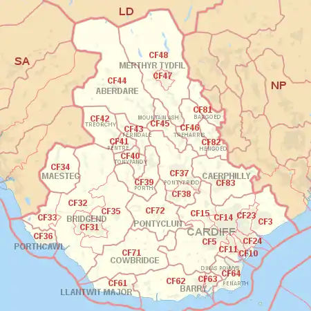
CF postcode area
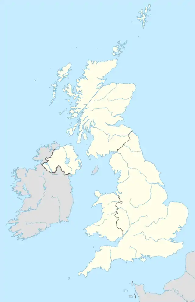
The CF postcode area, also known as the Cardiff postcode area,[2] is a group of 35 postcode districts for post towns: Cardiff, Bridgend, Merthyr Tydfil, Caerphilly, Aberdare, Bargoed, Barry, Cowbridge, Dinas Powys, Ferndale, Hengoed, Llantwit Major, Maesteg, Mountain Ash, Penarth, Pentre, Pontyclun, Pontypridd, Porth, Porthcawl, Rhoose, Sully, Tonypandy, Treharris and Treorchy in south Wales.
Cardiff | |
|---|---|
 CF | |
| Coordinates: 51.552°N 3.327°W | |
| Country | United Kingdom |
| Postcode area | CF |
| Postcode area name | Cardiff |
| Post towns | 23 |
| Postcode districts | 46 |
| Postcode sectors | 203 |
| Postcodes (live) | 23,163 |
| Postcodes (total) | 42,309 |
| Statistics as at May 2020[1] | |
Coverage
The approximate coverage of the postcode districts:
|-
! CF3
| CARDIFF
| CARDIFF SOUTH (East):
Rumney & Trowbridge, Llanrumney, St Mellons
NEWPORT WEST:
Castleton, Marshfield
| Cardiff, Newport
|-
! CF5
| CARDIFF
| CARDIFF WEST (South):
Ely, Caerau, St Fagans, Culverhouse Cross, Canton & Leckwith, Fairwater, Danescourt, Llandaff, Riverside
VALE OF GLAMORGAN:
Wenvoe, Peterston Super Ely, St Georges super Ely, Michaelston-le-Pit, Michaelston-super-Ely
| Cardiff, Vale of Glamorgan
|-
! CF10
| CARDIFF
| CARDIFF CENTRAL / CARDIFF SOUTH:
CARDIFF CITY CENTRE (part of), Grangetown, CARDIFF BAY (part of) & Butetown
| Cardiff
|-
! CF11
| CARDIFF
| CARDIFF CENTRAL / CARDIFF SOUTH:
CARDIFF CITY CENTRE (part of), Canton, CARDIFF BAY (part of), Grangetown
| Cardiff
|-
! CF14
| CARDIFF
| CARDIFF NORTH (West):
Birchgrove, Whitchurch, Thornhill & Lisvane, Rhiwbina & Pantmawr, Gabalfa, Heath, Llandaff North, Llanishen
| Cardiff
|-
! CF15
| CARDIFF
| CARDIFF WEST (North):
Pentyrch & Gwaelod-y-Garth & Creigiau, Radyr & Morganstown, Tongwynlais
RHONDDA CYNON TAFF:
Taffs Well & Nantgarw
CAERPHILLY:
Groeswen
| Cardiff, Rhondda Cynon Taf, Caerphilly
|-
! CF23
| CARDIFF
| CARDIFF NORTH (East):
Llanishen, Cyncoed, Pentwyn, Penylan, Pontprennau & Old St Mellons
| Cardiff
|-
! CF24
| CARDIFF
| CARDIFF CENTRAL:
CARDIFF CITY CENTRE (part of) & Cathays, Roath & Plasnewydd, Splott, Adamsdown
| Cardiff
|-
! style="background:#FFFFFF;"|CF30
| style="background:#FFFFFF;"|CARDIFF
| style="background:#FFFFFF;"|
| style="background:#FFFFFF;"|non-geographic
|-
! CF31
| BRIDGEND
| Bridgend, Brackla, Coity, Pen-y-fai
| Bridgend
|-
! CF32
| BRIDGEND
| BRIDGEND:
Cefn Cribwr, Laleston, Merthyr Mawr, Ogmore Vale, Tondu, Sarn, Ynysawdre, St Bride's Minor, Pontycymer, Llangeinor, Garw Valley, Blaengarw, Blackmill, Bettws, Aberkenfig
VALE OF GLAMORGAN:
St Brides Major
| Bridgend, Vale of Glamorgan
|-
! CF33
| BRIDGEND
| Cornelly, Pyle
| Bridgend
|-
! CF34
| MAESTEG
| Maesteg, Llangynwyd, Caerau, Nantyffyllon
| Bridgend
|-
! CF35
| BRIDGEND
| BRIDGEND:
PENCOED TOWN, Coychurch, Llangan
VALE OF GLAMORGAN:
Ewenny
| Bridgend, Vale of Glamorgan
|-
! CF36
| PORTHCAWL
| Porthcawl, Nottage, Newton
| Bridgend
|-
! CF37
| PONTYPRIDD
| Pontypridd Community:
PONTYPRIDD TOWN including Cilfynydd, Glyncoch, Graig, Treforest, Hopkinstown, Trallwng, Maesycoed, Pwllgwaun, Hawthorn, Rhydfelen, TREHAFOD
Ynysybwl Community:
YNYSYBWL & Coed-y-Cwm
| Rhondda Cynon Taf
|-
! CF38
| PONTYPRIDD
| Llantwit Fardre Community:
LLANTWIT FARDRE, CHURCH VILLAGE, Tonteg, Efail Isaf
Llantrisant Community (part of):
BEDDAU & Ty Nant
| Rhondda Cynon Taf
|-
! CF39
| PORTH
| Rhondda Area (RCT):
PORTH TOWN & Llwyncelyn, CYMMER & Glynfach & Trebanog, YNYSHIR & Wattstown, Dinas (part of)
Taff-Ely Area (RCT):
TONYREFAIL TOWN & Coed-Ely & Thomastown, GILFACH GOCH
BRIDGEND:
Evanstown
| Rhondda Cynon Taf, Bridgend
|-
! CF40
| TONYPANDY
| Rhondda Area:
TONYPANDY TOWN, TREALAW, PENYGRAIG, Dinas (part of), Williamstown, Cwm Clydach, LLWYNYPIA
Taff-Ely Area:
Penrhiwfer
| Rhondda Cynon Taf
|-
! CF41
| PENTRE
| Pentre, Ton Pentre, Ystrad, Gelli
| Rhondda Cynon Taf
|-
! CF42
| TREORCHY
| Treorchy, Cwmparc, Ynyswen, Treherbert, Blaencwm, Blaenrhondda
| Rhondda Cynon Taf
|-
! CF43
| FERNDALE
| Ferndale, Blaenllechau, Tylorstown, Penrhys, Pontygwaith, Stanleytown, Maerdy
| Rhondda Cynon Taf
|-
! CF44
| ABERDARE
| Aberdare, Cwmaman, Aberaman, Llwydcoed, Cwmbach, Hirwaun, Penywaun, Rhigos, Penderyn
| Rhondda Cynon Taf
|-
! CF45
| MOUNTAIN ASH
| Mountain Ash, Abercynon, Penrhiwceiber, Ynysboeth
| Rhondda Cynon Taf
|-
! CF46
| TREHARRIS
| Treharris, Quakers Yard, Bedlinog, Nelson
| Merthyr Tydfil, Caerphilly
|-
! CF47
| MERTHYR TYDFIL
| Merthyr Tydfil, Gurnos, Penydarren
| Merthyr Tydfil
|-
! CF48
| MERTHYR TYDFIL
| Cyfarthfa, Pant, Merthyr Vale, Troed-y-rhiw, Vaynor, Pentrebach
| Merthyr Tydfil
|-
! CF61
| LLANTWIT MAJOR
| Llantwit Major, Llan-maes
| Vale of Glamorgan
|-
! CF62
| BARRY
| Barry (west), Rhoose, St Athan, Llancarfan, Barry Island
| Vale of Glamorgan
|-
! CF63
| BARRY
| Barry (east), Cadoxton, Barry Docks
| Vale of Glamorgan
|-
! CF64
| PENARTH; DINAS POWYS
| Penarth, Dinas Powys, Sully, Llandough
| Vale of Glamorgan
|-
! CF71
| COWBRIDGE
| Cowbridge, St Brides Major, Welsh St Donats, Pendoylan, Llandow, Colwinston, Llanblethian, Penllyn, Llanfair
| Vale of Glamorgan
|-
! CF72
| PONTYCLUN
| Pontyclun, Llantrisant, Llanharan, Talbot Green, Brynsadler, Miskin, Brynna, Llanharry
| Rhondda Cynon Taf
|-
! CF81
| BARGOED
| Bargoed, Aberbargoed, Darran Valley, Gilfach, Pontlottyn
| Caerphilly
|-
! CF82
| HENGOED
| Hengoed, Cefn Hengoed, Ystrad Mynach, Gelligaer, Maesycwmmer
| Caerphilly
|-
! CF83
| CAERPHILLY
| Caerphilly, Abertridwr, Senghenydd, Bedwas, Trethomas, Machen, Llanbradach, Pwllypant, Penyrheol, Energlyn, Trecenydd, Rudry
| Caerphilly
|-
! style="background:#FFFFFF;"|CF91
| style="background:#FFFFFF;"|CARDIFF
| style="background:#FFFFFF;"|
| style="background:#FFFFFF;"|non-geographic
|-
! style="background:#FFFFFF;"|CF95
| style="background:#FFFFFF;"|CARDIFF
| style="background:#FFFFFF;"|
| style="background:#FFFFFF;"|non-geographic
|-
! style="background:#FFFFFF;"|CF99
| style="background:#FFFFFF;"|CARDIFF
| style="background:#FFFFFF;"|
| style="background:#FFFFFF;"|non-geographic
|}
Map
References
- "ONS Postcode Directory Version Notes" (ZIP). National Statistics Postcode Products. Office for National Statistics. May 2020. Table 2. Retrieved 19 June 2020. Coordinates from mean of unit postcode points, "Code-Point Open". OS OpenData. Ordnance Survey. February 2012. Retrieved 21 April 2012.
- Royal Mail, Address Management Guide, (2004)