West Isles Parish, New Brunswick
West Isles is a civil parish in Charlotte County, New Brunswick, Canada,[3] comprising a single local service district (LSD), which is a member of the Southwest New Brunswick Service Commission (SNBSC).[4]
West Isles
Deer Island | |
|---|---|
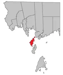 Location within Charlotte County. | |
| Country | |
| Province | |
| County | Charlotte County |
| Erected | 1786 |
| Area | |
| • Land | 38.35 km2 (14.81 sq mi) |
| Population (2016)[2] | |
| • Total | 797 |
| • Density | 20.8/km2 (54/sq mi) |
| • Pop 2011-2016 | |
| • Dwellings | 467 |
| Time zone | UTC-4 (AST) |
| • Summer (DST) | UTC-3 (ADT) |
The parish contains dozens of offshore islands but only the largest, Deer Island, is inhabited. There are no bridges and only Deer Island has ferry service.
History
West Isles was erected in 1786 as one of the original parishes of the county,[6] specifically including Deer Island, Campobello, and Grand Manan, as well as several islands in Cobscook Bay.
In 1803 Campobello was erected as its own parish, including nearby minor islands.[7]
In 1816 Grand Manan and was erected as its own parish, including nearby minor islands.[8]
In 1817 commissioners appointed under the Treaty of Ghent settled the boundary dispute in the islands off Charlotte County, awarding the islands in Cobscook Bay to the United States.
In 1877 the boundary with Campobello Parish was clarified as running through Head Harbour Passage; the boundary with Saint George Parish was specified as running through Letete Passage rather than two miles from the mainland.[9]
Boundaries
West Isles Parish comprises "Deer Island and any contiguous islands not in one of the parishes neighbouring it. It's separated from Saint George by Letete Passage, from Campobello by Head Harbour Passage, and from Maine by Western Passage."[3]
Local service district
The local service district of the parish of West Isles comprises the entire parish.[10]
The LSD was established in 1970 to assess for fire protection.[11] First aid and ambulance services were added in 1982,[12] recreational facilities in 1987.[13]
Today the LSD assesses community & recreation services as well as the basic LSD services of fire protection, police services, land use planning, emergency measures, and dog control.[14] The taxing authority is 517.00 West Isles.
Demographics
Population
| Canada census – West Isles Parish, New Brunswick community profile | |||
|---|---|---|---|
| 2016 | 2011 | 2006 | |
| Population: | 797 (+9.0% from 2011) | 731 (-11.3% from 2006) | 824 (-3.2% from 2001) |
| Land area: | 38.35 km2 (14.81 sq mi) | 38.01 km2 (14.68 sq mi) | 37.93 km2 (14.64 sq mi) |
| Population density: | 20.8/km2 (54/sq mi) | 19.2/km2 (50/sq mi) | 21.7/km2 (56/sq mi) |
| Median age: | 48.4 (M: 49.0, F: 46.8) | 47.5 (M: 46.5, F: 48.4) | 43.6 (M: 42.4, F: 44.9) |
| Total private dwellings: | 467 | 485 | 499 |
| Median household income: | $56,736 | $.N/A | $40,640 |
| Notes: 2011 income data for this area has been suppressed for data quality or confidentiality reasons. – References: 2016[15] 2011[16] 2006[17] earlier[18] | |||
|
|
| |||||||||||||||||||||||||||
| [19][2][1] | |||||||||||||||||||||||||||||
Language
| Canada Census Mother Tongue - West Isles Parish, New Brunswick[19] | ||||||||||||||||||
|---|---|---|---|---|---|---|---|---|---|---|---|---|---|---|---|---|---|---|
| Census | Total | English |
French |
English & French |
Other | |||||||||||||
| Year | Responses | Count | Trend | Pop % | Count | Trend | Pop % | Count | Trend | Pop % | Count | Trend | Pop % | |||||
2011 |
730 |
710 | 97.26% | 15 | 2.05% | 5 | 0.69% | 0 | 0.00% | |||||||||
2006 |
820 |
820 | 100.00% | 0 | 0.00% | 0 | 0.00% | 0 | 0.00% | |||||||||
2001 |
850 |
830 | 97.65% | 10 | 1.18% | 0 | 0.00% | 10 | 1.18% | |||||||||
1996 |
850 |
850 | n/a | 100.00% | 0 | n/a | 0.00% | 0 | n/a | 0.00% | 0 | n/a | 0.00% | |||||
Communities
Communities within the parish;[20][21][22] italics indicate a deprecated name.
|
|
|
Bodies of water
Bodies of water at least partly within the parish;[20][21][22] * indicates a freshwater body; italics indicates a deprecated name.[lower-alpha 1]
|
|
|
|
Islands
Islands within the parish;[20][21][22] italics indicate a deprecated name.[lower-alpha 1]
|
|
|
|
Conservation areas
Conservation areas within the parish.
- Whitehorse Island Protected Natural Area[23][lower-alpha 4]
Access Routes
Highways and numbered routes that run through the parish, including external routes that start or finish at the parish limits:[24]
|
|
|
|
See also
Notes
- Categorised as Historical rather than Official by the Canadian Geographic Name Service; only those significantly different are noted.
- A small bay.
- A tidal flow between islands.
- On White Horse Island; it's not unknown for government departments to use difference spellings for the same place.
References
- "Census Profile, 2016 Census: West Isles, Parish [Census subdivision], New Brunswick". Statistics Canada. Retrieved September 7, 2019.
- "West Isles, New Brunswick (Code 1302006) and Charlotte, New Brunswick (Code 1302) (table)". 2011 Census of Population. Statistics Canada. Retrieved July 16, 2012.
- "Chapter T-3 Territorial Division Act". Government of New Brunswick. Retrieved 1 August 2020.
- "Communities in each of the 12 Regional Service Commissions (RSC) / Les communautés dans chacune des 12 Commissions de services régionaux (CSR)" (PDF), Government of New Brunswick, July 2017, retrieved 1 February 2021
- Ganong, William F. (1896). A Monograph of the Place-Nomenclature of the Province of New Brunswick. Royal Society of Canada. p. 279.
- "26 Geo. III Chapter I. An Act for the better ascertaining and confirming the Boundaries of the several Counties within this Province, and for subdividing them into Towns or Parishes.". Acts of the General Assembly of His Majesty's Province of New-Brunswick, passed in the year 1786. Saint John, New Brunswick: Government of New Brunswick. 1786. pp. 3–12.
- "43 Geo. III c. 4 An Act, in addition to an Act, intitled "an Act for the better ascertaining and confirming the Boundaries of the several Counties within this Province, and for subdividing them into Towns and Parishes."". Acts of the General Assembly of His Majesty's Province of New-Brunswick. Passed in the Year 1803. Saint John, New Brunswick: Government of New Brunswick. 1803. p. 479.
- "56 Geo. III c. 10 An Act to constitute the Island of Grand-Manan and its appurtenances in the County of Charlotte into a distinct Town or Parish.". Acts of the General Assembly of His Majesty's Province of New-Brunswick. Passed in the Year 1816. Fredericton: Government of New Brunswick. 1816. p. 28.
- "Chapter 2 The Division of the Province into Counties, Towns, and Parishes.". The Consolidated Statutes of New Brunswick. Fredericton: Government of New Brunswick. 1877. pp. 56–85.
- "New Brunswick Regulation 84-168 under the Municipalities Act (O.C. 84-582)". Government of New Brunswick. Retrieved 6 February 2021.
- "Regulation 70–63 under the Municipalities Act (O. C. 70–385)". The Royal Gazette. Fredericton. 128: 343–344. 17 June 1970.
- New Brunswick Regulation 82-138. These were erroneously removed in Regulation 84-168, which rewrote the entire province, then restored in Regulation 86-8.
- New Brunswick Regulation 87-42.
- "2020 Local Government Statistics for New Brunswick" (PDF). Department of Environment and Local Government. p. 55. Retrieved 6 February 2021.
- "2016 Community Profiles". 2016 Canadian Census. Statistics Canada. February 21, 2017. Retrieved 2019-09-07.
- "2011 Community Profiles". 2011 Canadian Census. Statistics Canada. July 5, 2013. Retrieved 2014-03-19.
- "2006 Community Profiles". 2006 Canadian Census. Statistics Canada. March 30, 2011. Retrieved 2014-03-19.
- "2001 Community Profiles". 2001 Canadian Census. Statistics Canada. February 17, 2012.
- Statistics Canada: 1996, 2001, 2006, 2011 census
- "untitled spreadsheet of New Brunswick place names". Geographical names in Canada. Natural Resources Canada. Retrieved 20 July 2020.
- "No. 166". Provincial Archives of New Brunswick. Department of Natural Resources and Energy Development. Retrieved 27 September 2020.
- Official place names of New Brunswick checked against the cadastral map of the area.
- "Schedule I-3" (PDF). Natural Resources and Crown Lands. Government of New Brunswick. Retrieved 27 September 2020.
- Atlantic Canada Back Road Atlas ISBN 978-1-55368-618-7 Pages 4, 12
Places adjacent to West Isles Parish, New Brunswick | |
|---|---|
| Subdivisions | |
|---|---|
| Cities | |
| Counties | |
| |