Campobello Island
Campobello Island (/ˌkæmpəˈbɛloʊ/,[2][3] also US: /-poʊˈ-/)[4] is the largest and only inhabited island in Campobello, a civil parish in southwestern New Brunswick,[5] near the border with Maine.[6] The island's permanent population in 2016 was 872.[7] It is the site of the Roosevelt Campobello International Park and of Herring Cove Provincial Park.
Campobello Island
Île Campobello | |
|---|---|
Rural Community | |
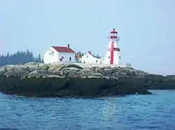 Head Harbour Light Station, Passamaquoddy Bay | |
 Campobello Island Location of Campobello Island in Canada 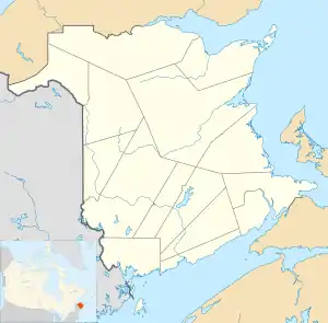 Campobello Island Campobello Island (New Brunswick) | |
| Coordinates: 44°53′N 66°56′W | |
| Country | |
| Province | |
| County | Charlotte County |
| Erected | 1803 |
| Area | |
| • Land | 39.67 km2 (15.32 sq mi) |
| Highest elevation | 90 m (300 ft) |
| Lowest elevation | 0 m (0 ft) |
| Population (2016) | |
| • Total | 872 |
| • Density | 22.0/km2 (57/sq mi) |
| • Pop 2011-2016 | |
| • Pop 2011-2016 density | 22/km2 (60/sq mi) |
| • Dwellings | 616 |
| Time zone | UTC-4 (AST) |
| • Summer (DST) | UTC-3 (ADT) |
It has been governed as an incorporated rural community since 2010 but still receives some local service district services from the province, being assessed for fire protection, policing, dog control, and general government,[8] and is a member of the Southwest New Brunswick Service Commission (SNBSC).[9] Despite the name, the rural community also includes all other islands in the parish.
The island is part of Charlotte County, which was formed in 1784 when New Brunswick was partitioned from Nova Scotia.[10] Campobello Parish was part of West Isles Parish until 1803, when it was erected as a separate parish. Campobello was claimed by the United States until the boundary in Passamaquoddy Bay was settled by commission in 1817.[11]
History
The island was originally settled by the Passamaquoddy Nation, who called it Ebaghuit.
The first Europeans were from the French expedition of Pierre Dugua de Mons and Samuel de Champlain, who founded the nearby Saint Croix Island settlement in 1604. France named the island Port aux Coquilles ("Seashell Harbour").
Following the War of the Spanish Succession, under terms of the Treaty of Utrecht (1713), the island became part of the British colony of Nova Scotia.
The population was increased by United Empire Loyalists after the American Revolutionary War. Smuggling was a major part of the island's prosperity around this time. During the War of 1812 the Royal Navy seized coastal lands of Maine as far south as the Penobscot River but returned them following the war, except for offshore islands. In 1817, the United States relinquished its claim to Campobello, Deer, and Grand Manan islands, in exchange for islands in Cobscook Bay.
In 1803 the island and small islands adjacent to it were separated from West Isles Parish to form their own parish called Campo-Bello.[12] The name appeared in government acts as Campo Bello in 1850, 1854, 1877, and 1896, finally appearing as Campobello in 1903.[13]
In 1866, a band of more than 700 members of the Fenian Brotherhood arrived at the Maine shore opposite the island with the intention of seizing Campobello[14] but were dispersed by British warships from Halifax.[15]
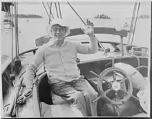
British naval officer John James Robinson became owner of the island in 1857. In 1881 it was sold to a group of American businessmen, including James Roosevelt. In the 1880s the island was developed as a resort summer colony for wealthy Canadians and Americans, as was nearby St. Andrews, New Brunswick and Bar Harbor, Maine. A luxurious resort hotel and many grand estates were built.[16] From 1883, the Roosevelt family made Campobello Island their summer home.
By the mid-1800s, Campobello Island had a population in excess of 1,000, which grew to 1,230 by 1910.
Origin of name
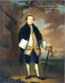
In 1770 the entire island was granted to Capt. William Owen, who understated the size of the island to circumvent the size limit on land grants at the time. Owen renamed the island Campobello in punning honour of Lord William Campbell,[17] who was Governor of Nova Scotia at the time. Campobello Parish later took its name from the island.
Geography
The island is at the entrance to Passamaquoddy Bay, adjacent to the entrance to Cobscook Bay, and within the Bay of Fundy. The island is one of the Fundy Islands. The island has no road connection to the rest of Canada; it is connected by the Franklin Delano Roosevelt Bridge to nearby Lubec, Maine. Reaching mainland Canada by car without crossing an international border is possible only during the summer season and requires two separate ferry trips, first to nearby Deer Island, then to L'Etete.[18] The ferry to Deer Island stopped in 2017, leaving the island without a direct connection to the rest of Canada.[19]
The jurisdiction of the eponymous rural community and of the census division include Head Harbour Island.
Measuring 14 kilometres (8.7 mi) long and about five kilometres (3.1 mi) wide, it has an area of 39.6 square kilometres (15.3 sq mi). On the north is a high bluff headland, East Quoddy Point.[20] On the west are Charley Point and the Mulholland Point navigation light.[20]
Economy
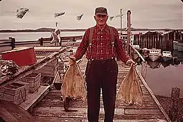
The island has several good harbours,[21] and the majority of residents are employed in the fishing, aquaculture or tourism industries.
The two major tourist attractions on the island are Herring Cove Provincial Park and Roosevelt Campobello International Park. The latter was created in 1964 and was officially opened by U.S. President Lyndon Johnson and Canadian Prime Minister Lester Pearson in 1966.
Infrastructure
The island's only highway, Route 774, is connected by the Franklin Delano Roosevelt Bridge to Lubec, Maine – the easternmost town in the continental United States. The only transportation link with the rest of Canada is a seasonal ferry service to Deer Island Point, New Brunswick, on Deer Island.[22]
Mail delivered to the community goes through the United States. The United States Customs and Border Protection service began searching packages to/from the island in 2019, prompting outcry from residents, and debates in the House of Commons of Canada, due to privacy and sovereignty concerns.[23][24][25]
In late 2020, residents renewed their demands for the Canadian government to build a bridge to the New Brunswick mainland because the current ferry boat cannot operate in winter. (Three other New Brunswick islands do benefit from year-round ferry service.) Driving to other points in Canada required travel into Maine via the bridge, difficult during the restrictions imposed on both sides of the border during the COVID-19 pandemic in North America. The border closure was particularly problematic, since it prohibited driving to and from the island, except for essential purposes.[26]
The government agreed to pay for an extension of the ferry service until 10 January 2021 but, afterwards, winter weather would make sailing the small ferry too dangerous. Islanders interviewed by the Toronto Star said that the restrictions were also causing serious problems for services attempting to reach the island, but insisted that the need for a bridge, or year-round ferry service, was long-standing and not just relevant during the pandemic. One of the residents made this comment: "You have to live there to see how bad it is when you don’t have a road to your own country". In an interview, Member of Parliament for the region, John Williamson, made no promises but offered a glimmer of hope: "I think we’re in a position that some infrastructure dollars could be made available once the province has a plan and proposal ready to submit".[27][28]
Education
The island has one school, Campobello Island Consolidated School, for all school grades, in the Anglophone South School District.
Census data
Population
| Canada census – Campobello Island community profile | |||
|---|---|---|---|
| 2016 | 2011 | 2006 | |
| Population: | 872 (-5.7% from 2011) | 925 (-12.4% from 2006) | 1,056 (-11.6% from 2001) |
| Land area: | 39.67 km2 (15.32 sq mi) | 39.67 km2 (15.32 sq mi) | 39.59 km2 (15.29 sq mi) |
| Population density: | 22.0/km2 (57/sq mi) | 23.3/km2 (60/sq mi) | 26.7/km2 (69/sq mi) |
| Median age: | 48.4 (M: 48.2, F: 48.4) | 46.0 (M: 46.1, F: 45.9) | 43.4 (M: 43.3, F: 43.5) |
| Total private dwellings: | 616 | 641 | 632 |
| Median household income: | $52,139 | $38,159 | |
| References: 2016[29] 2011[30] 2006[31] earlier[32] | |||
|
|
| |||||||||||||||||||||||||||
| [33][1] | |||||||||||||||||||||||||||||
Language
| Canada Census Mother Tongue - Campobello Parish, New Brunswick[33] | ||||||||||||||||||
|---|---|---|---|---|---|---|---|---|---|---|---|---|---|---|---|---|---|---|
| Census | Total | English |
French |
English & French |
Other | |||||||||||||
| Year | Responses | Count | Trend | Pop % | Count | Trend | Pop % | Count | Trend | Pop % | Count | Trend | Pop % | |||||
2011 |
895 |
885 | 98.88% | 5 | 0.56% | 0 | 0.00% | 5 | 0.56% | |||||||||
2006 |
1,035 |
985 | 95.17% | 30 | 2.90% | 0 | 0.00% | 20 | 1.93% | |||||||||
2001 |
1,165 |
1,165 | 100.00% | 0 | 0.00% | 0 | 0.00% | 0 | 0.00% | |||||||||
1996 |
1,280 |
1,280 | n/a | 100.00% | 0 | n/a | 0.00% | 0 | n/a | 0.00% | 0 | n/a | 0.00% | |||||
Communities
Communities within the rural community.[34][35][36]
- North Road
- Otter Cove
- Welshpool
- Wilsons Beach
Bodies of water
Bodies of water at least partly within the rural community.[34][35][36] * indicates a freshwater body.
|
|
|
|
Other islands
Other named islands within the rural community.[34][35][36]
- Duck Islands
- Head Harbour Island
- Little Island
References
- "Census Profile, 2016 Census: Campobello Island, Rural community [Census subdivision]". Statistics Canada. Retrieved 26 August 2019.
- "Campobello Island". Lexico UK Dictionary. Oxford University Press. Retrieved 28 July 2019.
- "Campobello". Merriam-Webster Dictionary. Retrieved 28 July 2019.
- "Campobello". Collins English Dictionary. HarperCollins. Retrieved 28 July 2019.
- "New Brunswick Regulation 84-168 under the Municipalities Act (O.C. 84-582)". Government of New Brunswick. Retrieved 1 August 2020.
- Community Profile: Campobello Parish, Charlotte County, New Brunswick; Statistics Canada.
- "Census Profile, 2016 Census: Campobello Island". Statistics Canada. Retrieved 10 August 2019.
- "2019 Local Government Statistics for New Brunswick" (PDF). Department of Environment and Local Government. p. 65. Retrieved 1 August 2020.
- "Communities in each of the 12 Regional Service Commissions (RSC) / Les communautés dans chacune des 12 Commissions de services régionaux (CSR)" (PDF), Government of New Brunswick, July 2017, retrieved 1 February 2021
- Slumkoski, Corey (2005). "The Partition of Nova Scotia". The Winslow Papers. Electronic text centre (UNB Libraries). Retrieved 5 May 2020.
- Edwards, M.J. (Ed.) (July 2013). Grand Manan & the War of 1812 (PDF). Grand Manan Museum. p. 14. Retrieved 24 June 2020.CS1 maint: extra text: authors list (link)
- "43 Geo. III c. 4 An Act, in addition to an Act, intitled "an Act for the better ascertaining and confirming the Boundaries of the several Counties within this Province, and for subdividing them into Towns and Parishes."". Acts of the General Assembly of His Majesty's Province of New-Brunswick. Passed in the Year 1803. Saint John, New Brunswick: Government of New Brunswick. 1803. p. 479.
- "Chapter 2. Respecting the Division of the Province into Counties, Towns, and Parishes.". The Consolidated Statutes of New Brunswick, 1903. Vol. I. Fredericton: Government of New Brunswick. 1903. pp. 17–54.
- Jennifer Crump (26 July 2010). Canada Under Attack. Dundurn. p. 133. ISBN 9781459704879.
- Buescher, John. "What Happened to the Fenians After 1866?" Teachinghistory.org, accessed 8 October 2011
- Erika J. Waters (2010). Kittery to Bar Harbor: Touring Coastal Maine. Arcadia Publishing. p. 119. ISBN 9780738572819.
- Ganong, William F. (1896). A Monograph of the Place-Nomenclature of the Province of New Brunswick. Royal Society of Canada. p. 224.
- Paul Karr (18 March 2005). Frommer'sMaine Coast. John Wiley & Sons. p. 248. ISBN 9780764595974.
- O'Connor, Joe (23 January 2018). "The island Canada forgot: On Campobello, citizens are left exiles in their own land". Financial Post. Retrieved 24 January 2019.
- U.S. Coast and Geodetic Survey (1879). Atlantic Local Coast Pilot: Sub-division 1: Passamaquoddy Bay to Schoodic. U.S. Government Printing Office. p. 15.
- Richardson Clover (1891). Sailing Directions for Nova Scotia, Bay of Fundy, and South Shore of Gulf of St. Lawrence. U.S. Government Printing Office. p. 29.
- David Goss (2002). St. George and Its Neighbours. Arcadia Publishing. p. 91. ISBN 9780738511498.
- "Canadian islanders angry over US mail searches". BBC. Retrieved 1 December 2019.
- "On quiet Campobello Island, Canadians angered by US inspection of their mail". Boston Globe. Retrieved 20 January 2020.
- "Cut off by geography and COVID-19, this Canadian island is calling out for a link to the rest of Canada — to no avail". Toronto Star. 3 January 2021. Retrieved 3 January 2021.
- "Canada extends restrictions on U.S. travellers until January 21". Toronto Star. 21 December 2020. Retrieved 3 January 2021.
The historic border closure between Canada and the U.S. will extend into the new year.
- "Campobello ferry service extended to January". CBC News. 11 December 2020. Retrieved 3 January 2021.
The ferry, privately owned ... typically runs from late June to September. It connects Campobello Island to Deer Island, where people can take a year-round ferry to mainland New Brunswick.
- "Cut off by geography and COVID-19, this Canadian island is calling out for a link to the rest of Canada — to no avail". Toronto Star. 3 January 2021. Retrieved 3 January 2021.
- "2016 Community Profiles". 2016 Canadian Census. Statistics Canada. 21 February 2017. Retrieved 26 August 2019.
- "2011 Community Profiles". 2011 Canadian Census. Statistics Canada. 5 July 2013. Retrieved 15 March 2014.
- "2006 Community Profiles". 2006 Canadian Census. Statistics Canada. 30 March 2011. Retrieved 15 March 2014.
- "2001 Community Profiles". 2001 Canadian Census. Statistics Canada. 17 February 2012.
- Statistics Canada: 1996, 2001, 2006, 2011 census
- "untitled spreadsheet of New Brunswick place names". Geographical names in Canada. Natural Resources Canada. Retrieved 20 July 2020.
- "No. 166". Provincial Archives of New Brunswick. Department of Natural Resources and Energy Development. Retrieved 27 September 2020.
- Official place names of New Brunswick checked against the cadastral map of the area.
External links
| Wikimedia Commons has media related to Campobello Island. |
- "Campobello Island", Tourism New Brunswick, Canada
- "Campobello Island", in the international Quoddy Loop
- "Campobello Island", The Canadian Encyclopedia
- Roosevelt Campobello International Park
| Subdivisions | |
|---|---|
| Cities | |
| Rural communities | |
| |
| Authority control |
|
|---|