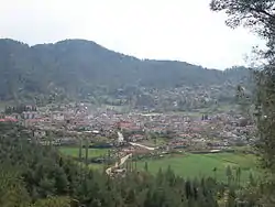
Yayladağı
Yayladağı (pronounced [ˈjajɫaˈdaɯ], Arabic: اوردو) is a town and district of Hatay Province in southern Turkey, on the border between Turkey and Syria, 51 km (32 mi) south of the city of Antakya.
Yayladağı | |
|---|---|
 | |
 Yayladağı | |
| Coordinates: 35°54′09″N 36°03′38″E | |
| Country | Turkey |
| Province | Hatay |
| Government | |
| • Mayor | Mustafa Kemal Dağıstanlı (MHP) |
| • Kaymakam | Tolga Polat |
| Area | |
| • District | 340.81 km2 (131.59 sq mi) |
| Elevation | 450 m (1,480 ft) |
| Population (2012)[2] | |
| • Urban | 6,814 |
| • District | 21,766 |
| • District density | 64/km2 (170/sq mi) |
| Post code | 31550 |
| Website | www.yayladagi.bel.tr |
Demography
The population of Yayladağı is mostly composed from Sunni Turkmen population. After the Syrian civil war broke out, nearly 2,000 Syrian Turkmens were displaced from Turkmen Mount to here.[3]
History
The district has a long history dating back to the Hittites. Islam was brought here by the Abbassid Arabs, and from 1075 onwards the Seljuk Turks. During the Crusades, the mountains were part of the principality of Antioch, then they returned to Muslim control, and in 1518 were brought into the Ottoman Empire by Sultan Selim I during his campaign into Egypt.
Geography
Today, Yayladağı itself is a small town of 5,717 people as of 2000 census, providing the district with a health centre, high schools and other basics.
This is a mountainous district with a typical Mediterranean climate of hot, dry summers and warm, wet winters, but being inland and high up, Yayladağı is cooler than most of Hatay, even seeing snow on the mountain peaks in winter. The main source of income is agriculture, 96 km2 (37 sq mi) of the land (small valleys and plateau in the mountains) is cultivated with olives, tobacco, vegetables, grains and other crops, the remainder is forest and mountain. The mountainsides are covered with pine, sandalwood and rough oak, or else shrubs including bay, thyme and oleander. Animals, especially goats, are grazed on the hillsides.
Yayladağı has a border crossing into Syria, and the village of Topraktutan, Turkey's southernmost point. The state road ![]() D.825 (European route
D.825 (European route ![]() E91) connects the border checkpoint with Antakya.
E91) connects the border checkpoint with Antakya.
Places of interest
- Kasım Bey Cami - Yayladağı's oldest mosque, built by the Avar lord that captured the area from the Byzantines. Other historical buildings include the 500-year-old mosque Hacı Hüseyin Camii, and a Roman bridge. There are ancient churches including the Monastery of Saint Barlaam on the Kel Dağı mountain, others in the villages of Çabala and Olgunlar, and the monastery named Kızlar Sarayı. There are also a number of caves and places said to possess healing powers.
References
- "Area of regions (including lakes), km²". Regional Statistics Database. Turkish Statistical Institute. 2002. Retrieved 2013-03-05.
- "Population of province/district centers and towns/villages by districts - 2012". Address Based Population Registration System (ABPRS) Database. Turkish Statistical Institute. Retrieved 2013-02-27.
- Bayırbucak Türkmenleri Yayladağı'ndaki kampa alınıyor
External links
- District governorate's official website (in Turkish)
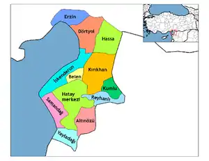
Yayladağı in Hatay Province of Turkey | |||||||||||||||||||||||||||
|---|---|---|---|---|---|---|---|---|---|---|---|---|---|---|---|---|---|---|---|---|---|---|---|---|---|---|---|
| Districts | Districts of Hatay | ||||||||||||||||||||||||||
| |||||||||||||||||||||||||||
Metropolitan municipalities are bolded. | |||||||||||||||||||||||||||
| Authority control |
|---|