79th parallel north
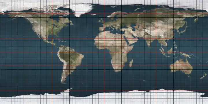
The 79th parallel north is a circle of latitude that is 79 degrees north of the Earth's equatorial plane, in the Arctic. It crosses the Atlantic Ocean, Europe, Asia, the Arctic Ocean and North America.
.svg.png.webp)
79°
79th parallel north
At this latitude the sun is visible for 24 hours, 0 minutes during the summer solstice and astronomical twilight during the winter solstice.
Around the world
Starting at the Prime Meridian and heading eastwards, the parallel 79° north passes through:
Co-ordinates Country, territory or sea Notes 79°0′N 0°0′E Atlantic Ocean Greenland Sea 79°0′N 12°5′E 
Svalbard - island of Spitsbergen 79°0′N 20°11′E Barents Sea Passing just north of the island of Kongsøya, Svalbard, 79°0′N 30°4′E Svalbard - island of Abeløya 79°0′N 30°19′E Barents Sea 79°0′N 67°0′E Kara Sea 79°0′N 95°44′E 
Severnaya Zemlya - October Revolution Island 79°0′N 99°58′E Laptev Sea 79°0′N 101°6′E Severnaya Zemlya - Bolshevik Island 79°0′N 104°5′E Laptev Sea 79°0′N 114°28′E Arctic Ocean 79°0′N 104°40′W .svg.png.webp)
Nunavut - Ellef Ringnes Island 79°0′N 101°21′W Peary Channel 79°0′N 94°12′W Nunavut - Axel Heiberg Island, Stor Island and Ellesmere Island 79°0′N 76°7′W Nares Strait 79°0′N 68°48′W 
79°0′N 19°52′W Atlantic Ocean Greenland Sea 79°0′N 68°43′W North of Inuarfissuaq (Cap Russel) 79°0′N 17°57′W Main island of Norske Islands 79°0′N 17°40′W Atlantic Ocean Greenland Sea
See also
 |
This article is issued from Wikipedia. The text is licensed under Creative Commons - Attribution - Sharealike. Additional terms may apply for the media files.
