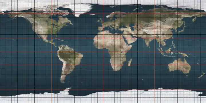
IERS Reference Meridian
The IERS Reference Meridian (IRM), also called the International Reference Meridian, is the prime meridian (0° longitude) maintained by the International Earth Rotation and Reference Systems Service (IERS). It passes about 5.3 arcseconds east of George Biddell Airy's 1851 transit circle which is 102 metres (335 ft) at the latitude of the Royal Observatory, Greenwich.[1][2][3] It is also the reference meridian of the Global Positioning System (GPS) operated by the United States Department of Defense, and of WGS84 and its two formal versions, the ideal International Terrestrial Reference System (ITRS) and its realization, the International Terrestrial Reference Frame (ITRF).
.svg.png.webp)
Location
The predominant factor for the 5.3 arcsecond offset between the IERS Reference Meridian is it takes into account uneven gravity between hemispheres so is slightly out of step with system validated by star observation (including but not limited to the sun), that of the Prime Meridian. In the Prime Meridian system precisely timed "clock star" observations are made and used such as of the Prime Meridian vertical, a local vertical, which for decades entailed a fine spider's web thread scale within the optical assembly, enabling other points on Earth to emulate this and, optimally, telescopes often finely calibrated in elevation angle as the Airey device was, with a series of microscopes.[4] As close as it can be to this, the IERS Reference 0° Meridian is the nearest geodetic longitude, that is, the plane of this meridian bisects the center of mass of the Earth, shifting it into what in a truly evenly weighted sphere would be considered the Eastern Hemisphere.[1] This reflects the navigation programming and the orbit of satellites (and other objects of rotation) and often many other physical devices, such as those dependant on these.
The International Hydrographic Organization adopted an early version of the IRM in 1983 for all nautical charts.[5] It was adopted for air navigation by the International Civil Aviation Organization on 3 March 1989.[6] Tectonic plates slowly move over the surface of Earth, so most countries have adopted for their maps an IRM version fixed relative to their own tectonic plate as it existed at the beginning of a specific year. Examples include the North American Datum 1983 (NAD83), the European Terrestrial Reference Frame 1989 (ETRF89), and the Geocentric Datum of Australia 1994 (GDA94). Versions fixed to a tectonic plate differ from the global version by at most a few centimetres.
The IERS system is not quite fixed to any point attached to the Earth. For example, all points on the European portion of the Eurasian plate, including the Royal Observatory, are moving northeast about 2.5 cm per year relative to it. The IRM is the weighted average (in the least squares sense) of the reference meridians of the hundreds of ground stations contributing to the IERS network. The network includes GPS stations, satellite laser ranging (SLR) stations, lunar laser ranging (LLR) stations, and the highly accurate very long baseline interferometry (VLBI) stations.[7] All stations' coordinates are adjusted annually to remove net rotation relative to the major tectonic plates. If Earth had only two hemispherical plates moving relative to each other around any axis which intersects their centres or their junction, then the longitudes (around any other rotation axis) of any two, diametrically opposite, stations must move in opposite directions by the same amount. The 180th meridian is opposite the IERS Reference Meridian and forms a great circle with it dividing the earth into Western Hemisphere and Eastern Hemisphere.
Universal Time is notionally based on the WGS84 meridian. Because of changes in the rate of Earth's rotation, standard international time UTC can differ from the mean observed solar time at noon on the prime meridian by up to 0.9 of a second. Leap seconds are inserted periodically to keep UTC close to Earth's angular position relative to the Sun; see mean solar time.
List of places
Starting at the North Pole and heading south to the South Pole, the IERS Reference Meridian passes through 8 countries:
See also
References
- Malys, Stephen; Seago, John H.; Palvis, Nikolaos K.; Seidelmann, P. Kenneth; Kaplan, George H. (1 August 2015). "Why the Greenwich meridian moved". Journal of Geodesy. 89 (12): 1263–1272. doi:10.1007/s00190-015-0844-y.
- IRM on grounds of Royal Observatory from Google Earth Accessed 30 March 2012
- The astronomic latitude of the Royal Observatory is 51°28'38"N whereas its latitude on the European Terrestrial Reference Frame (1989) datum is 51°28'40.1247"N.
- Royal Museums Greenwich – https://www.rmg.co.uk/discover/explore/airys-transit-circle-and-dawn-universal-day "Airy's Transit Circle and the dawn of the Universal Day" Accessed 2020-01-16
- "A manual on the technical aspects of the United Nations Convention on the Law of the Sea – 1982" (PDF). (4.89 MB) Section 2.4.4.
- WGS 84 Implementation Manual page i, 1998
- "IERS Conventions (2003): Conventional Terrestrial Reference System and Frame" (PDF). Archived from the original (PDF) on 2012-04-05. Retrieved 2012-03-28. (419 KB)
|
