Andrew County, Missouri
Andrew County is a county located in the northwestern part of the U.S. state of Missouri. As of the 2010 census, the county had a population of 17,291.[1] Its county seat is Savannah.[2] The county was organized January 29, 1841, and named for Andrew Jackson Davis, a lawyer and prominent citizen of St. Louis.[3]
Andrew County | |
|---|---|
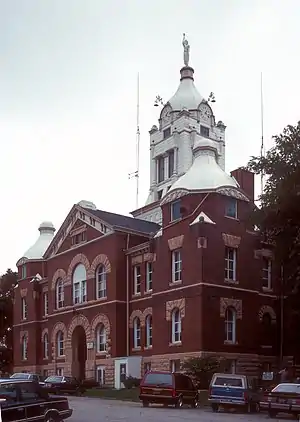 Andrew County Courthouse | |
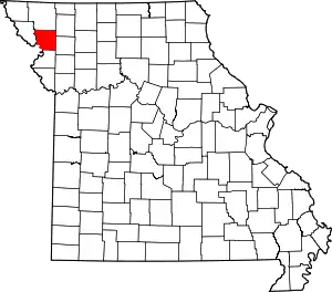 Location within the U.S. state of Missouri | |
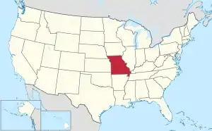 Missouri's location within the U.S. | |
| Coordinates: 39°59′N 94°48′W | |
| Country | |
| State | |
| Founded | January 29, 1841 |
| Named for | Andrew Jackson Davis |
| Seat | Savannah |
| Largest city | Savannah |
| Area | |
| • Total | 436 sq mi (1,130 km2) |
| • Land | 433 sq mi (1,120 km2) |
| • Water | 3.7 sq mi (10 km2) 0.9% |
| Population (2010) | |
| • Total | 17,291 |
| • Estimate (2018) | 17,607 |
| • Density | 40/sq mi (15/km2) |
| Time zone | UTC−6 (Central) |
| • Summer (DST) | UTC−5 (CDT) |
| Congressional district | 6th |
| Website | www |
Andrew County is part of the St. Joseph, MO–KS Metropolitan Statistical Area, which is included in the Kansas City-Overland Park-Kansas City Combined statistical area.
History
The following material is inscribed on a plaque erected by the State Historical Society of Missouri and State Highway Commission in 1960, now located by the Andrew County Courthouse:
Andrew County, organized 1841, is one of six counties in the Indian Platte Purchase Territory annexed to Missouri in 1837. Named for Andrew Jackson Davis, a St. Louis editor, the county was first settled in the middle 1830s. Pioneers were from Ohio, Indiana, Tennessee, Kentucky, Virginia, and other parts of Missouri.
Savannah, the county seat, was laid out in 1841. First briefly called Union, it was renamed for Savannah, Georgia. The Platte County Railroad (CB&Q) reached there in 1860, and today's Chicago, Great Western in the late 1880s. The town grew as a shipping point and trading center in the post Civil War era.
Divided during the Civil War, Andrew County sent troops to both sides. In August 1861, 1,500 soldiers from Andrew County and other counties joined the pro-Southern Missouri State Guard at Camp Highly in eastern Andrew County while others joined a large Union cap in adjacent Gentry County. In 1861, Union troops seized "Northwest Democrat," a pro-Southern newspaper, in Savannah and troops from Camp Highly seized the "Plain Dealer," a Union newspaper. Raiding guerrilla bands overran the county through 1863.
Andrew County's glacial plains support fertile livestock, grain, and fruit farms. The One Hundred and Two River, along with the Platte River, are located in the county. Its western border is formed by the Nodaway and Missouri rivers. In 1804 the Lewis and Clark Expedition camped on an island at the mouth of the Nodaway River. Members of fur trader W. Price Hunt's 1811 Astorian expedition wintered near the river's mouth as well.
Among the towns located in Andrew County are Amazonia, once on the Missouri River, now inland, laid out in 1857 near the site of Nodaway City, an early river port; Fillmore, established in 1845; Whitesville, established in 1848; Rochester, established in 1848; Bolckow, established in 1868; Rosendale, established in 1869; Rea, established in 1877; Helena, established in 1878; and Cosby, established in 1882.
The Andrew County Museum & Historical Society celebrates the history of Andrew County through exhibits, programs, publications, and special events. The museum and society collects, preserves, researches, and interprets documents and artifacts to promote the appreciation and preservation of the county's history and bring history to life in Andrew County.[4]
Geography
According to the U.S. Census Bureau, the county has a total area of 436 square miles (1,130 km2), of which 433 square miles (1,120 km2) is land and 3.7 square miles (9.6 km2) (0.9%) is water.[5]
Adjacent counties
- Nodaway County (north)
- Gentry County (northeast)
- DeKalb County (east)
- Buchanan County (south)
- Doniphan County, Kansas (southwest)
- Holt County (west)
Major highways
.svg.png.webp) Interstate 29
Interstate 29.svg.png.webp) Interstate 229
Interstate 229 U.S. Route 59
 U.S. Route 71
 U.S. Route 169
 Route 48
Demographics
| Historical population | |||
|---|---|---|---|
| Census | Pop. | %± | |
| 1850 | 9,433 | — | |
| 1860 | 11,850 | 25.6% | |
| 1870 | 15,137 | 27.7% | |
| 1880 | 16,318 | 7.8% | |
| 1890 | 16,000 | −1.9% | |
| 1900 | 17,332 | 8.3% | |
| 1910 | 15,282 | −11.8% | |
| 1920 | 14,075 | −7.9% | |
| 1930 | 13,469 | −4.3% | |
| 1940 | 13,015 | −3.4% | |
| 1950 | 11,727 | −9.9% | |
| 1960 | 11,062 | −5.7% | |
| 1970 | 11,913 | 7.7% | |
| 1980 | 13,908 | 16.7% | |
| 1990 | 14,632 | 5.2% | |
| 2000 | 16,492 | 12.7% | |
| 2010 | 17,291 | 4.8% | |
| 2018 (est.) | 17,607 | [6] | 1.8% |
| U.S. Decennial Census[7] 1790-1960[8] 1900-1990[9] 1990-2000[10] 2010-2015[1] | |||
As of the census[11] of 2000, there were 16,492 people, 6,273 households, and 4,635 families residing in the county. The population density was 38 people per square mile (15/km2). There were 6,662 housing units at an average density of 15 per square mile (6/km2). The racial makeup of the county was 98.38% White, 0.42% Black or African American, 0.34% Native American, 0.22% Asian, 0.01% Pacific Islander, 0.18% from other races, and 0.45% from two or more races. Approximately 0.84% of the population were Hispanic or Latino of any race.
There were 6,273 households, out of which 34.50% had children under the age of 18 living with them, 62.70% were married couples living together, 7.40% had a female householder with no husband present, and 26.10% were non-families. 22.30% of all households were made up of individuals, and 10.50% had someone living alone who was 65 years of age or older. The average household size was 2.59 and the average family size was 3.03.
In the county, the population was spread out, with 26.40% under the age of 18, 7.90% from 18 to 24, 27.60% from 25 to 44, 23.70% from 45 to 64, and 14.40% who were 65 years of age or older. The median age was 38 years. For every 100 females, there were 95.00 males. For every 100 females age 18 and over, there were 93.00 males.
The median income for a household in the county was $40,688, and the median income for a family was $46,067. Males had a median income of $32,955 versus $22,586 for females. The per capita income for the county was $19,375. About 6.40% of families and 8.20% of the population were below the poverty line, including 10.50% of those under age 18 and 8.00% of those age 65 or over.
Education
Public schools
- Avenue City R-IX School District – Cosby
- Avenue City Elementary School (PK-08)
- North Andrew County R-VI School District – Rosendale
- North Andrew County Elementary School (K-05)
- North Andrew County Middle School (06-08)
- North Andrew County High School (09-12)
- Savannah R-III School District – Savannah
- Amazonia Elementary School (K-05)
- Helena Elementary School (K-05)
- John Glenn Elementary School (K-05)
- Minnie Cline Elementary School (PK-05)
- Savannah Middle School (06-08)
- Savannah High School (09-12)
Public libraries
- Rolling Hills Consolidated Library—Savannah Branch[12]
Politics
Local
| Andrew County, Missouri | |||
|---|---|---|---|
| Elected countywide officials | |||
| Assessor | Paul Garrison | Republican | |
| Circuit Clerk | Christy Porter | Republican | |
| County Clerk | Sarah Miller | Republican | |
| Collector | Phil Rogers | Republican | |
| Commissioner (Presiding) | Bob Caldwell | Republican | |
| Commissioner (District 1) | Fritz Hegeman | Republican | |
| Commissioner (District 2) | Gary Baumann | Republican | |
| Coroner | Doug Johnson | Republican | |
| Prosecuting Attorney | Steven Stevenson | Republican | |
| Public Administrator | Janet Rosenauer | Republican | |
| Recorder | Chanler Williams | Republican | |
| Sheriff | Bryan Atkins | Republican | |
| Surveyor | F. Shane Terhune | Republican | |
| Treasurer | Cindy Esely | Republican | |
State
| Year | Republican | Democratic | Third Parties |
|---|---|---|---|
| 2016 | 63.22% 5,771 | 34.79% 3,176 | 1.98% 181 |
| 2012 | 51.99% 4,301 | 44.63% 3,692 | 3.38% 280 |
| 2008 | 48.09% 4,174 | 49.69% 4,313 | 2.22% 192 |
| 2004 | 60.70% 5,001 | 38.15% 3,143 | 1.15% 95 |
| 2000 | 54.55% 3,943 | 43.47% 3,142 | 1.98% 143 |
| 1996 | 37.24% 2,607 | 60.33% 4,223 | 2.43% 170 |
| 1992 | 50.00% 3,657 | 50.00% 3,657 | 0.00% 0 |
All of Andrew County is a part of Missouri's 9th District in the Missouri House of Representatives and is represented by Delus Johnson (R-St. Joseph).
| Party | Candidate | Votes | % | ±% | |
|---|---|---|---|---|---|
| Republican | Delus Johnson | 8,001 | 100.00% | ||
| Party | Candidate | Votes | % | ±% | |
|---|---|---|---|---|---|
| Republican | Delus Johnson | 4,188 | 100.00% | ||
| Party | Candidate | Votes | % | ±% | |
|---|---|---|---|---|---|
| Republican | Delus Johnson | 7,079 | 100.00% | ||
All of Andrew County is a part of Missouri's 12th District in the Missouri Senate and is currently represented by Dan Hegemen (R-Cosby).
| Party | Candidate | Votes | % | ±% | |
|---|---|---|---|---|---|
| Republican | Dan Hegeman | 4,228 | 100.00% | ||
Federal
| Party | Candidate | Votes | % | ±% | |
|---|---|---|---|---|---|
| Republican | Roy Blunt | 5,610 | 61.63% | +17.08 | |
| Democratic | Jason Kander | 3,122 | 34.30% | -13.75 | |
| Libertarian | Jonathan Dine | 213 | 2.34% | -5.05 | |
| Green | Johnathan McFarland | 83 | 0.91% | +0.91 | |
| Constitution | Fred Ryman | 74 | 0.81% | +0.81 | |
| Party | Candidate | Votes | % | ±% | |
|---|---|---|---|---|---|
| Republican | Todd Akin | 3,664 | 44.55% | ||
| Democratic | Claire McCaskill | 3,952 | 48.05% | ||
| Libertarian | Jonathan Dine | 608 | 7.39% | ||
All of Andrew County is included in Missouri's 6th Congressional District and is currently represented by Sam Graves (R-Tarkio) in the U.S. House of Representatives.
| Party | Candidate | Votes | % | ±% | |
|---|---|---|---|---|---|
| Republican | Sam Graves | 6,748 | 74.71% | +7.01 | |
| Democratic | David M. Blackwell | 2,021 | 22.38% | -6.53 | |
| Libertarian | Russ Lee Monchil | 179 | 1.98% | -1.42 | |
| Green | Mike Diel | 84 | 0.93% | +0.93 | |
| Party | Candidate | Votes | % | ±% | |
|---|---|---|---|---|---|
| Republican | Sam Graves | 3,328 | 67.70% | -2.74% | |
| Democratic | Bill Hedge | 1,421 | 28.91% | +1.80 | |
| Libertarian | Russ Lee Monchil | 167 | 3.40% | +0.95 | |
| Party | Candidate | Votes | % | ±% | |
|---|---|---|---|---|---|
| Republican | Sam Graves | 5,769 | 70.44% | ||
| Democratic | Kyle Yarber | 2,220 | 27.11% | ||
| Libertarian | Russ Lee Monchil | 201 | 2.45% | ||
| Year | Republican | Democratic | Third parties |
|---|---|---|---|
| 2020 | 73.3% 7,255 | 23.8% 2,351 | 1.5% 146 |
| 2016 | 72.5% 6,665 | 22.2% 2,045 | 5.3% 484 |
| 2012 | 65.4% 5,457 | 31.8% 2,649 | 2.8% 235 |
| 2008 | 60.1% 5,279 | 38.1% 3,345 | 1.9% 166 |
| 2004 | 62.1% 5,135 | 37.1% 3,069 | 0.8% 62 |
| 2000 | 58.5% 4,257 | 38.4% 2,795 | 3.1% 222 |
| 1996 | 46.2% 3,281 | 39.5% 2,807 | 14.3% 1,013 |
| 1992 | 35.4% 2,652 | 35.7% 2,675 | 28.9% 2,162 |
| 1988 | 52.1% 3,407 | 47.5% 3,108 | 0.4% 27 |
| 1984 | 63.4% 4,252 | 36.6% 2,457 | |
| 1980 | 56.1% 3,690 | 39.2% 2,575 | 4.7% 308 |
| 1976 | 50.4% 3,130 | 49.0% 3,042 | 0.7% 41 |
| 1972 | 71.3% 4,180 | 28.7% 1,686 | |
| 1968 | 59.0% 3,398 | 34.8% 2,005 | 6.2% 359 |
| 1964 | 44.7% 2,594 | 55.3% 3,211 | |
| 1960 | 63.1% 3,716 | 36.9% 2,170 | |
| 1956 | 60.1% 3,609 | 39.9% 2,393 | |
| 1952 | 67.9% 4,452 | 32.1% 2,104 | 0.1% 6 |
| 1948 | 54.8% 3,142 | 45.0% 2,576 | 0.2% 11 |
| 1944 | 62.3% 3,734 | 37.6% 2,254 | 0.1% 7 |
| 1940 | 58.8% 4,384 | 41.0% 3,059 | 0.2% 11 |
| 1936 | 51.8% 3,987 | 48.1% 3,702 | 0.1% 4 |
| 1932 | 46.0% 2,826 | 53.4% 3,280 | 0.5% 32 |
| 1928 | 66.6% 4,243 | 33.2% 2,118 | 0.2% 12 |
| 1924 | 55.4% 3,535 | 41.5% 2,648 | 3.2% 202 |
| 1920 | 60.9% 3,913 | 38.4% 2,466 | 0.8% 50 |
| 1916 | 52.5% 2,087 | 46.6% 1,853 | 0.9% 36 |
| 1912 | 42.0% 1,634 | 45.0% 1,750 | 13.0% 505 |
| 1908 | 54.1% 2,169 | 44.4% 1,782 | 1.5% 59 |
| 1904 | 56.5% 2,306 | 41.4% 1,691 | 2.2% 88 |
| 1900 | 53.1% 2,356 | 45.5% 2,022 | 1.4% 63 |
| 1896 | 50.3% 2,252 | 48.9% 2,191 | 0.9% 38 |
| 1892 | 48.5% 1,834 | 39.8% 1,505 | 11.6% 439 |
| 1888 | 52.9% 1,976 | 45.3% 1,691 | 1.9% 70 |
Missouri Presidential Preference Primary (2008)
- Former U.S. Senator Hillary Clinton (D-New York) received more votes, a total of 1,067, than any candidate from either party in Andrew County during the 2008 presidential primary.
| Andrew County, Missouri | |
|---|---|
| 2008 Republican primary in Missouri | |
| John McCain | 501 (27.96%) |
| Mike Huckabee | 484 (27.01%) |
| Mitt Romney | 641 (35.77%) |
| Ron Paul | 120 (6.70%) |
| Andrew County, Missouri | |
|---|---|
| 2008 Democratic primary in Missouri | |
| Hillary Clinton | 1,067 (56.94%) |
| Barack Obama | 746 (39.81%) |
| John Edwards (withdrawn) | 39 (2.08%) |
| Uncommitted | 16 (0.85%) |
Communities
Villages
Unincorporated communities
Notable people
- Nellie Tayloe Ross, the first female Governor of Wyoming (1925-1927) and first elected female Governor of any state in the United States, as well as the first female director of the U.S. Mint
- Joseph K. Toole (1851-1929), the first Governor of Montana and member of the Democratic Party
- John P. Altgeld, Governor of Illinois from 1893 to 1897, lived in Savannah
- Eminem, American rapper, lived in Savannah and attended middle school there
See also
- National Register of Historic Places listings in Andrew County, Missouri
References
- "State & County QuickFacts". United States Census Bureau. Archived from the original on July 6, 2011. Retrieved September 7, 2013.
- "Find a County". National Association of Counties. Archived from the original on 2011-05-31. Retrieved 2011-06-07.
- Eaton, David Wolfe (1916). How Missouri Counties, Towns and Streams Were Named. The State Historical Society of Missouri. pp. 202.
- "2010 Census Gazetteer Files". United States Census Bureau. August 22, 2012. Archived from the original on October 21, 2013. Retrieved November 13, 2014.
- "Population and Housing Unit Estimates". Retrieved November 29, 2019.
- "U.S. Decennial Census". United States Census Bureau. Retrieved November 13, 2014.
- "Historical Census Browser". University of Virginia Library. Retrieved November 13, 2014.
- "Population of Counties by Decennial Census: 1900 to 1990". United States Census Bureau. Retrieved November 13, 2014.
- "Census 2000 PHC-T-4. Ranking Tables for Counties: 1990 and 2000" (PDF). United States Census Bureau. Retrieved November 13, 2014.
- "U.S. Census website". United States Census Bureau. Retrieved 2011-05-14.
- Breeding, Marshall. "Rolling Hills Consolidated Library -- Savannah Branch". Libraries.org. Retrieved May 8, 2017.
- Leip, David. "Dave Leip's Atlas of U.S. Presidential Elections". uselectionatlas.org. Retrieved 2018-03-24.
External links
- Digitized 1930 Plat Book of Andrew County from University of Missouri Division of Special Collections, Archives, and Rare Books
Places adjacent to Andrew County, Missouri | ||||||||||
|---|---|---|---|---|---|---|---|---|---|---|
| ||||||||||
Municipalities and communities of Andrew County, Missouri, United States | ||
|---|---|---|
| Cities | Map of Missouri highlighting Andrew County | |
| Villages | ||
| Townships | ||
| Unincorporated communities | ||
| Ghost towns | ||
| ||
| Authority control |
|---|