Ardahan
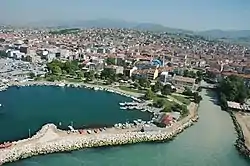
Ardahan (Kurdish: Erdêxan,[3] Armenian: Արդահան,[4] Georgian: არტაანი, romanized: art'aani[5]) is a city in northeastern Turkey, near the Georgian border. It is the capital of Ardahan Province.
Ardahan | |
|---|---|
 | |
 Ardahan  Ardahan  Ardahan | |
| Coordinates: 41°06′40″N 42°42′08″E | |
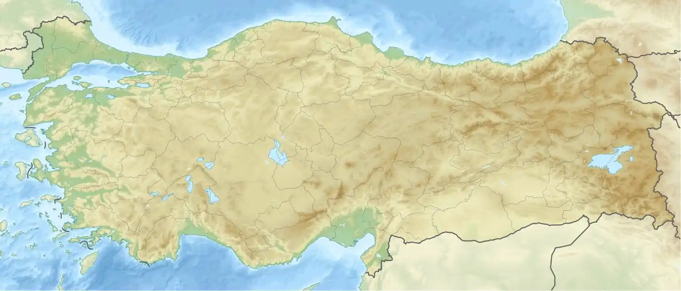
| Country | Turkey |
| Province | Ardahan |
| Government | |
| • Mayor | Faruk Demir (CHP) |
| Area | |
| • District | 1,191.37 km2 (459.99 sq mi) |
| Elevation | 1,811 m (5,942 ft) |
| Population (2012)[2] | |
| • Urban | 19,075 |
| • District | 41,770 |
| • District density | 35/km2 (91/sq mi) |
| Website | www.ardahan.bel.tr |
History
Ancient and medieval
The first surviving record about this region is attributed to Strabo, who calls it Gogarene (Gugark) and mentions that it was a part of the Armenia, taken away from the Kingdom of Iberia.[6][7] In the Middle Ages Ardahan served as an important transit point for goods arriving from the Abbasid Caliphate and departing to the regions around the Black Sea. During the 8th to 10th centuries the region was in hands of the Bagrationi princes of Tao-Klarjeti, and later part of Kingdom of Georgia between 11th to 15th centuries. According to the Arab historian Yahya of Antioch, the Byzantines razed Ardahan and slaughtered its population in 1021.[7] The Mongols took hold of the city in the 1230s but the Georgian princes of Samtskhe were able to recapture it in 1266. In 1555, by the Peace of Amasya, the western part of the principality of Samtskhe was annexed by the Ottoman Empire,[8] and Ardahan was included into the sanjak of Ardahan (an overall part of the vilayet of Akhaltsikhe).[9] The Ottomans constructed a substantial fortress at Ardahan. The Turkish traveler Evliya Çelebi visited Ardahan in the 1640s and gave the following description: "The fortress of Ardahan sits atop an inaccessible cliff. It is square-shaped and sturdy... This fortress has a cold climate and, because of this, there are no gardens or orchards. Fruits arrive from the fortress at Ajara and Tortum."[10]
Modern
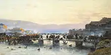
Aleksey Kivshenko.
Before 1829 Ardahan was recorded to have had 400 households, the great majority of them Armenian.[7] Many of them later immigrated to the Russian Empire. During the Russo-Turkish War (1828–1829) it was an important road junction connecting the border fortress of Akhaltsikhe to the Kars-Erzerum road. The town passed into the hands of Russia following the 1877-1878 Russo-Turkish War and was made a part of the Kars Oblast. The majority of the town was made up of Armenians, while other ethnic groups included Georgians, Pontic Greeks (here usually called Caucasus Greeks), Caucasus Jews, Russians, Kurds, Ossetians, and Yazidis.[7][9] The town flourished economically under Russian rule, exporting fruits, smoked lamb meat, wheat and wood. New roads were constructed, linking Ardahan to Akhalkalak, Kars and Oltu. On December 25, 1914, in the early months of the First World War, the Ottoman army occupied Ardahan and massacred many of its Armenians, Pontic Greeks, and Georgians.[9] The Russians, with the help of Armenian and Pontic Greek militias, captured the town on January 3, 1915, allowing some of the original inhabitants who had fled to return.
As Russian forces withdrew from the front following the October Revolution, a small Armenian volunteer force took up positions to defend the town from the approaching Ottoman Army. On March 6, 1918, the Ottoman army, along with the help of the town's Muslims, overwhelmed Ardahan's Armenian garrison and retook the town. The British occupied Ardahan after the end of the First World War and eventually handed control over it to the Democratic Republic of Armenia. When the Turkish Nationalists captured Ardahan in November 1920, the town's remaining Armenians, Pontic Greeks, and Georgians fled to Armenia, northern Greece, and Georgia.[9] The Treaty of Moscow, signed the following year between the Soviets and the Turks, confirmed Ardahan as a part of Turkish territory.
In 1986 a brief description of the fortress was published.[11] The original late antique/medieval walls of Ardahan Kalesi were extensively rebuilt several times and in the 19th they were adapted to accommodate small cannons.
In 1960, Ardahan's population stood at 7,228 and was populated by both Kurds and Turks.[7]
Demographics
| Year | Total | Ethnic groups |
|---|---|---|
| 1886[12] | 778 | Turks 403 (51.8%), Russians 172 (22.1%), Armenians 141 (18.1%), |
| 1897[13] | 4,142 | Russians 1,331 (32.1%), Armenians 1,315 (31.7%), Turks 746 (18%) |
| 1960[14] | 7,228 | |
| 1970[14] | 13,399 | |
| 1980[14] | 14,912 | |
| 1990[15] | 16,761 | |
| 2000[14] | 17,274 | |
| 2010[14] | 16,251 | |
Villages
- Açıkyazı
- Ağzıpek
- Akyaka
- Alagöz
- Altaş
- Ardıçdere
- Aşağıkurtoğlu
- Bağdaşen
- Balgöze
- Balıkçılar
- Bayramoğlu
- Beşiktaş
- Binbaşar
- Büyüksütlüce
- Çağlayık
- Çalabaş
- Çamlıçatak
- Çataldere
- Çatalköprü
- Çeğilli
- Çetinsu
- Çimenkaya
- Çobanlı
- Dağcı
- Dağevi
- Dedegül
- Değirmenli
- Derindere
- Edegül
- Gölgeli
- Gürçayır
- Güzçimeni
- Güzelyurt
- Hacıali
- Hasköy
- Höçvan
- Kartalpınar
- Kazlıköy
- Kıraç
- Kocaköy
- Köprücük
- Küçüksütlüce
- Lehimli
- Meşedibi
- Nebioğlu
- Ölçek
- Ömerağa
- Ortageçit
- Otbiçen
- Ovapınar
- Samanbeyli
- Sazlıçayır
- Sarıyamaç
- Sugöze
- Sulakyurt
- Taşlıdere
- Tazeköy
- Tepeler
- Tepesuyu
- Tunçoluk
- Uzunova
- Yanlızçam
- Yaylacık
- Yokuşdibi
- Yukarıkurtoğlu
Climate
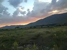
Ardahan has a warm summer humid continental climate (Dfb) under the Köppen classification, bordering on an alpine subarctic (Dfc) climate under the Köppen classification, and a cool summer continental climate (Dcb) under the Trewartha classification, with warm and brief summers with cool nights and very cold winters. Like in other parts of Eastern Anatolia, the climate turns subalpine on the hillsides. Major cities and towns have been situated on lower elevations for milder climatic conditions, as much as possible, therefore the city and the main towns have less characteristics of subalpine climate in comparison to the province in general.
Winters are very snowy with snow cover lasting from late October to mid April. Although sometimes it snows in September and May, it usually does not remain on the ground for long. On rare occasions it can even snow in summer months, especially early and late summer, such as the August 2013 incident. However strong snowfall was recorded even in July in the past. Average annual temperature is 3.8 °C (38.8 °F). The highest recorded temperature was 35 °C (95.0 °F) on 29 August 1998. The lowest recorded temperature was −39.8 °C (−39.6 °F) on 21 January 1972. The highest recorded snow thickness was 113 cm (44.5 inches) on 30 January 1968.
| Climate data for Ardahan (1961 to 2015) | |||||||||||||
|---|---|---|---|---|---|---|---|---|---|---|---|---|---|
| Month | Jan | Feb | Mar | Apr | May | Jun | Jul | Aug | Sep | Oct | Nov | Dec | Year |
| Record high °C (°F) | 11.0 (51.8) |
11.0 (51.8) |
18.4 (65.1) |
25.0 (77.0) |
26.4 (79.5) |
29.0 (84.2) |
34.3 (93.7) |
35.0 (95.0) |
30.6 (87.1) |
26.0 (78.8) |
18.2 (64.8) |
14.3 (57.7) |
35.0 (95.0) |
| Average high °C (°F) | −5.1 (22.8) |
−3.4 (25.9) |
2.5 (36.5) |
10.7 (51.3) |
16.1 (61.0) |
20.1 (68.2) |
23.8 (74.8) |
24.4 (75.9) |
20.7 (69.3) |
14.3 (57.7) |
6.4 (43.5) |
−2.0 (28.4) |
10.7 (51.3) |
| Daily mean °C (°F) | −11.3 (11.7) |
−10.0 (14.0) |
−3.5 (25.7) |
4.5 (40.1) |
9.5 (49.1) |
13 (55) |
16.3 (61.3) |
16.2 (61.2) |
12.3 (54.1) |
6.6 (43.9) |
−0.1 (31.8) |
−7.7 (18.1) |
3.8 (38.8) |
| Average low °C (°F) | −17.0 (1.4) |
−16.1 (3.0) |
−9.2 (15.4) |
−1.3 (29.7) |
3.1 (37.6) |
5.8 (42.4) |
8.7 (47.7) |
8.4 (47.1) |
4.3 (39.7) |
−0.2 (31.6) |
−5.5 (22.1) |
−12.8 (9.0) |
−2.6 (27.2) |
| Record low °C (°F) | −39.8 (−39.6) |
−38.7 (−37.7) |
−33.2 (−27.8) |
−22.2 (−8.0) |
−8.5 (16.7) |
−4.5 (23.9) |
−2.2 (28.0) |
−2.8 (27.0) |
−5.8 (21.6) |
−15.0 (5.0) |
−28.9 (−20.0) |
−36.3 (−33.3) |
−39.8 (−39.6) |
| Average precipitation mm (inches) | 19.0 (0.75) |
21.3 (0.84) |
31.3 (1.23) |
52.2 (2.06) |
82.6 (3.25) |
91.9 (3.62) |
71.8 (2.83) |
60.3 (2.37) |
35.3 (1.39) |
36.3 (1.43) |
27.1 (1.07) |
22.3 (0.88) |
551.4 (21.72) |
| Average precipitation days | 9.5 | 9.8 | 11.5 | 13.8 | 16.8 | 15.3 | 11.4 | 10.6 | 7.7 | 9.6 | 9.2 | 9.8 | 135 |
| Mean monthly sunshine hours | 74.4 | 96.1 | 173.6 | 153.0 | 204.6 | 255.0 | 263.5 | 257.3 | 219.0 | 167.4 | 138.0 | 74.4 | 2,076.3 |
| Percent possible sunshine | 25.3 | 32.2 | 46.9 | 38.2 | 45.4 | 56.0 | 57.2 | 60.1 | 58.6 | 48.7 | 46.8 | 26.1 | 45.1 |
| Source: Turkish State Meteorological Service[16] | |||||||||||||
See also
 Ardahan travel guide from Wikivoyage
Notes
- "Area of regions (including lakes), km²". Regional Statistics Database. Turkish Statistical Institute. 2002. Retrieved 5 March 2013.
- "Population of province/district centers and towns/villages by districts - 2012". Address Based Population Registration System (ABPRS) Database. Turkish Statistical Institute. Retrieved 27 February 2013.
- "Erdêxan". Ria Taza (in Kurdish). Retrieved 5 July 2020.
- Թորոսյան, Շիրակ. "Արդահանի հարցը հայ-վրացական հարաբերություններում և խնդրի ժամանակավոր լուծումը (1919 թ. մայիս-դեկտեմբեր)" (PDF). Yerevan State University: 1. Cite journal requires
|journal=(help) - "არტაანი" (in Georgian). National Parliamentary Library of Georgia. Retrieved 5 July 2020.
- Strabo. Geographica. 11.14.7.
- (in Armenian) «Արդահան» [Ardahan]. Armenian Soviet Encyclopedia. Yerevan: Armenian Academy of Sciences, 1976, vol. ii, p. 7.
- Mikaberidze, Alexander (2015). Historical Dictionary of Georgia (2 ed.). Rowman & Littlefield. p. xxxi. ISBN 978-1442241466.
- (in Armenian) Melkonyan, Ashot. «Արդահան» (Ardahan). Encyclopedia of the Armenian Question. Yerevan: Yerevan State University Press, 1996, p. 54.
- (in Armenian) Evliya Chelebi. Թուրքական Աղբյուրներ, Էվլիյա Չելեբի (Turkish Sources, Evliya Chelebi). Foreign Sources on Armenia and Armenians: Turkish Sources, Volume 3. Trans. and commentary by Aram Kh. Safrastyan. Yerevan: Oriental Department of Armenian Academy of Sciences, 1967, p. 113.
- Robert W. Edwards, "The Fortifications of Artvin: A Second Preliminary Report on the Marchlands of Northeast Turkey," Dumbarton Oaks Papers 40, 1986, pp.176-78, pls. 44-45.
- Свод статистических данных о населении Закавказского края, извлечённых из посемейных списков 1886 года, г. Тифлис, 1893. Available online here
- Первая всеобщая перепись населения Российской Империи 1897 г. Распределение населения по родному языку и уездам Российской Империи кроме губерний Европейской России (in Russian). Demoscope Weekly. Retrieved 8 April 2014.
- "Ardahan: Nüfus Bilgileri" (in Turkish). Belediyeler Konuşuyor. Archived from the original on 17 April 2014. Retrieved 17 April 2014.
- "Ardahan'ın Tarihçesi" (in Turkish). Ardahan Ticaret İl Müdürlüğü. Retrieved 17 April 2014.
Kentin 1990 yılı nüfusu 16,761'dir.
- "Meteoroloji" (in Turkish). Retrieved 8 January 2016.
External links
Further reading
| Wikimedia Commons has media related to Ardahan. |
| Wikivoyage has a travel guide for Ardahan. |
- (in Armenian) Kyureghyan, Levon. Կարս և Արտահան (Kars and Artahan). Vienna: Mkhitarian Press, 1949.
- (in Armenian) Yeremyan, Suren T. Հայաստանը ըստ «Աշխարհացույցի» (Armenia According to the Ashkharatsuyts). Yerevan: Armenian Academy of Sciences, 1963.
Ardahan in Ardahan Province of Turkey | |||||||||||||||||||||||||||
|---|---|---|---|---|---|---|---|---|---|---|---|---|---|---|---|---|---|---|---|---|---|---|---|---|---|---|---|
| Districts | 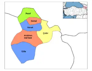 Districts of Ardahan | ||||||||||||||||||||||||||
| |||||||||||||||||||||||||||
Metropolitan municipalities are bolded. | |||||||||||||||||||||||||||
| Authority control |
|---|