Arthurson Ridge
Arthurson Ridge () is a short coastal ridge or promontory, a northern extension from the Wilson Hills, rising between Cook Ridge and the terminus of McLeod Glacier at the head of Davies Bay, Antarctica. It was photographed from aircraft of U.S. Navy Operation Highjump, 1946–47, and first visited by an Australian National Antarctic Research Expeditions (ANARE) airborne field party in March 1961. It was named for J. Arthurson, helicopter pilot with ANARE on the MV Magga Dan in 1961.
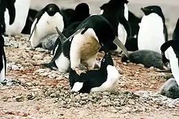
Mating Adélie penguins
Important Bird Area
The 154 ha ice-free outcrop has been identified as an Important Bird Area by BirdLife International because it supports a breeding colony of about 14,000 pairs of Adélie penguins. An emperor penguin colony is situated nearby in Davis Bay.[1]
References
- "Arthurson Ridge". BirdLife Data Zone. BirdLife International. 2015. Retrieved 23 October 2020.
 This article incorporates public domain material from the United States Geological Survey document: "Arthurson Ridge". (content from the Geographic Names Information System)
This article is issued from Wikipedia. The text is licensed under Creative Commons - Attribution - Sharealike. Additional terms may apply for the media files.