Dunlop Island
Dunlop Island is a rocky island, one nautical mile (2 km) long, lying just off the Wilson Piedmont Glacier and the coast of Victoria Land, close northeast of Cape Dunlop. It was first mapped by the British Antarctic Expedition, 1907–09, under Ernest Shackleton, who named it for H.J.L. Dunlop, chief engineer of the ship Nimrod.[1]
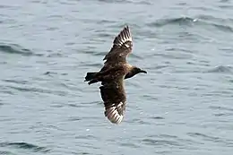
South polar skuas breed in the IBA
Important Bird Area
A 168 ha site comprising the whole island has been designated an Important Bird Area (IBA) by BirdLife International because it supports a breeding colony of south polar skuas, with some 88 breeding pairs reported in 1982.[2]
See also
- List of antarctic and sub-antarctic islands
References
- "Dunlop Island". Geographic Names Information System. United States Geological Survey. Retrieved 2012-02-20.
- "Dunlop Island". BirdLife Data Zone. BirdLife International. 2015. Retrieved 2 November 2020.
![]() This article incorporates public domain material from the United States Geological Survey document: "Dunlop Island". (content from the Geographic Names Information System)
This article incorporates public domain material from the United States Geological Survey document: "Dunlop Island". (content from the Geographic Names Information System)
This article is issued from Wikipedia. The text is licensed under Creative Commons - Attribution - Sharealike. Additional terms may apply for the media files.