Princess Ragnhild Coast
Princess Ragnhild Coast is the portion of the coast of Queen Maud Land in Antarctica lying between 20° E and the Riiser-Larsen Peninsula, at 34° E. All but the eastern end of the coast is fringed by ice shelves. It was discovered by Capt. Hjalmar Riiser-Larsen and Capt. Nils Larsen in aerial flights from the ship Norvegia on February 16, 1931, and named for Princess Ragnhild of Norway.[1] Vestvika Bay is a large bay on the west side of Riiser-Larsen Peninsula; it was mapped from air photos taken by the Lars Christensen Expedition, 1936–37, and named Vestvika, meaning "west bay."[2]
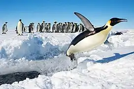
Important Bird Area
A 379 ha site on fast ice, within a crack in the ice shelf some 230 km west of the Riiser-Larsen Peninsula, has been designated an Important Bird Area (IBA) by BirdLife International because it supports a breeding colony of emperor penguins, initially discovered on 2009 satellite imagery and subsequently visited, with about 20,000 adults and chicks estimated in 2014.[3]
References
- "Princess Ragnhild Coast". Geographic Names Information System. United States Geological Survey. Retrieved 2019-05-02.
- "Vestvika Bay". Geographic Names Information System. United States Geological Survey. Retrieved 2019-05-02.
- "Princess Ragnhild Coast". BirdLife Data Zone. BirdLife International. 2015. Retrieved 21 November 2020.
![]() This article incorporates public domain material from websites or documents of the United States Geological Survey.
This article incorporates public domain material from websites or documents of the United States Geological Survey.