Empereur Island
Empereur Island is a rocky island 1.9 kilometres (1 nmi) north of Cape Margerie, lying immediately north of Breton Island in the entrance to Port Martin. It was photographed from the air by U.S. Navy Operation Highjump, 1946–47. It was charted by the French Antarctic Expedition under Andre-Frank Liotard, 1949–51, and so named because the first emperor penguin captured by the expedition was taken on this island.[1]
 Empereur Island Location in Antarctica | |
| Geography | |
|---|---|
| Location | Antarctica |
| Coordinates | 66°48′S 141°23′E |
| Administration | |
| Administered under the Antarctic Treaty System | |
| Demographics | |
| Population | Uninhabited |
Important Bird Area
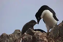
A 283 ha site, including Empereur Island and Île des Manchots, Mont du Sphinx and Mont du Sabbat on the eastern coast of Cape Margerie, as well as Pointe de Cézembre and the intervening sea, has been designated an Important Bird Area (IBA) by BirdLife International because it supports about 35,000 breeding pairs of Adélie penguinss, estimated from 20011 satellite imagery.[2]
References
- "Empereur Island". Geographic Names Information System. United States Geological Survey. Retrieved 2012-03-01.
- "Île des Manchots / Empereur Island". BirdLife Data Zone. BirdLife International. 2015. Retrieved 10 November 2020.
![]() This article incorporates public domain material from the United States Geological Survey document: "Empereur Island". (content from the Geographic Names Information System)
This article incorporates public domain material from the United States Geological Survey document: "Empereur Island". (content from the Geographic Names Information System)