Gregory Island (Antarctica)
Gregory Island is a small ice-free island lying just off the east coast of Victoria Land, Antarctica, 5 km (3.1 mi) north-east of Cape Archer and 8 km (5.0 mi) south of Cape Ross. It was discovered by the British National Antarctic Expedition (1901–04), at which time it was thought to be a coastal point and was named "Gregory Point," for John Walter Gregory, director of the civilian staff of the expedition. It was determined to be an island by the British Antarctic Expedition, 1910–13.[1]
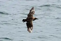 South polar skuas breed on the island | |
 Gregory Island Location in Antarctica | |
| Geography | |
|---|---|
| Location | Victoria Land, Antarctica |
| Coordinates | 76°48′51″S 162°57′44″E |
| Area | 70 ha (170 acres) |
| Length | 1.2 km (0.75 mi) |
| Width | 0.8 km (0.5 mi) |
| Highest elevation | 100 m (300 ft) |
| Administration | |
| Administered under the Antarctic Treaty System | |
| Demographics | |
| Population | Uninhabited |
Important Bird Area
A 51 ha site comprising the whole island has been designated an Important Bird Area (IBA) by BirdLife International because it supports a colony of south polar skuas, with an estimate of about 120 breeding pairs made in 1983. The nearest permanent research station the USA's McMurdo Station and New Zealand's Scott Base lying about 150 km to the south-east on Ross Island.[2]
References
- "Gregory Island". Geographic Names Information System. United States Geological Survey. Retrieved 2012-05-07.
- "Gregory Island". BirdLife Data Zone. BirdLife International. 2015. Retrieved 6 November 2020.
![]() This article incorporates public domain material from the United States Geological Survey document: "Gregory Island (Antarctica)". (content from the Geographic Names Information System)
This article incorporates public domain material from the United States Geological Survey document: "Gregory Island (Antarctica)". (content from the Geographic Names Information System)