Kloa Point
Kloa Point is a prominent coastal point projecting from the east side of Edward VIII Plateau, 5.6 kilometres (3 nmi) north of Cape Gotley, Antarctica. It was mapped by Norwegian cartographers from aerial photographs taken by the Lars Christensen Expedition, 1936–37, and called by them Kloa ('claw').[1]
Important Bird Area
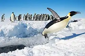
A 289 ha site on fast ice off the southern shore of the point has been designated an Important Bird Area (IBA) by BirdLife International because it supports about 3,300 breeding pairs of emperor penguins, based on 2009 satellite imagery. Weddell seals have been seen in the area.[2]
References
- "Kloa Point". Geographic Names Information System. United States Geological Survey. Retrieved 2013-05-10.
- "Kloa Point". BirdLife Data Zone. BirdLife International. 2015. Retrieved 12 November 2020.
![]() This article incorporates public domain material from the United States Geological Survey document: "Kloa Point". (content from the Geographic Names Information System)
This article incorporates public domain material from the United States Geological Survey document: "Kloa Point". (content from the Geographic Names Information System)